Itahari
| Itahari Upmahanagarpalika इटहरी उपमहानगरपालिका Itahari |
||
|---|---|---|
|
|
||
| Coordinates | 26 ° 40 ′ N , 87 ° 17 ′ E | |
| Basic data | ||
| Country | Nepal | |
| Province No. 1 | ||
| District | Sunsari | |
| ISO 3166-2 | NP-P1 | |
| height | 109 m | |
| surface | 93.7 km² | |
| Residents | 140,517 (2011) | |
| density | 1,499.2 Ew. / km² | |
| founding | 1996 | |
| Website | www.itaharimun.gov.np | |
| politics | ||
| Chief Executive Officer | Pahupati Khatiwada (September 2015) | |
| City law 2nd order 26 wards |
||
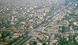
Itahari ( Nepali इटहरी , Iṭaharī ) is a city in Nepal in the Sunsari District , which belongs to Province No. 1 .
The city is located in the eastern Terai of Nepal at the crossroads of the main trade routes in eastern Nepal ( Mahendra Rajmarg and Koshi Rajmarg ) around 230 km southeast of the capital Kathmandu . The city's borders are not far from those of neighboring Dharan .
As part of the community reform in 2014, the Village Development Committees (VDCs) Ekamba , Hansaposa , Khanar and Pakali were incorporated. The urban area of Itahari grew to 93.73 km². Itahari has since then had the 2nd order town charter .
Residents
A 2011 census counted 74,501 inhabitants (in 18,270 households, 35,439 of whom were male). With the VDCs added in 2014, the population was 140,517 (66,566 male) in 33,794 households.
Web links
Individual evidence
- ↑ Municipal Association of Nepal (MuAN) ( Memento of the original from January 7, 2014 in the Internet Archive ) Info: The archive link was inserted automatically and has not yet been checked. Please check the original and archive link according to the instructions and then remove this notice.
- ↑ a b National Population and Housing Census 2011 (PDF; 2.1 MB) Central Bureau of Statistics. Archived from the original on July 31, 2013.

