Ivo (Bolivia)
| Ivo | ||
|---|---|---|
| Basic data | ||
| Residents (state) | 312 pop. (2012 census) | |
| height | 946 m | |
| Post Code | 01-1003-0300-4001 | |
| Telephone code | (+591) | |
| Coordinates | 20 ° 27 ′ S , 63 ° 26 ′ W | |
|
|
||
| politics | ||
| Department | Chuquisaca | |
| province | Luis Calvo Province | |
| climate | ||
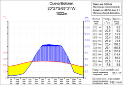
 Climate diagram Cuevo |
||
Ivo is a town in the Chuquisaca department in the lowlands of the South American Andean state of Bolivia .
Location in the vicinity
Ivo is the central place of the canton of Ivo in the district ( Bolivian : Municipio ) Macharetí in the province of Luis Calvo . The village is located at an altitude of 946 m on the right bank of the Río Cuevo , which seeps into the Municipio Boyuibe about 100 km further east . About six kilometers east of the village runs the Voranden chain of Serranía Aguaragüe , which runs from Boyuibe in the north via Villamontes to Yacuiba in the south and reaches heights of over 1,500 m at Ivo.
geography
Ivo is located in the humid subtropics between the mountainous region of the Cordillera de Tajsara o Tarachaca in the west and the Bolivian Chaco in the east.
The annual average temperature of the region is 23 ° C (see Cuevo climate diagram), the monthly values fluctuate between 18 ° C in June and July and 26 ° C in November and January. The climate is semi-humid and has a clear dry season from May to September with monthly rainfall of less than 20 mm; the annual precipitation is almost 800 mm, from December to March monthly values of 110 to 160 mm are reached.
Transport network
Ivo is located at a distance of 510 kilometers by road southeast of Sucre , the capital of the Chuquisaca department.
Sucre from the 976 km long leads highway Ruta 6 on Zudañez , Padilla , Monteagudo , Lagunillas and Camiri to Boyuibe . Fifteen kilometers before Boyuibe, the road crosses the Río Cuevo, and after another kilometer a dirt road branches off to the southwest from the Ruta 6, follows the Río Cuevo upstream and reaches Ivo after eight kilometers.
population
The population of the village has changed only insignificantly in the past two decades:
| year | Residents | source |
|---|---|---|
| 1992 | 299 | census |
| 2001 | 361 | census |
| 2010 | 312 | census |
Due to the historical distribution of the population, the region has a certain proportion of Guaraní population, in the municipality of Macharetí 19.2 percent of the population speak the Guaraní language .
Individual evidence
- ↑ INE - Instituto Nacional de Estadística Bolivia 1992 ( Memento of the original from April 23, 2014 in the Internet Archive ) Info: The archive link was inserted automatically and has not yet been checked. Please check the original and archive link according to the instructions and then remove this notice.
- ↑ INE - Instituto Nacional de Estadística Bolivia 2001 ( Memento of the original from October 29, 2013 in the Internet Archive ) Info: The archive link has been inserted automatically and has not yet been checked. Please check the original and archive link according to the instructions and then remove this notice.
- ↑ INE - Instituto Nacional de Estadística Bolivia 2012 ( Memento of the original from July 22, 2011 in the Internet Archive ) Info: The archive link has been inserted automatically and has not yet been checked. Please check the original and archive link according to the instructions and then remove this notice.
- ↑ INE social data Chuquisaca 2001 ( Memento of the original from October 29, 2013 in the Internet Archive ) Info: The archive link was inserted automatically and has not yet been checked. Please check the original and archive link according to the instructions and then remove this notice. (PDF; 4.4 MB)
Web links
- Municipio Macharetí - general maps no.11003
- Municipio Macharetí - detailed map and population data (PDF; 541 kB)
- Departamento Chuquisaca - Social data of the municipalities ( Spanish ) (PDF; 4.21 MB)
