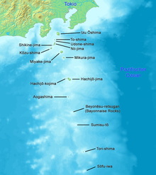
Izu Islands
The Izu Islands ( Japanese 伊豆 諸島 Izu-shotō ) are a chain of islands that extends southeast of the Izu Peninsula from the island of Honshū in a south direction into the Pacific . They are located around 100 to 350 km from the Japanese capital Tōkyō and are part of Tokyo Prefecture .
The islands are of volcanic origin and geologically belong to the Izu Bonin Mariana Islands arch . With the Ogasawara Islands , located 290 km further south-southeast and also belonging to this arch of islands , they are also grouped together as the "Southern Islands" ( Nampō-shotō ). They are the northeastern limit of the Philippine Sea .
The Izu Islands form part of the Fuji-Hakone-Izu National Park and are a recreation area of the greater Tōkyō region known for its natural beauty and water sports. When the weather is nice, many day-trippers go swimming, diving, fishing and surfing on the islands. The island chain is home to the best-known and largest breeding colonies of the Japanese alkus , a species of bird from the family of alken birds .
Islands
The island chain is made up of the following islands:
The two islands of Colunas , which were partially identified by Torishima and Sōfugan, are listed on historical European sea charts .
population
Izu-Ōshima, also Ōshima for short, is the northernmost and largest island, and has the highest population of all Izu islands. As the closest island to Tōkyō, it is visited by many tourists because of its centrally located, active volcano (Mihara, 758 m). With a slightly lower population, Hachijō-jima is the second largest island in the chain of islands, even after the area.
In the criminal law of the Tokugawa Shogunate , the islands, especially Hachijō-jima and Izu-Ōshima, served as a place of exile for offenders from eastern Japan , i.e. H. the province of Mino and east of it. The islands were used in this function for centuries. B. 675 a child of Prince Omis banished here, as well as Minamoto no Tametomo after the Hōgen rebellion in 1156.
The approximately 3,000 residents of Miyake-jima were evacuated in 2000 due to an impending oyama outbreak and most of them returned in summer 2005.
Administrative division of the island chain
Administrative affiliation of the islands to municipalities:
- Ōshima Sub-Prefecture
-
Miyake Sub-Prefecture
- Miyake : Miyake-jima and Ōnohara-jima
- Mikurajima : Mikura-jima and Inamba-jima
-
Hachijō Sub-Prefecture
-
 Hachijō : Hachijō-jima and Hachijō-kojima
 -
 Aogashima : Aogashima
 - Unparished area (de facto): Bayonnaise Rocks , Sumisu-tō , Torishima, and Sōfugan
-
For the Bayonnaise Rocks, Sumisu-tō, Torishima and Sōfugan, it is undecided whether they should be added to the municipality of Hachijō or Aogashima, which means that they are de facto municipality-free.
Web links
- Ōshima in Edutraveller (English)
- Tōkai Ferry Service Website (Japanese)
- Volcanoes of the Izu Islands MS Excel
- List of volcanoes ( Memento from July 19, 2012 in the web archive archive.today )
Individual evidence
- ↑ Anthony J. Gaston, Ian L. Jones: The Auks . Oxford University Press, Oxford 1998, ISBN 0-19-854032-9 , p. 223
- ↑ 遠 島 . In: 百科 事 典 マ イ ペ デ ィ ア at kotobank.jp. Hitachi Solutions, May 2010, accessed January 8, 2011 (Japanese).
- ↑ 麻 績 王 . In: 朝日 日本 歴 史 人物 事 典 at kotobank.jp. Retrieved January 24, 2018 (Japanese).
- ↑ 東京 都 . (PDF; 65.9 kB) (No longer available online.) In: 平 成 27 年 全国 都 道 府 県 市区 町 村 別 面積 調 . Kokudo Chiri-in , October 1, 2015, archived from the original on July 29, 2016 ; Retrieved August 3, 2016 (Japanese). Info: The archive link was inserted automatically and has not yet been checked. Please check the original and archive link according to the instructions and then remove this notice.


