Jaguariúna
| Município de Jaguariúna
"Jaguar"
Jaguariúna
"Estrela da Mogiana" |
|||
|---|---|---|---|
|
View over Jardim Cruzeiro do Sul in Jaguariúna
|
|||
|
|
|||
| Coordinates | 22 ° 42 ′ S , 46 ° 59 ′ W | ||
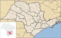
 Location of the municipality in the state of São Paulo Location of the municipality in the state of São Paulo
|
|||
| Symbols | |||
|
|||
|
Motto "Fide et labore" Faith and work |
|||
| founding | December 30, 1953 (town charter) (age 66) | ||
| Basic data | |||
| Country | Brazil | ||
| State | São Paulo | ||
| ISO 3166-2 | BR-SP | ||
| Metropolitan area | Campinas metropolitan area | ||
| height | 570 m | ||
| climate | tropical mountain climate, Cfa | ||
| surface | 141.4 km² | ||
| Residents | 44,311 (2010) | ||
| density | 313.4 Ew. / km² | ||
| estimate | 57,488 (July 1, 2019) | ||
| Parish code | IBGE : 3524709 | ||
| Post Code | 13910-000 to 13919-999 | ||
| Telephone code | (+55) 19 | ||
| Time zone | UTC −3 | ||
| Website | jaguariuna.sp (Brazilian Portuguese) | ||
| politics | |||
| City Prefect | Márcio Gustavo Bernardes Reis (2017–2020) | ||
| Political party | MDB | ||
| economy | |||
| GDP | 11,346,028 thousand R $ 209,321 R $ per person (2017) |
||
| HDI | 0.829 (very high) (2010) | ||
Jaguariúna , officially Portuguese Município de Jaguariúna , is a municipality in the Brazilian state of São Paulo . It is part of the metropolitan area of Campinas . The population was estimated as of July 1, 2019 at 57,488 inhabitants, who live in a community area of around 141.4 km² and are called Jaguariunenses ( jaguariunenses ).
Toponymy
The name is derived from the Tupí languages and means something like "black river of the jaguars". The jaguar is the city's heraldic animal.
geography
Jaguariúna lies at an altitude of 570 to 578 meters above sea level . It has a tropical mountain climate, Cfa according to the Köppen and Geiger climate classification . The annual average temperature is 19.9 ° C with 1314 mm of precipitation per year. The predominant biome is Mata Atlântica .
Surrounding cities are in the north of Santo Antônio Posse and Holambra , in the south of Campinas , in the east Pedreira and Amparo , in the West Paulínia .
history
Archaeological finds have shown that there was a settlement before around 9500.
Although already settled by Brazilians early on, the community only received city rights on December 30, 1953.
The Campinas – Jaguariúna museum railway connects both places.
Web links
- City Prefecture website , Prefeitura Municipal (Citizen Portal, Brazilian Portuguese)
- Atlas do Desenvolvimento Humano do Brasil: Jaguariúna, SP . Social statistics as of 2010 (Portuguese)
Individual evidence
- ↑ a b c Jaguariúna - Panorama. IBGE , accessed August 21, 2020 (Brazilian Portuguese).
- ^ Gustavo Reis 15 (Prefeito). In: todapolitica.com. Eleições 2016, accessed August 21, 2020 (Brazilian Portuguese).
- ↑ Eduardo Navarro : Método moderno de tupi antigo. A língua do Brasil dos primeiros séculos. 3. Edition. Global, São Paulo 2005, p. 42.
- Jump up ↑ Jaguariúna climate: average temperature, weather by month, Jaguariúna weather averages. In: de.climate-data.org. Accessed August 21, 2020 .
- ↑ História de Jaguariúna. In: jaguariuna.sp.gov.br. Retrieved August 21, 2020 (Brazilian Portuguese).


