Käsbach (Main)
| Käsbach | ||
|
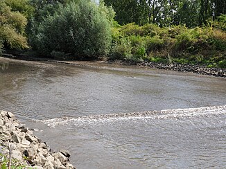
Mouth of the Käsbach in the Kostheim Main Harbor. The Käsbach has deposited vast amounts of very fine silt-like sediments in the harbor basin, which are carried on by constant, tidal fluctuations in the water level and cause the water level to run out very flat. The picture shows an accumulating flood. The fluctuations are caused by the ship traffic passing the mouth of the harbor basin. |
||
| Data | ||
| Water code | DE : 24992 | |
| location |
Rhine-Main lowlands
|
|
| River system | Rhine | |
| Drain over | Main → Rhine → North Sea | |
| origin | on the eastern edge of the built-up area at the Erbenheim airfield 50 ° 2 ′ 35 ″ N , 8 ° 19 ′ 54 ″ E |
|
| Source height | approx. 133 m above sea level NHN | |
| muzzle | in the port basin of Mainz-Kostheim (district of Wiesbaden ) in the Main Coordinates: 50 ° 0 '12 " N , 8 ° 19' 1" E 50 ° 0 '12 " N , 8 ° 19' 1" E |
|
| Mouth height | approx. 82 m above sea level NHN | |
| Height difference | approx. 51 m | |
| Bottom slope | approx. 8.1 ‰ | |
| length | 6.3 km (with the second Käsbach ) | |
| Catchment area | 17.6 km² | |
| Discharge A Eo : 17.6 km² at the mouth |
MQ Mq |
58.6 l / s 3.3 l / (s km²) |
| Left tributaries | First Käsbach | |
| Big cities | Wiesbaden | |
| Small towns | Hochheim am Main | |
| Ports | Mainz-Kostheim harbor basin | |
The Käsbach is about six kilometers long, right and northern tributary of the Main . It is its last tributary before it flows into the Rhine about two kilometers later at the Mainspitze .
Surname
The part of the name " Käs " is possibly derived from mhd. Kes meaning swampy, broken terrain .
geography
course
The Käsbach rises, as the second Käsbach , on the eastern edge of the built-up area on the US military airfield Wiesbaden-Erbenheim. He is still collecting wastewater from a sewage treatment plant near the airfield.
Then it touches an area of pebbled quarry ponds with its left bank. At the Hochheim-Nord junction, it first crosses federal highway 40 and then federal highway 671 . A little further down the stream it unites on the western outskirts of Hochheim am Main with the First Käsbach and from there on only bears the name Käsbach .
While it is previously flowed through relatively flat terrain, it now flows in a southwest direction by a Käsbachtal incision with said small gardens , meadows and large fields . At the Thunder Mill he reached the eastern edge of the Wiesbaden district of Mainz-Kostheim .
There the Käsbach heads south, again crosses under the B 40 and the Frankfurt - Wiesbaden railway line, is routed underground through the former premises of Zellstoff Waldhof (now SCA ) and finally flows into the at the eastern end of the Mainz-Kostheim harbor basin Main as the last tributary, which reaches it about 2 kilometers before its own confluence with the Rhine.
Catchment area
The 7.6 km² catchment area of the Käsbach lies in the Main- Taunus foreland and in the Lower Main plain . It is drained via the Main and the Rhine to the North Sea.
It borders
- in the northeast and east to that of the main tributary Wickerbach
- in the southwest of that of the Königsbach
- and in the northwest to that of the Waschbach , which drains over the Salzbach into the Rhine.
Most of the area of the catchment area is used as arable land.
Character and dates
The Käsbach is a silicate middle mountain stream and a body of water III. Order.
Almost its entire length of the Käsbach is assigned to water quality class II-III (critically polluted).
See also
Individual evidence
- ↑ a b Topographic Map 1: 25,000 and Google Earth
- ↑ Water map service of the Hessian Ministry for the Environment, Climate Protection, Agriculture and Consumer Protection ( information )
- ↑ Hessian State Office for Environment and Geology: retention cadastre for the Käsbach river area (PDF; 93 kB)
- ↑ Water map service of the Hessian Ministry for the Environment, Climate Protection, Agriculture and Consumer Protection ( information )
- ↑ see The names of the waters of the Main-Taunus area by Marieluise Petran-Belschner
- ↑ Page no longer available , search in web archives: Type 5: Silicate low mountain range streams (PDF; 141 kB)
Web links
- Käsbach database WFD
- Retention register for the Käsbach river area, river area code number: 24992 (PDF file; 91 kB)
