
Königsberg (Ybbstal Alps)
| Koenigsberg | ||
|---|---|---|
 The Königsberg from the northwest (Grenzberger Kogel) |
||
| height | 1452 m above sea level A. | |
| location | Lower Austria , Austria | |
| Mountains | Ybbstal Alps , Northern Limestone Alps | |
| Dominance | 7.6 km → Gamsstein | |
| Notch height | 666 m ↓ at Kleinpromau | |
| Coordinates | 47 ° 47 '50 " N , 14 ° 51' 32" E | |
|
||

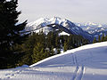
The Königsberg is a long ridge of the Göstlinger Alps in southwest Lower Austria , near the Upper Austrian border. It reaches an altitude of 1,452 m in the Schwarzkogel . There are some refuges for mountain hikers and a small ski area near Hollenstein for winter sports .
Location and landscape
The largely forested mountain range is about 15 km long. It rises between Hollenstein / Ybbs and Göstling an der Ybbs south of the Ybbstal, on which it offers beautiful views. The two main roads through the upper Ybbstal and the pass road that branches off at Göstling via Lassing and Palfau to the Ennstal ( Hieflau ) circle the ridge on three sides, while its west side is touched by the Hollenstein-Sandgraben-Lassing side road. It is crossed from west to east by a rock step.
Of several peaks above 1400 m , two (including the Köthler Eck) are in the western part and two in the eastern part, namely the Durnhöhe ( 1439 m ) and the Schwarzkogel ( 1452 m ). The range of the geographic coordinates is between 47 ° 45 '- 47 ° 49' North and 14 ° 47 '- 14 ° 55' East.
Königsberg is also the name of a district in the northwest of Göstling, which stretches up the eastern slope interspersed with mountain meadows. A few kilometers down the valley (to the west), the flat northern slope of the ridge bears the name Königsbergau .
geology
The Königsberg as part of the Northern Limestone Alps is made up of sedimentary rocks .
The main ridge is preceded by a chain of hills to the north, which consist of Opponitz layers ( lime and Rauwacken ) and some of which slope steeply to the Ybbstal (Grenzberger Kogel, Thomasberger Kogel, Dörrkogel, Berger Kogel). To the south follows a zone with Lunzer layers , which is also noticeable in terms of landscape due to gently sloping meadows. The Lunz strata consist of sandstone and shale, and in places they also contain coal , which used to be mined to an economically significant extent. Further south, on the north slope of the main ridge, there is shell limestone and south of a larger fault, reef limestone and marly-chalky chalk sediments, among other things . The southern slope of the Königsberg is largely formed by main dolomite , before Opponitz layers, Lunzer layers and Wetterstein limestone follow towards the southern foot of the mountain . The southeastern part of the Königsberg belongs tectonically to the Göstlinger shed zone, here in places the Permian - Scythian Hasel Mountains come to light.
The north-eastern area of the Königsberg is characterized by the sliding of large clods of shell limestone.
North of the Durnhöhe there is a large landslide area, the "Kastner Gschlief".
View from the Durnhöhe over the western part of the Koenigsberg, in the background the Voralpe

The Kitzhütte on the Königsberg, in the background the Gamsstein


Paths, huts and sights
The Königsberg is traversed from west to east by a rock step and several hiking trails, including a long-distance hiking trail . Most of the climbs start from the Ybbstal (several from Göstling), while the south side has steep rocky slopes and deep ditches (large and small Höllgraben, Eis- and Schwarzbachgraben). In the summit region there are several hunting huts and alpine meadows with a beautiful view of the distance, as well as two managed alpine huts and refuges : Kitzhütte 1266 m , and Siebenhüttenalm at 1300 m . To the latter you can drive two thirds of the way from Göstling-Süd on a mountain road and start the footpath at the organic farmer Kurzck at 1020 m altitude.
Where the boundary in the west follows the Hammerbach , there used to be - in the heyday of local iron processing - some hammer mills and now a themed trail. A summit above this side valley is called Eisenspitz . In Mendlingtal there are old wooden pastures to visit.
See also
swell
- ^ Erich Thenius: Lower Austria. Geology of the Austrian federal states in brief individual representations. 2nd expanded edition, Vienna 1974, pp. 118f.
- ^ Geological map of the Republic of Austria 1: 50,000, published by the Federal Geological Institute, Vienna 1988, sheet 71 Ybbsitz