
Köthnitz
|
Köthnitz
City of Neustadt an der Orla
Coordinates: 50 ° 41 ′ 25 ″ N , 11 ° 49 ′ 7 ″ E
|
|
|---|---|
| Height : | 435 (435-450) m |
| Residents : | 89 (Jul 31, 2012) |
| Incorporation : | July 1, 1950 |
| Incorporated into: | Linda near Neustadt an der Orla |
| Postal code : | 07806 |
| Area code : | 036481 |
 View of the place
|
|
Köthnitz is a district of the city of Neustadt an der Orla in the Saale-Orla district in Thuringia .
location
Köthnitz is about twelve kilometers (as the crow flies ) north of the district town of Schleiz on the upper reaches of the Auma and on the L 2350 state road . Federal motorway 9 is barely two kilometers away . The highest point is the mountain ( 463.6 m above sea level ).
history

The place was first mentioned around 1074 as Chotizi , later the spelling of the place name changed to Kotenitz (1454) and Köttenitz (1528). During the Thirty Years War , the place was ravaged by the Swedes and burned down in 1640. Köthnitz was then divided between four owners (manors). In the 19th century, the place belonged to the Grand Duchy of Saxony-Weimar-Eisenach , district court district Auma, until the state of Thuringia was formed .
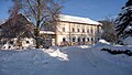
The village church was a branch church of Linda and, according to local tradition, dates from the 14th century; it was restored in 1826 and 1887. During the inventory of the monuments and art monuments in the 1890s, valuable wood carvings from the Romanesque period that had already been severely damaged by woodworms were discovered in the attic.
Culture and sights
- Köthnitz is an agricultural place on the edge of the recreation area Plothener Teiche . There is a village church in the local area.
- The forest festival in Köthnitz can already look back on over 85 years of tradition.

church

restaurant

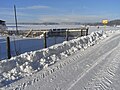
View of the wintry Köthnitz

Snow forest path
Outskirts


"Anno 1645"
Köthnitz 11


Web links
Individual evidence
- ^ Website of the community
- ^ Paul Lehfeld: Köthnitz . In: Georg Voss (Hrsg.): Architectural and art monuments of Thuringia. Grand Duchy of Saxony-Weimar-Eisenach. Auma District Court . tape V . Gustav Fischer Verlag, Jena 1897, p. 210-211 .
- ^ Website of the community
Arnshaugk | Börthen | Breitenhain-Strößwitz | Bucha | Döhlen | Dreba | Knau | Kleina | Köthnitz | Lichtenau | Linda near Neustadt an der Orla | Moderwitz | Molbitz | Neunhofen | Neustadt an der Orla | Poses | Sachsenburg | Stanau | Stone bridges