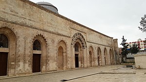
Kızıltepe
| Kızıltepe | ||||
|
||||
| Basic data | ||||
|---|---|---|---|---|
| Province (il) : | Mardin | |||
| Coordinates : | 37 ° 12 ' N , 40 ° 35' E | |||
| Residents : | 135,145 (2010) | |||
| Telephone code : | (+90) 482 | |||
| Postal code : | 47440 | |||
| License plate : | 47 | |||
| Structure and administration (as of 2012) | ||||
| Mayor : | Ferhan Türk ( BDP ) | |||
| Website: | ||||
| Kızıltepe County | ||||
| Residents : | 232,628 (2014) | |||
| Surface: | 1,416 km² | |||
| Population density : | 164 inhabitants per km² | |||
| Kaymakam : | Erkan Yırık | |||
| Website (Kaymakam): | ||||
Kızıltepe ( German Red Hill ; Kurdish : قوجحصار Qoçhisar or قۆسەر Qoser , Arabic دُنَيصَر, DMG dunaīṣar orتل أرمن, DMG tal ʾārmin 'hill of the Armenians') is a city and at the same time the name of the administrative unit İlçe (district) in the Turkish province of Mardin in southeastern Anatolia . The city of Kızıltepe has 135,145 and the district 212,905 inhabitants (as of 2010). Kızıltepe is located in the southwest of the province and borders Syria and the province of Şanlıurfa . In addition to Kızıltepe, the places Şenyurt, Gökçe, Dikmen and Yüceli also have the rank of commune (tr. Belediye ). There are also 160 villages and 70 hamlets in the district.
Kızıltepe was formerly called Koçhisar and was called "Kosar" by western chroniclers.
Individual evidence
- ↑ Turkish Institute for Statistics ( Memento from December 5, 2012 in the web archive archive.today ), accessed on January 22, 2012.
- ↑ http://www.webcitation.org/6WFDKzgrn , accessed March 5, 2018.
- ↑ D. Sourdel in: Encyclopaedia of Islam. New Edition. sv DUNAYSIR


