
Kaiser-Wilhelm-Ring (Cologne)
Kaiser-Wilhelm-Ring is the street name of a 771-meter-long section of the Cologne Rings , which runs between Hohenzollernring and Hansaring in Cologne's Neustadt-Nord .
Founding period
The city wall originally ran along Kaiser-Wilhelm-Ring , after which it was demolished on June 11, 1881 at the level of the Gereonstore, and the city began with the systematic demolition of the remaining sections. The open space left by the wall provided space for a broad, boulevard-like street. According to the plans of the city architect Josef Stübben , the Ringstrasse in the section of the Kaiser-Wilhelm-Ring was widened to 65 meters and equipped with 25 meter wide green strips with garden parterre, fountain and monuments. The 0.55 hectare park was only created around 1895 by master horticulturalist Adolf Kowallekas a symmetrically structured jewelry system with geometric ornaments. Only the green strips on Theodor-Heuss-Ring, Sachsenring and Ubierring were similarly broad. A section of the Kaiser-Wilhelm-Ring is the widest street in Germany at 114 meters .
This section was named after the first German Kaiser Wilhelm I on May 4, 1882. It followed a homogeneous naming principle, since the individual sections of the rings were borrowed from German history and the history of the city . The opening of the Kaiser-Wilhelm-Ring, Hohenzollernring and Hohenstaufenring section took place on October 1, 1882. Kaiser Wilhelm I drove the completed ring route together with Mayor Hermann Becker and Stübben on September 25, 1884, Wilhelm II drove this route, named after his grandfather, on May 4, 1891. The sewer system on the rings was completed on November 11, 1885.
building
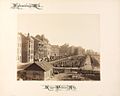
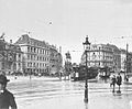
Kaiser-Wilhelm-Ring - city expansion, view east side (1886)

Kaiser-Wilhelm-Ring - city extension, view west side (1886)
Kaiser-Wilhelm-Ring 26–32 - residential building (around 1886)

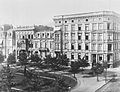
Kaiser-Wilhelm-Ring 1 - House on the corner of Hohenzollernring 95–101 (around 1887)

Kaiser-Wilhelm-Ring - from left to right No. 36 to No. 20 (around 1890)
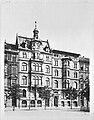
Kaiser-Wilhelm-Ring 18–20 - residential building (1891)

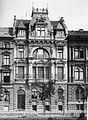
Kaiser-Wilhelm-Ring 23 / corner of Goebenstraße - Haus Raoul Stein (later Gothaer Versicherungsbank), around 1900
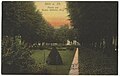
Kaiser-Wilhelm-Ring 29 - Park (around 1900)
Leyendecker House, Kaiser-Wilhelm-Ring 34

Kaiser-Wilhelm-Ring 38 - residential building (1888)
Kaiser-Wilhelm-Ring - corner of Christophstraße with equestrian statue of Kaiser Wilhelm I (around 1905)
Kaiser-Wilhelm-Ring - Postcard from June 10, 1907


One of the first buildings on the previously undeveloped ring route was the Meusersche Haus Kaiser-Wilhelm-Ring 32, completed by Atelier De Voss & Müller in 1885 . The same studio designed the neighboring house at Kaiser-Wilhelm-Ring 34 (1886). Architect Hermann Otto Pflaume built a tenement house in No. 14-18, which could be moved into in 1887. Plum, who had a decisive influence on the structural design of the Kaiser-Wilhelm-Ring, built his own house in 1887 at no. 14-18. Jean Schmitz completed No. 22 in 1888, and the neighboring No. 24 also came from Schmitz (1888). In the same year his apartment building at No. 29 / corner of Gladbacher Straße was ready for occupancy. Adolf Nöcker completed No. 38 in 1888, and No. 23 in the same year. Heinrich Wiethase built the tenement house in No. 3–5 from 1885–1889. In March 1886, negotiations began with the Protestant community about a piece of land; she finally acquired a representative site from Emdener Bank at Kaiser-Wilhelm-Ring / corner of Gladbacher Strasse 11. However, in May 1886 negotiations had to be conducted again about the expansion of this property with Pflaume and the entrepreneur Theodor Kyll, who owned the neighboring properties. After these negotiations failed, the city council decided on July 8, 1886, to give the Protestant parish a piece of land on Herwarthstrasse for the purpose of building the Christ Church .
Raoul Stein (1839–1904; partner in the banking house JH Stein ) and his wife Julinka Stein-Leiden had Pflaume build a magnificent villa at 23 Kaiser-Wilhelm-Ring in 1887/88. The Villa Schnitzler was built in 1890/91 in No. 17–19. Viktor Schnitzler was the owner of house no. 17-19 and was allowed - apparently with the permission of the widow Otto Andreae - who owned the house at Kaiser-Wilhelm-Ring 21 - to build the gasoline store for his cars on their property in 1913. Schnitzler moved to No. 21 in 1919. Eduard Linse's house for Emil vom Rath , built in No. 15 in 1890, had to be demolished in 1936. In 1891, Pflaume built a city palace at No. 31 for the Cologne entrepreneur Valentin Pfeifer , which was demolished in 1931 due to land speculation.
Monuments
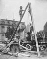
Kaiser-Wilhelm-Ring - Assembly monument to Kaiser Wilhelm I (May 1897)

Kaiser-Wilhelm-Ring - Inauguration of the equestrian statue of Wilhelm I on June 18, 1897
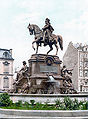
Kaiser-Wilhelm-Ring - Monument to Kaiser Wilhelm I (around 1900)

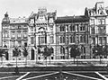
Kaiser-Wilhelm-Ring - Monument to Kaiser Wilhelm I (left Stadtpalais Pfeifer No. 31, right Hotel Kaiser Wilhelm No. 43 between Hermann-Becker-Straße and Hansaring), around 1910

Kaiser-Wilhelm-Ring - Father Rhine Fountain (1922)


As early as December 1889, the competition for a memorial representing Kaiser Wilhelm I was announced, which Richard Anders won in June 1890 . The city selected the northern part of the Kaiser-Wilhelm-Ring as the site of the monument, where a coffee house pavilion, which opened on September 3, 1887, still stood; he had to give way and was transferred to the Roman Park . The total height of the Kaiser monument was 10 meters, of which the statue reached 5 meters. Anders built the monument base on a planted rock area and surrounded it with a water basin. The inauguration of the 300,000 mark monument took place on June 18, 1897 in the presence of Wilhelm II and his wife Auguste Viktoria . The bronze statue showed the emperor with "a painterly draped coat, the command staff in his right hand, holding the horse and looking sideways into the distance". The small hotel-restaurant "Kaiser Wilhelm" at No. 43 stood in the background to match the monument. After the equestrian monument on the Hohenzollern Bridge, Cologne now had 2 Kaiser monuments, and on October 16, 1898 another followed on the banks of the Mülheim Rhine. For the Emperor's wife Auguste, a memorial was erected on October 1, 1903 at the southern end of the complex. The contract for the marble statue was placed in February 1899, the cost of which could not exceed 60,000 marks. The Cologne sculptors Franz Dorrenbach and Heinrich Stockmann won. The memorial was hit by bombs in 1943 and destroyed.
The stage-like fountain architecture with the reclining father Rhine and the four Rhine daughters of Adolf von Hildebrand was actually intended for Strasbourg in 1902. A suitable place was not found until 1920. After Hildebrand died in January 1921, the "Father Rhine Fountain" was erected on December 22, 1922 at the southern end of the facility. The fountain donated by factory owner Otto Andreae (1833–1910) who lived nearby did not survive long and was removed in 1939 because Hildebrand was Jewish.
The Gothaer Brunnen (“Fischbrunnen”), which stands on the site of the former “Father Rhine Fountain” and named after its sponsor Gothaer Versicherung , is 6.5 meters high and was built in 1971 by Elisabeth Baumeister-Bühler .
Modern times

Kaiser-Wilhelm-Ring 2–4 (April 2011)

Kaiser-Wilhelm-Ring 27–29 - Regus Business Center (July 2012)

Kaiser-Wilhelm-Ring 31–41 - Alliance (April 2010)
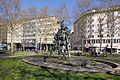
Kaiser-Wilhelm-Ring - "Gothaer-Brunnen" (April 2010)
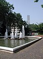
Kaiser-Wilhelm-Ring - fountain system (April 2010)

Kaiser-Wilhelm-Ring - green area (April 2010)
.jpg)

.jpg)
.jpg)

.jpg)
From February 17, 1902, the "Rundbahn" first traveled the Kaiser-Wilhelm-Ring from Barbarossaplatz via Unter Sachsenhausen and the Cologne brooks . Max Ernst lived in the attic of house number 14 from November 1918 until he moved to Paris in September 1922. The Westdeutsche Bodenkreditanstalt ("Westboden") moved into a new building in 1922 at No. 17-19, in 1928 it also acquired the adjacent property No. 21, on which the extension building planned by Jacob Koerfer was available from 1931. Karl Wach and Heinrich Roßkotten created a branch for Allianz insurance in No. 31–41 that was ready for occupancy in May 1933. She employed 640 people here, including 400 women. Fritz Spahn designed house No. 2-4, which was completed in 1936, and Theodor Merrill designed office building No. 15, which was ready for occupancy from 1937 onwards.
Immediately after the American invasion, the Kaiser-Wilhelm-Ring became the political center. the city. On March 9, 1945, just three days after the invasion, the new US military government under Colonel John K. Patterson moved into the barely destroyed office building at No. 2–4 and established its responsibility for the administrative district of Cologne . The first repair work on green spaces began as early as 1945 on Kaiser-Wilhelm-Ring directly in front of Allianz building No. 31-41, in which, from March 1945, the provisional Cologne City Hall was established. It was able to hold its first administrative conference here on March 30, 1945. On May 4, 1945, Konrad Adenauer moved in here as Cologne mayor . Since June 5, 1945, according to the Berlin Declaration, the British military administration was responsible for Cologne and moved into No. 2–4 after the Americans had vacated the building. The flag change took place on June 21, 1945 in front of the building. At the end of September 1945 she asked Adenauer to “cut down the trees in the green spaces and ring roads of Cologne in order to give the wood to the population as fuel.” After his refusal, there was a conflict between Adenauer and the British military administration. October 1945 led to his release. The Cologne police were also temporarily housed in No. 31–41 until they moved to Kattenbug on May 12, 1945. In May 1946, “Die Brücke” opened as a provisional facility as the first foreign cultural institute, set up by city commandant JM White on the ground floor of the Kaiser-Wilhelm-Ring 3–5 office building. The first Cologne Carnival Monday procession after the Second World War moved over the rings to the provisional town hall in the Allianz building on February 28, 1949.
Buildings No. 2–4 and No. 31–41 were the only ones to survive the enormous war damage on Kaiser-Wilhelm-Ring, where a lot of reconstruction work began in 1950. The German Central Bodenkreditbank ( "Central Ground") moved in 1951 its headquarters from Oldenburg in no. 27-29, built by Henry May, followed in 1951 Volkshilfe life insurance no. 46 West ground moved in 1952 in the reconstructed building in no. 17-21. After the Gothaer Versicherung was no longer allowed to operate in the Soviet-occupied Gotha due to the nationalization of the insurance industry in 1945, it moved its place of business to Cologne on March 5, 1946 and moved to "Gothaer Feuerversicherung" No. 23-25. It had relocated its headquarters here in 1943. The “Büro Bongers”, which was the founding plan for Lufthansa AG, moved into its offices in No. 20 on May 1, 1951. On May 25, 1951 , Hans Bongers was officially commissioned by the federal government to act as a consultant and expert on air traffic issues. Since April 15, 1952, the planning rooms have been at Claudiusstrasse 1 (at Römerpark ), even after the establishment of the “Aktiengesellschaft für Luftverkehrsbedarf” (“Luftag” for short) on January 6, 1953, the predecessor of today's Lufthansa AG stayed here until 15. April 1970.
The green space was restored in 1955 and reduced to 0.48 hectares. Only on January 2, 1956, the city administration moved from No. 31–41 to the “Spanish Building” of the not yet rebuilt Cologne City Hall . Allianz insurance moved back into the vacant building. After Berlin and Hamburg, Cologne ranked third in 1960 with the largest number of insurance companies in Germany, many of which resided on Kaiser-Wilhelm-Ring. On August 31, 1950, a first single-storey cinema building with 785 seats under the name "Residenz-Theater" was built on the ruins of the former Meuser house at Kaiser-Wilhelm-Ring 32. In 1959, the building was extended. On February 18, 1965, the “Intime Theater” with 365 seats also opened here on the upper floor. The cinemas were closed in December 2005 and used from October 2, 2009 to March 18, 2011 for the television show Die Oliver Pocher Show , and reopened on March 19, 2012 after extensive renovation under the name “Astor Film Lounge”.
On August 20, 1984, the Cologne City Council decided to redesign the western Ringstrasse according to the design by architects Ernst van Dorp / Klaus Schmidt / Gottfried Hansjakob / Paul Epping. These began with the redesign of the green area after the underground construction ended on October 31, 1987 with the opening of the Christophstrasse / Mediapark underground station in this area. They designed a 150-meter-long and 9-meter-wide water basin with fountains, fountains and way stars for the Kaiser-Wilhelm-Ring and based themselves on the Stübben plan from the Wilhelminian era. It was completed in 1989. Since May 2007, Regus , the world market leader for business centers , has had an office building in No. 27–29.
location
The Kaiser-Wilhelm-Ring begins on Bismarckstraße leading to the Belgian Quarter and ends at Hermann-Becker-Straße leading to the Mediapark . Further access roads are Goebenstrasse and Christophstrasse / Gladbacher Strasse. The Herwarthstrasse, which leads to the west, allows a view through the tower of the Christ Church near the city garden, as intended by the city planning . The Kaiser-Wilhelm-Ring is part of the federal highway 9 . It is served by the Cologne Stadtbahn with the Christophstraße / Mediapark underground station . Since October 1987, the green strip has no longer been used to separate the two directions of carriageway - as with the other ring sections - but both routes run without a median on the west side. On the east side of the Kaiser-Wilhelm-Ring there is a traffic-calmed access road
See also
Individual evidence
- ↑ Fred Kaufmann, Dagmar Lutz, Gudrun Schmidt-Esters: Cologne street names: Neustadt and Deutz. 1996, p. 74
- ^ Marion Werner: From Adolf-Hitler-Platz to Ebertplatz. 2008, p. 246
- ↑ Fred Kaufmann, Dagmar Lutz, Gudrun Schmidt-Esters: Cologne street names: Neustadt and Deutz. 1996, p. 74
- ↑ Eberhard Gothein, Georg Neuhaus: The city of Cöln in the first century under Prussian rule 1815 to 1915. Part 1, 1916, p. 230
- ↑ Gabriele Oeben-Domschky: Cologne economic citizen of the German Empire. 2003, p. 262
- ^ Association of German Architects (ed.): Cologne and its buildings. 1888, p. 699 f.
- ↑ Walther Zimmermann: The art monuments of the Rhineland. Volume 23, p. 189
- ^ Wolfram Hagspiel : Cologne and its Jewish architects. 2010, p. 377
- ↑ Walther Zimmermann: The art monuments of the Rhineland. Volume 23, p. 151
- ↑ Fred Kaufmann, Dagmar Lutz, Gudrun Schmidt-Esters: Cologne street names: Neustadt and Deutz. 1996, p. 75
- ^ Henriette Meynen: The Cologne green spaces. Volume 1, 1979, p. 19
- ↑ Iris Benner: Cologne Monuments 1871-1918. 2003, p. 125
- ↑ the monument was melted down in 1943
- ^ New series of publications by the Munich City Archives, Miscellanea Bavarica Monacensia. Volumes 163-164, 1993, p. 220
- ↑ Walther Zimmermann: The art monuments of the Rhineland. Volume 23, p. 151
- ↑ Gerald D. Feldman: Allianz and the German insurance industry 1933-1945. 2001, p. 151
- ↑ Alexander Kuffner: Time Travel Guide Cologne 1933-1945. 2009, p. 100
- ^ Hiltrud Kier , Ulrich Krings: Stadtspuren: Monuments Cologne. Volume 30, 2001, no p.
- ↑ Otto Dann: Cologne after National Socialism. 1981, p. 80
- ^ Andreas Brings: Whose friend and whose helper: the Cologne police under National Socialism. 2000, p. 582
- ↑ William L. Evenden: German Fire Insurance signs. 1989, p. 204
- ^ Handbook of German stock corporations . Volume 48, part 6, 1943, p. 5631
- ↑ Helmut Trunz: The story of Lufthansa: Aviation legend since 1926. 2008, p. 77
- ^ Georg Reul: Planning and founding of Deutsche Lufthansa AG 1949 to 1955. 1995, p. 63
- ↑ Walther Zimmermann: The art monuments of the Rhineland. Volume 23, p. 161
- ↑ Werner Baecker: Cologne: his buildings 1888-1988. 1991, p. 270
- ↑ Peter Fuchs (ed.): Chronicle of the history of the city of Cologne. Volume 2, 1991, p. 347
Coordinates: 50 ° 56 ′ 38 ″ N , 6 ° 56 ′ 29 ″ E