
Sachsenring (Cologne)

Sachsenring is the street name of the 1,714 meter longest section of the Cologne Rings , which runs between Brunostraße and Eifelstraße in Cologne's Neustadt-Süd .
Founding period
The city wall also originally ran along the Sachsenring , which is still visible through the 90-meter-long remains of the wall together with the Ulrepforte . After the demolition of the old city walls began on June 11, 1881 at the level of the Gereonstore , the city of Cologne also began the systematic demolition of the remaining sections. The open space left by the wall provided space for a broad , boulevard-like street. The Sachsenring, named on May 10, 1883 after the Saxon emperors (Ottonen), honors the German imperial families based on a proposal by city architect Josef Stübben . Cologne is closely linked to the Ottos, as Otto the Great made his brother Brun to Archbishop of Cologne and Duke of Lorraine. The wall area that became free created space for a 2.55 hectare green area laid out by Adolf Kowallek in 1884 . The deliberately planned, spacious green areas of the rings, especially on the Sachsenring, are visible from a bird's eye view. The sewer system on the rings was completed on November 11, 1885. The entrepreneur Franz Carl Guilleaume acquired the Ulrepforte and Kartäusermühle from the city of Cologne in 1885, had them restored by Vincenz Statz in 1886 and opened a catering business on June 11, 1886 on the 25,500 m² green area (Sachsenring No. 42) on an area of 769 m², of which 506 m² belonged to the fortress area, 186 m² to the Carthusian mill and 77 m² to the residential building. The Guilleaume family donated the land to the town in 1907.

Johann Heinrich Schoenscheidt - City expansion Cologne, Sachsenring systems (1886)
Sachsenring 32 - (1886)

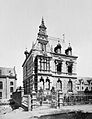
Sachsenring 77–79 - House Mallinckrodt / Scheibler (1886)

Sachsenring 74 (around 1890)

Sachsenring 20–22 - Architects Biecker & Böhm (1891)

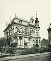
Sachsenring 48 - (1891)

Sachsenring 73 - Villa Arnold Guillaume (1897)

Sachsenring 73–75 / corner of Ulrichgasse, cut on the left Guilleaume House (around 1905)

Sachsenring 69 - Villa Grüneberg, 1900

Sachsenring - Pantaleonswall with the old Lutheran St. Johannis Church (1906) destroyed in World War II
Sachsenring 46 - to the right of the house, the Ulrepforte tower (1907)

Sachsenring 91–93 - Villa Hagen (1910)


The city of Cologne initially sold the land on Sachsenring from 1885 on the condition that only houses "that are free on at least three sides" were allowed to be built there. With this open construction, there were also front gardens that are still visible today. Besides the Theodor-Heuss-Ring, the Sachsenring is the only section of the ring with front gardens that underline the construction status of the villas standing here. Development began on Sachsenring in 1886, with a distinct villa area developing here. Mostly industrialists and bankers built their large villas on Sachsenring. One of the first villas was built in 1886 by Adolf Nöcker in Sachsenring No. 32 in the neo-renaissance style for the pensioner Melchior Froitzheim, who briefly rented it to Ludwig Stollwerck . Nöcker also built houses No. 28 and No. 30 in 1887. In 1886, Hermann Otto Pflaume in No. 77/79 provided the double house for Gustav von Mallinckrodt and Carl Johann Heinrich Scheibler with a garden completed on August 19, 1912 Friedrich Encke added. The pensioner Joseph Bartmann acquired the southern half of the double villa 84–86 from Magdeburger Bau- und Creditbank in 1886, the construction costs of which amounted to 34,000 marks. The city architect Stübben, who was responsible for planning the construction of the rings, moved himself into the detached half-villa No. 76 in the style of the German Renaissance in 1887. Alfred Müller-Grah was responsible for the villas in No. 78 and No. 80 in 1887. No. 81 was called Villa Hellmers and belonged to the co-owner of the saltpeter factory Traine & Hellmers , built in 1888 by Clemens Riffart.


The manufacturer Wilhelm Leyendecker moved into a villa built by Richard Dielmann at No. 75 in 1890, Otto March built the Villa Richard Grüneberg at No. 69 in 1892 ; a villa designed by Georg Eberlein in 1896 for the sawmill owner Isidor Dülken was at no. 49. The villa built by Ernst Eberhard von Ihne in 1897 for Arnold von Guilleaume at no. 73 was a U-shaped building open to Lothringer Strasse with a stable and a back Farm building by Franz Brantzky , Eugen Fabricius created 1903–1905 at No. 91–93 the Villa Louis Hagen . Villa Cramer-Nicolai was at number 48; Engineer Robert Siller, who owned numerous patents, had lived here since at least 1904. The nearby parish church of St. Paul was consecrated in 1908. The sculpture Diana with a jumping antelope standing on the median of the Sachsenring (at height no. 81–85) was initially installed in the Rheinpark in 1916 and was made by Fritz Behn .
Modern times
The Cologne business economist Eugen Schmalenbach bought No. 74 on November 12, 1931, after the previous owner (auctioned in April 1930) was no longer able to repay the mortgage in Schmalenbach's favor. On September 18, 1942, Schmalenbach brought the house into Treuhand AG, which he and his brother Hermann owned. From 1930, large villas were laid down on the Sachsenring and the land for apartment buildings was parceled out. The large-scale Peter and Paul attack on 28/29 in the Second World War created additional open spaces . June 1943, which largely destroyed the rings and their houses - including most of the villas in the Sachsenring; According to the official census, 4,377 people died.
The Federal Committee for Economic Education was housed in No. 38 since 1952. On January 15, 1953, the Institut français Cologne moved into the new building planned by Wilhelm Riphahn at No. 77 . In 1955–1957 Egon Eiermann built an administration building for Volkshilfe Lebensversicherung AG in No. 91, which is now its legal successor, AachenMünchener Lebensversicherung. In 1958 the Humboldt-Gymnasium in Cologne opened at the nearby Kartäuserwall 40. The Theater am Sachsenring has been located in No. 3 since 1986 , and No. 67 is the district association of the Social Association VdK Germany . No. 73a has housed the Cologne Theater Academy since 1997 . The Ulrepforte and the wall tower are used by the Cologne carnival associations Rote and Blaue Funken . A round glass building in no. 83–85, built in 1994 by Thomas van den Valentyn , has housed Horbach Wirtschaftsberatung since August 2002 .
location
From Brunostraße, the Sachsenring splits into a wide median ; With a width of more than 100 meters, it is one of the widest streets in Cologne, along with the Ubierring and Kaiser-Wilhelm-Ring . Its northern extension is the Salierring, southern the Karolingerring. Important road crossings are Vorgebirgstraße / Ulrichgasse, Overstolzenstraße and Eifelstraße. Ulrichgasse is part of today's north-south route . The tracks for lines 15 and 16 of the Cologne city railway are independent of traffic on the median, where there are the Ulepforte and - already on the Salierring - Eifelstraße stops . Bundesstraße 9 runs over the Sachsenring .
Web links
- stadtoasen-koeln.de - Issue 2: Sachsenring (history and redesign to accentuate historical substance and urban quality)
Individual evidence
- ↑ Fred Kaufmann / Dagmar Lutz / Gudrun Schmidt-Esters, Cologne street names: Neustadt and Deutz , 1996, p. 120
- ^ Theodor Rümpler, Illustrated Gartenbau-Lexikon , 1902, p. 425.
- ↑ Gabi Steinebach, The image of the city in the work of Jakob and Wilhelm Scheiner , 1992, p. 29
- ↑ Eberhard Gothein / Georg Neuhaus, The City of Cöln in the First Century under Prussian Rule 1815 to 1915 , Part 1, 1916, p. 230.
- ↑ Walther Zimmermann, Die Kunstdenkmäler des Rheinlands , Volume 23, 1978, p. 35.
- ↑ Heinz-Günther Hunold, Vom Stadtsoldaten zum Roten Funken , 2005, p. 81 ff.
- ↑ History seminar at the University of Cologne, History in Cologne , Volumes 37–40, 1995, p. 103.
- ↑ Petra Leser, Der Kölner Architekt Clemens Klotz, 1886-1969 , Volume 1, 1991, p. 30.
- ↑ Barbara Gemmersheim, Unternehmervillen der Kaiserzeit (1871-1914) , 1988, p. 233.
- ^ J. Becker, Blätter für Architektur und Kunsthandwerk , Volume 2, 1989, p. 23.
- ^ The Magdeburger Bau- und Creditbank acquired both properties from the city of Cologne in an auction in 1885
- ^ Eduard Trier / Willy Weyres, Art of the 19th Century in the Rhineland: Architecture II, Profane Buildings and Urban Development , 1979, p. 462.
- ^ Hiltrud Kier , The Cologne Neustadt. Planning, development, use , in: Contributions to the architectural and art monuments in the Rhineland, Volume 23, 1978, p. 197.
- ↑ Wolfram Hagspiel, Cologne: Architekturführer , 1999, p. 85.
- ^ Eduard Trier / Willy Weyres, Art of the 19th Century in the Rhineland: Architecture II, Profane Buildings and Urban Development , 1979, p. 531.
- ↑ Erich Potthoff , Günter Sieben : Eugen Schmalenbach: The man, his work, the effect , 1984, p. 170.
- ↑ Werner Baecker : Cologne: His buildings 1928–1988 , 1991, p. 70.
- ↑ Carl Dietmar: The night when the hillige Coellen went down. In: Kölner Stadt-Anzeiger , June 27, 2003; Andreas Otto ( KNA ): 73 years ago: "Peter and Paul attack" in Cologne. Sea of flames around the cathedral. In: Domradio.de , June 28, 2016.
Coordinates: 50 ° 55 ′ 25.6 ″ N , 6 ° 57 ′ 13.6 ″ E