
Kao (island)
| Kao | |
|---|---|
 Kao is the smaller island southwest of which lies Tofua |
|
| Waters | Pacific Ocean |
| Archipelago | Ha'apai |
| Geographical location | 19 ° 40 ′ 0 ″ S , 175 ° 2 ′ 0 ″ W |
 |
|
| length | 5.2 km |
| width | 3.2 km |
| surface | 11.6 km² |
| Highest elevation | Kao 1030 m |
| Residents | uninhabited |
| main place | Topuefio |
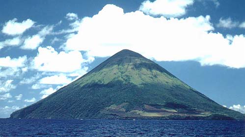
Kao is a small volcanic island in the South Pacific and part of the island state of Tonga . It is located in the western Ha'apai group and 3.4 km northeast of the larger neighboring island of Tofua . Kao is about 5 km long, 3 km wide and has an area of 11.6 km². The island consists of a volcanic cone rising steeply from the sea and is the highest point in Tonga with a height of approx. 1,030 m (1,046 m).
An eruption of the volcano has not yet been documented. However, since there are no signs of advanced erosion , the volcano must have been geologically active until recently. The lower slopes of Kaos are forested, while the upper part is bare.
The only slightly flatter area of the island is in the southwest, there is also the settlement of Topuefio . However, according to the 2006 census, there are no permanent residents.
Web links
Individual evidence
- ↑ UNEP
- ↑ a b Kao in the Global Volcanism Program of the Smithsonian Institution (English)
- ↑ a b Topographic map of Tofua and Kao (pdf, 1.2 MB)
- ↑ Census Tonga 2006 (pdf)
Niua Group : Niuafoʻou | Niuatoputapu | Tafahi
Vavaʻu group : Fonualei | Late | Toku | Vava'u
Ha'apai group : Fatumanongi | Foa | Fotuhaʻa | Ha'ano | Hakauata | Kao | Lifuka | Limu | Lofanga | Luahoko | Luangahu | Meama | Niniva | Nomuka | Nukupule | Ofolanga | Tofua | 'Uiha | Uoleva | Uonukuhahake
Tongatapu Group: ʻAta | ʻEua | Tongatapu
Disputed Area: Minerva Reefs