Foa (island)
| Foa | ||
|---|---|---|
| Map of the island of Foa | ||
| Waters | Pacific Ocean | |
| Archipelago | Ha'apai | |
| Geographical location | 19 ° 45 ′ 0 ″ S , 174 ° 18 ′ 0 ″ W | |
|
|
||
| length | 7.5 km | |
| width | 3.2 km | |
| surface | 13.39 km² | |
| Residents | 1479 (2006) 110 inhabitants / km² |
|
| main place | Faleloa | |
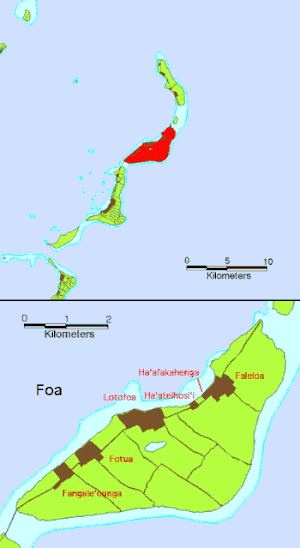
Along with Lifuka, Foa is one of the two main islands of Ha'apai , an archipelago belonging to Tonga . The coral island has an area of 13.39 km² and is connected to the neighboring island of Lifuka in the south by a 1 km long bridge.
The population increased from 1,434 to 1,479 between the 1996 and 2006 censuses. It is divided into six villages:
- Fakale'ounga (185)
- Fotua (300)
- Lofotoa (397)
- Faleloa (401)
- Ha'afakahenga (115)
- Ha'ateiho si'i (81)
The last two villages mentioned are with Faleloa are sometimes regarded as belonging to Faleloa, so that the result is also four villages on Foa.
Petroglyphs can be found throughout the island .
Web links
Individual evidence
- ↑ PDF at www.pmo.gov.to ( page no longer available , search in web archives ) Info: The link was automatically marked as defective. Please check the link according to the instructions and then remove this notice.


