Lifuka
| Lifuka | ||
|---|---|---|
| Maps of Lifuka and the surrounding area | ||
| Waters | Pacific Ocean | |
| Archipelago | Ha'apai | |
| Geographical location | 19 ° 49 ′ 0 ″ S , 174 ° 21 ′ 0 ″ W | |
|
|
||
| surface | 11.42 km² | |
| Residents | 2967 (2006) 260 inhabitants / km² |
|
| main place | Pangai | |
| Lifuka in Ha'apai | ||
Lifuka is next to Foa one of the two main islands of Ha'apai , an island group belonging to Tonga , as well as an administrative district. The coral island has an area of 11.42 km² and is connected to the neighboring island of Foa in the north by a 1 km long bridge.
The main town is Pangai , which is the largest settlement in the archipelago with 1,445 inhabitants. Other places are: Haatou, Tongoleleka, Holopeka and Koulo. Haatou and Tongoleleka have grown together with Pangai and form a settlement-geographic unit. On some maps, instead of the three villages, only the merged place appears under the name Lifuka.
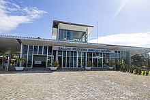
With the Lifuka Island Airport there is the only airport of Ha'apai in the north of the island.
In Pangai there is the grave of Shirley Waldemar Baker and a memorial commemorates him there.
The fortress Velata is said to have been in the south of the island, where George Tupou I defeated the Tuʻi Tonga Laufilitonga in 1826 .
In Tongoleleka there is a site from the Lapita culture .
Individual evidence
- ↑ Map of the Ha'apai Islands (PDF; 1.3 MB)
- ^ Tu'i Tonga - King of Tonga
- ↑ Lifuka
- ↑ Rapid prehistoric extinction of iguanas and birds in Polynesia (PDF; 144 kB)
- ↑ Tongoleleka Lifuka Iceland


