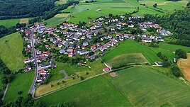
Kerbersdorf
|
Kerbersdorf
City of Bad Soden-Salmünster
Coordinates: 50 ° 19 ′ 56 ″ N , 9 ° 23 ′ 10 ″ E
|
|
|---|---|
| Height : | 279 m above sea level NHN |
| Area : | 3.31 km² |
| Residents : | 408 (1970) |
| Population density : | 123 inhabitants / km² |
| Incorporation : | 1st December 1970 |
| Incorporated into: | Salmunster |
| Postal code : | 63628 |
| Area code : | 06056 |
|
Kerbersdorf
|
|
Kerbersdorf is a district of Bad Soden-Salmünster in the Main-Kinzig district in East Hesse .
Geographical location
Kerbersdorf is located on the southern foothills of the Vogelsberg . The salt flows west past the place. The place borders clockwise to Sarrod , Marborn , Romsthal , Eckardroth and Katholisch-Willenroth .
history
The oldest surviving documentary mention as Korberstorf dates back to 1447.
Territorial reform
As part of the regional reform in Hesse , the municipality of Kerbersdorf in the district of Schlüchtern was incorporated into the city of Salmünster on December 1, 1970. 1 July 1974 at Bad Soden Salmünster force with the city state law to the new town of Bad Orb was merged and moved simultaneously in the newly formed Main-Kinzig-Kreis. For Kerbersdorf, a local district with a local advisory board and mayor was established.
Population development
Source: Historical local dictionary
| • 1812: | 42 fire places with 298 inhabitants |
| Kerbersdorf: Population from 1812 to 1970 | ||||
|---|---|---|---|---|
| year | Residents | |||
| 1812 | 298 | |||
| 1834 | 329 | |||
| 1840 | 366 | |||
| 1846 | 362 | |||
| 1852 | 383 | |||
| 1858 | 274 | |||
| 1864 | 316 | |||
| 1871 | 256 | |||
| 1875 | 303 | |||
| 1885 | 236 | |||
| 1895 | 221 | |||
| 1905 | 222 | |||
| 1910 | 219 | |||
| 1925 | 232 | |||
| 1939 | 226 | |||
| 1946 | 386 | |||
| 1950 | 346 | |||
| 1956 | 311 | |||
| 1961 | 302 | |||
| 1967 | 343 | |||
| 1970 | 408 | |||
| Data source: Historical municipality register for Hesse: The population of the municipalities from 1834 to 1967. Wiesbaden: Hessisches Statistisches Landesamt, 1968. Other sources: | ||||
Religious affiliation
Source: Historical local dictionary
| • 1885: | 6 Protestant (= 2.54%), 230 Catholic (= 97.46%) residents |
| • 1961: | 6 Protestant (= 1.99%), 296 Catholic (= 98.01%) residents |
Transport and infrastructure
Kerbersdorf is located on the national road 3178 between Sarrod and Romsthal.
There is a primary school in Kerbersdorf.
Web links
- Kerbersdorf district on the website of the city of Bad Soden-Salmünster.
- Kerbersdorf, Main-Kinzig district. Historical local dictionary for Hessen. In: Landesgeschichtliches Informationssystem Hessen (LAGIS).
- Literature about Kerbersdorf in the Hessian Bibliography
Individual evidence
- ↑ a b c d e f Kerbersdorf, Main-Kinzig-Kreis. Historical local dictionary for Hessen. (As of May 24, 2018). In: Landesgeschichtliches Informationssystem Hessen (LAGIS).
- ↑ Municipal reform in the district of Schlüchtern: 2.) Integration of the Kerbersdorf municipalities into the city of Salmünster on November 13, 1970 . In: The Hessian Minister of the Interior (ed.): State Gazette for the State of Hesse. 1970 No. 48 , p. 2254 , point 2254 ( online at the information system of the Hessian state parliament [PDF; 5,6 MB ]).
- ↑ Law on the reorganization of the districts of Gelnhausen, Hanau and Schlüchtern and the city of Hanau as well as the recirculation of the cities of Fulda, Hanau and Marburg (Lahn) concerning questions (GVBl. 330-26) of March 12, 1974 . In: The Hessian Minister of the Interior (ed.): Law and Ordinance Gazette for the State of Hesse . 1974 No. 9 , p. 149 , § 12 ( online at the information system of the Hessian state parliament [PDF; 3.0 MB ]).
- ^ Federal Statistical Office (ed.): Historical municipality directory for the Federal Republic of Germany. Name, border and key number changes in municipalities, counties and administrative districts from May 27, 1970 to December 31, 1982 . W. Kohlhammer, Stuttgart / Mainz 1983, ISBN 3-17-003263-1 , p. 376-377 .
