Eickumer Mühlenbach
|
Eickumer Mühlenbach ( Kinsbeke , Kinz (e) bach ) |
||
|
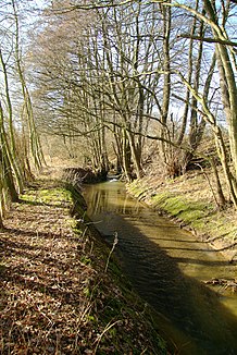
The Kinsbeke in Herford near the Diebrocker Friedhof |
||
| Data | ||
| Water code | EN : 4648 | |
| location | North Rhine-Westphalia , Germany | |
| River system | Weser | |
| Drain over | Aa → Werre → Weser → North Sea | |
| source | At Eickum / Oldinghausen 52 ° 6 ′ 45 ″ N , 8 ° 33 ′ 49 ″ E |
|
| Source height | approx. 130 m above sea level NN | |
| muzzle | At Herford in the Aa coordinates: 52 ° 6 ′ 21 ″ N , 8 ° 39 ′ 7 ″ E 52 ° 6 ′ 21 ″ N , 8 ° 39 ′ 7 ″ E |
|
| Mouth height | approx. 65 m above sea level NN | |
| Height difference | approx. 65 m | |
| Bottom slope | approx. 8.8 ‰ | |
| length | 7.4 km | |
| Catchment area | 19.3 km² | |
| Left tributaries | Asbeke , Lambach | |
| Right tributaries | Bremerhagener Bach , Heier-Mühlenbach | |
| Medium-sized cities | Herford | |
| Small towns | Tighter | |
The Eickumer Mühlenbach (also: Kinsbeke or Kinz (e) bach ) is a right tributary of the Aa in the northeast of the German state of North Rhine-Westphalia .
geography
The water has a total length of 7.4 km. The catchment area extends over a section of the Ravensberger Mulde west of Herford . The body of water rises near Oldinghausen on the border with Eickum and flows into the Johannisbach / Aa southwest of Herford city center (river kilometer 2.6). After the confluence of the Asbeke, the water is usually called Kinzbach, but officially the name is Eickumer Mühlenbach throughout.
The water flows through the following communities on its way from the source to the mouth:
On its way, the water includes the following waters when viewed downstream:
- Asbeke (L 3.7)
- Bremerhagener Bach (R 2.9)
- Lambach (L 2.3)
- Heier-Mühlenbach (R 1.1)
(L / R; KM): Left right inflow, at river kilometers, mouth at KM 0)
environment
About 5 km of the course of the stream - as well as the Asbeke and Lambach tributaries and meadows along the banks - are part of the Asbeke- / Kinzbachtal nature reserve and the Asbeketal NSG . Taken together, both form the third largest NSG in the Herford district. The area is formally under the protection of two nature reserves , which, however, naturally form a unit. 99.5 hectares of this are in the area of the Herford- Hiddenhausen landscape plan , 21 hectares in the area of the Enger - Spenge landscape plan . The valley is worth protecting because on the one hand it includes a distinctive sieve system typical of the Ravensberger Land , and on the other hand it is also a valuable habitat for flora and fauna in the middle of a densely populated area. The Siek is widely ramified and in places has a pronounced box profile with steps up to 10 m high. The damp Siekggrund with its meadows, reed beds, deciduous forests (especially alders , ash trees and oaks , individual laurel willows ) and numerous near-natural running and still waters are home to a large number of Red List plants and rare amphibians.
See also
Web links
- Nature reserve "Eickumer Mühlenbach" (HF-015) in the specialist information system of the State Office for Nature, Environment and Consumer Protection North Rhine-Westphalia for NSG Asbeketal
- Nature reserve "Eickumer Mühlenbach" (HF-016) in the specialist information system of the State Office for Nature, Environment and Consumer Protection North Rhine-Westphalia for NSG Asbeke-Kinzbachtal
- River information system


