Kirchenfeld (Wuppertal)
|
Kirchenfeld
City of Wuppertal
Coordinates: 51 ° 15 ′ 36 " N , 7 ° 3 ′ 50" E
|
||
|---|---|---|
| Height : | 190 m above sea level NHN | |
|
Location of Kirchenfeld in Wuppertal |
||
|
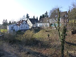
The oldest development on Kirchenfelder Weg
|
||
Kirchenfeld is a locality in the mountainous city of Wuppertal in the district of Vohwinkel .
Location and description
The location is at an altitude of 190 m above sea level. NHN on the Haßlinghauser ridge (Wuppertaler Nordhöhen) in the north of the residential quarter Schöller-Dornap in the Vohwinkel district . Neighboring locations are Klein Voisberg , Radenberg , Jammerhörnchen , An der Piep , Düsselerhöhe , Kirchenhöhe , Wieden and Tillmannsdorf , Brühl , Düssel and Voisberg in the neighboring municipality of Wülfrath in the Mettmann district . Gruitingschickenberg , Fredenschickenberg and Vossbeck fell through limestone mining in the 1960s.
The etymological meaning of Kirchenfeld has not yet been proven.
South of the oldest buildings of the church field Tillamnsdorfer trench in the beginning of the church fields Siefen westward into the Düssel flows . The source of the Kirchenfelder Bach is north of Kirchenfeld.
history
On the topographical survey of the Rhineland from 1824, a place is not recorded, only on the Prussian first survey of 1843 the place west of Brühl is recorded unmarked. At this time an old path leads from Brühl via Kirchenfeld to the west to the mean old path, today's Landesstraße 74 (in this section the Wiedener Straße ). The Wuppertal-Vohwinkel – Essen-Überruhr railway line , which was built between 1844 and 1847, lies between Brühl and Kirchenfeld ; the line can be crossed by an underpass to the south. After the Second World War, the area east of Kirchenfeld to Wiedener Strasse was opened up in the 1950s and 1960s with the construction of apartment buildings. The designation of the location as Kirchenfeld went over to the entire settlement area, which then dominated. Klein Voisberg has risen in Kirchenfeld. The streets Kirchenfelder Weg, Schopstreck and Am Kirchenfeld belong to the settlement .
Until 1974, the area around the Kirchenfeld belonged to Wülfrath, Unterdüssel district . The street with the name Kirchenfelder Weg , which can be found in continuation in the municipality of Wülfrath, was named for the first time on February 28, 1956. The name of the street Am Kirchenfeld took place on May 13, 1998.
Individual evidence
- ↑ Historical maps: Prussian new recording and Prussian first recording (on: HistoriKa25 , Landesvermessungsamt NRW, sheet 4708, Elberfeld).
- ↑ a b c Wolfgang Stock: Wuppertal street names. Their origin and meaning. Thales Verlag, Essen-Werden 2002, ISBN 3-88908-481-8 .

