
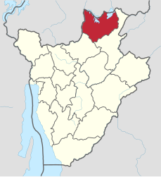
Kirundo (province)
| Kirundo | |
|---|---|
  |
|
| Basic data | |
| Country | Burundi |
| Capital | Kirundo |
| surface | 1,703.3 km² |
| Residents | 628,000 (calculation 2007) |
| density | 369 inhabitants per km² |
| ISO 3166-2 | BI-AI |
Coordinates: 2 ° 33 ' S , 30 ° 10' E
Kirundo or Kirundu is the northernmost province in Burundi and borders on Rwanda . Their capital is also called Kirundo .
The population density in 1990 was between 200 and 250 inhabitants per km². Kirundo has an area of 1,703.34 km² and a 2007 population of 628,000.
Agriculture and forestry is restricted to fishing in Rugwerosee and South Tschohoha Lake. Some coffee is grown to the southwest . Mineral resources southwest of the Rugweroseee are tungsten deposits.
Kirundo is divided into the seven districts of Bugabira , Busoni , Bwambarangwe , Gitobe , Kirundo, Ntega and Vumbi .