Biesnitz
|
Biesnitz
City of Goerlitz
Coordinates: 51 ° 8 ′ 13 ″ N , 14 ° 57 ′ 31 ″ E
|
|
|---|---|
| Height : | 220-420 m above sea level NN |
| Area : | 5.2 km² |
| Residents : | 3931 (Dec. 31, 2011) |
| Population density : | 756 inhabitants / km² |
| Incorporation : | October 1, 1951 |
| Postal code : | 02827 |
| Area code : | 03581 |
|
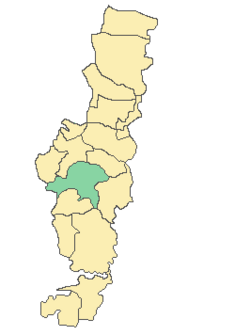
Location of Biesnitz in Görlitz
|
|
|
The Görlitz local mountain - the state crown
|
|
Biesnitz is a district of Görlitz that is predominantly characterized by single and multi-family houses and today extends between the foot of the Landeskrone in a north-easterly direction to the southern part of the city , and in a northerly direction to the Rauschwalde district . The main traffic artery, the Promenadenstrasse, leads to the small, winding streets, which are mostly named after famous German personalities such as Johann Sebastian Bach or the Scholl siblings . Mighty trees grow along the promenade and round off the peaceful appearance. Single and multi-family houses stand between all the green.
history
The first mention of Biesnitz 'was in 1015 together with the state crown in the chronicle of Thietmar von Merseburg . In this script it was referred to as "Businc", which was probably derived from the Besunzane who lived here at the time . The chronicle documents the capture of more than 1000 people and the conquest of the great Businc castle by Prince Ullrich.
The first documentary mentions can be found in 1315 as Bisent , Bisencz , Bysenth , Besint and Besenicz in the city book of Görlitz awarded in 1303.
Over time, the appearance has changed significantly. Little has been preserved of the original structure of the two and three-sided farmsteads. Many clinker brick buildings were built around the turn of the 19th and 20th centuries . Biesnitz has been connected to the city of Görlitz's tram network since 1897.
Biesnitz was divided into the two communities Klein Biesnitz and Groß Biesnitz. Both communities were incorporated into the city of Görlitz on October 1, 1951 and have since formed a Görlitz district.
In 1944, the Görlitz satellite camp was set up in Biesnitz . Today a memorial on Fröbelstrasse commemorates the prisoners, as well as a memorial stone in the Jewish cemetery to the Jewish prisoners murdered here. During the GDR era, a retirement home and a children's home as well as a deaconess mother house were built at the foot of the Landeskrone .
In the 1990s and 2000s, Biesnitz experienced accelerated structural densification, especially in the area between Grenzweg and Promenadenstraße. As a result, the demand for building land available or to be developed increased. Today the district is characterized by single and multi-family houses.
Attractions
The state crown is the symbol of the city of Görlitz. It is neither challenging to climb nor above average; however, the view over the city from its tower is worth every climb. The castle hotel with a panoramic view is located on the summit. If you still find the ascent too difficult, you can use the Landeskronen-Express, which goes from the terminus of tram line 2 to the Landeskrone. The few preserved old buildings offer the visitor architectural diversity - half-timbered upper floors, a wooden upper arbor and remains of half-timbered houses . In the direction of Weinhübel you can see the Oberhof, a four-sided courtyard with a tower at the manor house. At the time of the GDR this belonged to the state-owned Gut Kunnerwitz.
traffic
Biesnitz is connected to the transport network of the Görlitzer Verkehrsbetriebe :
- Tram line 2 to Königshufen / Am Wiesengrund
- City bus route F to Weinhübel via Kunnerwitz
- City bus route N to Rauschwalde / Diesterwegplatz (night traffic between 7 p.m. and midnight)
Web links
- Kleinbiesnitz in the Digital Historical Directory of Saxony
- Großbiesnitz in the Digital Historical Directory of Saxony
Individual evidence
- ↑ goerlitz.de: Statistical monthly figures for the city of Görlitz, December 2011 . (No longer available online.) Archived from the original on October 18, 2012 ; Retrieved June 11, 2012 . Info: The archive link was inserted automatically and has not yet been checked. Please check the original and archive link according to the instructions and then remove this notice.
- ↑ Federal Statistical Office (Ed.): Municipalities 1994 and their changes since 01.01.1948 in the new federal states . Metzler-Poeschel, Stuttgart 1995, ISBN 3-8246-0321-7 .


