
Small fort "on the book head"
| Small fort "on the book head" | |
|---|---|
| limes | ORL NN ( RLK ) |
| Route (RLK) | Upper German Limes, route 4 (Wetterau route) |
| Dating (occupancy) | unsure |
| Type | Small fort |
| unit | unknown |
| size | 10.65 × 12 m = 125 m² |
| Construction | Stone fort |
| State of preservation | visible ground monument |
| place | Limeshain -Rommelhausen |
| Geographical location | 50 ° 15 '37 " N , 8 ° 57' 41" E |
| height | 166 m above sea level NHN |
| Previous | ORL 20: Altenstadt Fort (northwest) |
| Subsequently | ORL 21: Fort Marköbel (south) |
The small fort "Auf dem Buchkopf" was a Roman fort on the Wetterau line of the Upper German-Raetian Limes near today's Rommelhausen, a district of the Limeshain municipality in the Wetterau district . A clear elevation of the ground is visible today from the complex, the fort is a ground monument .
location
The small fort was located roughly in the middle of the Limes line between the Altenstadt and Marköbel forts, west of the present-day town of Rommelhausen. The small fort was located at approximately the highest point of the Limes section. The now wooded area has ensured that the Limes structures are well preserved.
Fort
The fort is still visible today as a 1.50 m high hill behind the Limes wall. It had a size of 10.65 by 12 m, the slightly narrower side was oriented towards the Limes. “Auf dem Buchkopf” is one of the smaller, well-known small forts and was sometimes addressed as guard post 4/102.
The facility was examined in 1886 by the track commissioner Friedrich Kofler . He was able to determine the considerable thickness of the wall of 2.30 m, whereby the foundation on the east and south side had partially broken out and only traces of mortar were detectable. The foundation was still one meter deep on the preserved sides. The corners were rounded with a radius of 4.30 m. No further excavation results or finds are known.

Plan of the small fort based on the results of the RLK

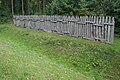
Right the Limeswall, sign, behind it left the 1.50 m high preserved hill of the small fort
Reconstructed Limes section on the country road


Limes course from the small fort "Auf dem Buchkopf" to Fort Marköbel
The Limes is clearly visible on the wooded section. For the most part, a path runs parallel to the end of the forest area near Langen-Bergheim, mostly in the ditch next to the wall. The route is provided with information boards. A section of the Limes has been reconstructed at the intersection with the L 3347. Further sights are the so-called Druse oak , which grows on the Limeswall. Her connection to the general Drusus is unknown, she is also likely to be considerably younger. Her name has already been proven at the time of the Reich Limes Commission. South of the forest, a memorial stone placed in 1912 (inscription "Pfahlgraben 1912") marks the point up to which the Limes was still visible before land consolidation. Further south to the Marköbel fort, the Limes runs through an area that is now used for agriculture or is partially built over in the area of the Hammersbach community . A section of the palisade is reproduced in Marköbel in a new building area, where stumps of the palisade have been archaeologically proven. The Limes is only visible again south of the Rückingen fort , where it enters the Bulau swamp area .
Limes line 4 (Taunus and Wetterau line) ends in Marköbel and line 5 (eastern Wetterau line) to the Großkrotzenburg am Main fort .
| ORL | Name / place | Description / condition |
|---|---|---|
| NN | Small fort "on the book head" | see above |
| Wp 4 / 102a | About 400 m south of the book head, suspected due to stone layers. | |
| Wp 4/103 | In the Eckartshäuser (Himbächer) Unterwald | Two wooden and one stone tower site (5.90 m side length) proven by excavations by the Reich Limes Commission. Information sign on site. The wooden tower point is marked by four posts and recognizable as a wall, as is a small hill in the stone tower. A reconstruction of the stone tower was completed in August 2013. |
| Wp 4/104 | supposed. | |
| Wp 4/105 | On the Druze oak | About 200 m south of the so-called Druze oak , two wooden tower sites and a stone tower detected during excavations in 1900 and 1902. The wooden towers had ring trenches twelve meters in diameter. The second wooden tower seems to have been rebuilt and a kind of barrack was built, from which a fireplace has been proven. Only later was a stone tower with a side length of 5.50 m between this and the pile built. Clear traces of the ramparts and ditches are still visible in the forest today. |
| Wp 4/106 | supposed | |
| Wp 4/107 | On the Mühlberg or Wingertsberg | supposed |
| ORL 21 | Fort Marköbel | see separate article Kastell Marköbel |


Monument protection
The small fort "Auf dem Buchkopf" and the facilities mentioned have been part of the Upper Germanic-Raetian Limes since 2005 as part of the UNESCO World Heritage . There are also ground monuments according to the Hessian Monument Protection Act . Investigations and targeted collection of finds are subject to approval, and accidental finds are reported to the monument authorities.
See also
literature
- Dietwulf Baatz , in: D. Baatz and Fritz-Rudolf Herrmann (eds.): The Romans in Hessen . 3. Edition. 1989. Licensed edition Nikol, Hamburg 2002, ISBN 3-933203-58-9 , pp. 409f.
- Dietwulf Baatz: The Roman Limes. Archaeological excursions between the Rhine and the Danube. 4th edition. Gebr. Mann, Berlin 2000, ISBN 3-7861-2347-0 , p. 167.
- Eduard Anthes , Friedrich Kofler and Wilhelm Soldan: stretches 4 and 5 (the Wetterau line from the Köpperner Tal near the Saalburg to the Main near Gross-Krotzenburg). The route description. In: Ernst Fabricius , Felix Hettner , Oscar von Sarwey (ed.): The Upper Germanic-Raetian Limes of the Roman Empire . Dept. A, Vol. 2, routes 4 and 5 ( The Wetterau line from the Köpperner Tal near the Saalburg to the Main near Gross-Krotzenburg ), 1936 pp. 148–151.
- Heide Birley and Vera Rupp : The Limes facilities at Limeshain-Rommelhausen, Wetteraukreis. Guide sheet to the archaeological and natural history hiking trail on the Pfahlgraben and to the prehistoric burial mounds . Wiesbaden 1996, ISBN 3-89822-131-8 (Archaeological Monuments in Hessen 131).
- Christian Fleer: Typification and function of the small buildings on the Limes. In: E. Schallmayer (Ed.): Limes Imperii Romani. Contributions to the specialist colloquium “Limes World Heritage Site” in November 2001 in Lich-Arnsburg. Bad Homburg v. d. H. 2004, ISBN 3-931267-05-9 , pp. 75-92 (Saalburg-Schriften 6).
- Jörg Lindenthal: Cultural Discoveries. Archaeological monuments in Hessen. Jenior, Kassel 2004, pp. 149f. ISBN 3-934377-73-4
Remarks
- ^ So in the route description of the Reichs-Limeskommission , ORL A 2, routes 4 and 5 (The Wetterau line from the Köpperner Tal near the Saalburg to the Main near Gross-Krotzenburg), 1936, p. 148.
- ^ Birley / Rupp 1996.
- ↑ ORL = numbering of the Limes structures according to the publication of the Reich Limes Commission on the O bergermanisch- R ätischen- L imes
- ↑ KK = unnumbered K linseed K astell.
- ↑ Wp = W oh p east, watch tower. The number before the slash denotes the Limes section, the number after the slash denotes the respective watchtower.
- ^ Parish Limeshain ( Memento from September 17, 2013 in the Internet Archive ); wayback
- ↑ ORL A 2 p. 149.
Lochmühle small fort | Kapersburg Castle | Small fort Ockstädter Wald | Small fort Kaisergrube | Small fort "Am Eichkopf" | Langenhain Castle | Small fort Hunnenkirchhof | Butzbach Castle | Small fort Degerfeld | Small fort Dicker Wald | Small fort in Holzheimer Unterwald | Small fort Hainhaus | Arnsburg Castle | Small fort Langsdorf | Feldheimer Wald small fort | Small fort "Auf dem Wingertsberg" | Inheiden Fort | Small fort Massohl | Small fort at the castle | Haselheck small fort | Echzell Castle | Lochberg small fort | Small fort Staden | Fort Ober-Florstadt | Small fort Stammheim | Altenstadt Castle | Small fort "on the book head"