
Small fort in Holzheimer Unterwald

| Small fort in Holzheimer Unterwald | |
|---|---|
| limes | ORL NN ( RLK ) |
| Route (RLK) | Upper German Limes, route 4 (northern part of the weather) |
| Dating (occupancy) |
Trajan period until the middle of the 3rd century |
| Type | Small fort |
| unit | unknown vexillatio |
| size | 18.60 m × 19.40 m = 0.036 ha |
| Construction | Stone fort |
| State of preservation | Foundation walls preserved and partially reconstructed |
| place | Langgöns and Pohlheim |
| Geographical location | 50 ° 29 '59.3 " N , 8 ° 41' 57.7" E |
| height | 248 m above sea level NHN |
| Previous | Small fort Dicker Wald (southwest) |
| Subsequently | Small fort Hainhaus (northeast) |
The small fort in Holzheimer Unterwald was a Roman border fort on the Wetterau line of the Upper German Limes , which has been a UNESCO World Heritage Site since 2005 . The former auxiliary fort is now a preserved and partially reconstructed ground monument in a wooded area of the Großen-Linden hill country north-west of the Wetterau towards the Lahn valley of the Giessen basin . It is located in the area of the town of Pohlheim in the Hessian district of Gießen , between the Pohlheim districts of Holzheim and Grüningen and the Langgöns district of Lang-Göns .
Historical background
Even at the beginning of the Roman attempts to occupy the Germanic areas on the other side of the Rhine , the Wetterau was in an exposed position. During the Drusus campaigns (12 to 9 BC) it was the staging area for the advance against the Chatti , which began in 10 BC. Started from the legionary camp Mogontiacum . In the Tiberian period , however, with the recall of Germanicus in 16 AD, the expansion efforts were initially stopped and the military facilities abandoned. For the next few decades the Rhine again formed the border between the Imperium Romanum and the Germanic tribal areas.
Only under Vespasian (69–79) was the region occupied again by the Romans and covered with a network of forts and road connections to secure the fertile Wetterau itself and the Main Valley . After the end of the Chat Wars (83-85) Domitians finally began the expansion of the Limes , which included the small fort "Holzheimer Unterwald". Initially consisting only of simple aisles cut into the forest , it has been increasingly expanded and reinforced since the Trajan times.
In the second half of the second century AD there was increasing Germanic pressure on the borders of the empire. This was also noticeable in the Wetterau, both in the form of smaller raids and heavy military advances, in the course of which the Limes was repeatedly overcome. Following the last major Germanic attacks in 259/260, the Romans finally cleared the area on the right bank of the Rhine and with it the Limes fort.
location


The small fortification is located directly on the Limes, in the small wooded area "Holzheimer Unterwald", a few meters west of the district road (K 162) from Grüningen, which joins the state road (L 3133) 200 m south, which connects Langgöns with Holzheim. It is a sight on the tourist German Limes Road . In front of the Limeswall, in the former Limes ditch, there is now a forest path that marks the boundary between Pohlheim and Langgöns.
In ancient times, the small fort was part of a section of the Upper German Limes that ran straight from southwest to northeast for over 8.5 km between the watchtowers Wp 4/33 (near Butzbach ) and Wp 4/49 (not far from the small fort Hainhaus ). Even if the straight course of the Limes did not take into account topographical conditions, the location of the fort seems to have been chosen with care. The occupation was probably responsible for monitoring the border traffic, which in the area of the pass used today by the L 3133 can be assumed in ancient times and possibly led directly through the fort in the early days. And from here there was a far-reaching view to the northwest in the direction of Lahn, which enabled effective apron monitoring and protection of the sensitive Limes arc, which was protruding to the north, on its northwest flank.
Research history
.jpg)
The “Holzheimer Unterwald” fort was first mentioned in writing in 1843 in the prehistory of the Wetterau , written by Johann Philipp Dieffenbach (Rector of the Friedberg Augustinian School and one of the most important regional archaeologists of his time) . From 1879, the first excavations , which were not carried out properly and were therefore incorrectly documented and misinterpreted, were carried out by Professor Carl Gareis from Giessen , a lawyer. Various ambiguities therefore led to follow-up examinations, which were carried out in 1894 by the Reich Limes Commission under the local direction of the route commissioner Friedrich Kofler .
Intensive predatory grave activity , which had taken place in the remote and therefore hardly controllable area since the beginning of the 1970s and which seriously threatened the existence of the ground monument, prompted the Archaeological Monument Preservation in the State Office for Monument Preservation of Hesse to carry out archaeological rescue excavations, which were carried out between 1988 and 1991 and below were led by Gabriele Seitz. In 1995 the facility was finally taken over by the Archaeological Society in Hessen e. V. carefully partially reconstructed and preserved.
Findings and interpretation


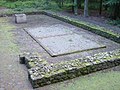
The small fort “Holzheimer Unterwald” is a stone fortification with an approximately rectangular floor plan. With sides of around 18.60 m by 19.40 m, it takes up an area of around 360 m², with an effective inner usable area of almost 290 m². At the time of its construction, the total space requirement including the trench in front was a little over 600 m², which corresponds to half an actus quadratus . With this area it is one of the smallest of its kind on the Upper German Limes. The investigations from 1988 to 1991 made it possible to differentiate between two construction phases, but not exactly dated them.
The fort was reinforced with an approximately 100 cm thick, double-shell wall made of basalt stones of regional origin . In contrast to most of the Limes forts, the corners of the defensive wall were not rounded, but rather sharp-edged. Immediately in front of the wall, separated from it only by a narrow berm , ran a two meter wide and one meter deep ditch. The front of the fortification was oriented to the northwest, towards the Limes. Here was a passage 2.50 m wide with 1.80 m long, retracted gate cheeks. The castle's only watchtower rose above the gateway. On the rear, south-eastern side, there was another entrance in the form of a slip gate only 1.20 m wide .
The interior of the fort was divided into two halves by a fortified camp alley, each with a half-timbered team barracks. Towards the camp alley , each barrack was preceded by a 1.50 m wide arcade . In each of these crew quarters, which were 13.80 m long and 3.60 m wide, there were four one- room contubernia (communal rooms ). The individual parlor shared an area of a good 12 m², within which people slept, cooked and ate. It is assumed that a maximum of four soldiers were accommodated per contubernium and that the total occupancy of the small fort was between 20 and 30 soldiers. It remains to be seen whether all of the rooms were actually used to accommodate the teams or whether some parts of them were also used to house mounts, since the state of the findings during the most recent excavations no longer made it possible to clarify the question of whether all rooms had a hearth.
In a more recent phase the fort was redesigned. The rear hatch was walled up, and the south-western team barracks were reduced by two rooms in the southern part. A well 9.50 m deep was dug in the undeveloped area obtained in this way. A square well shaft with a side length of 1.10 m was built into the circular excavation pit with a diameter of 2.0 m. The renovation measures speak for a reduced team strength, but possibly also for a changed self-image and self-confidence of the Limes troops. The need for security seems to have increased significantly, which is supported by the closure of the back of the fort and the safeguarding of the drinking water supply.
- Second construction phase

In the second construction phase, walled-in slip door (marked with white grout)
Second construction phase: well and floor plan of the south-western barrack with the two remaining Contubernia

Second construction phase: the situation of the changed floor plan in detail

View over the fort, which was reconstructed in the second construction phase, with the Limeswall in the background


Findings and dating
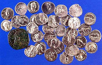
The most spectacular find from the fort is certainly the deposit of a small coin treasure consisting of a total of 35 coins, including 34 silver denarii and a sesterce made of a copper alloy. The series of coins begins with a minting by Vitellius from AD 69 and ends with a coin by Mark Aurel for his wife Faustina , which must have been minted in 176 at the latest. Further, a total of 14 individual coin finds consist of denarii, sesterces and aces of the emperors Vespasian , Trajan , Hadrian and Antoninus Pius . The oldest coin here also dates from 69, the latest was minted in 161.
The number of ceramics found was above average. In connection with the structural features of the fort, South Gaulish Terra Sigillata suggests that it was built in the Trajan period. Central and Eastern Gaulish terra sigillata from the pottery centers Augusta Treverorum ( Trier ) and Tabernae ( Rheinzabern ) attest to its continuous existence up into the first third of the third century. Isolated shards of rough-walled Urmitzer goods finally prove its existence in the second third of the century. The timing of the renovation can only be roughly estimated on the basis of the historical context. It probably falls during the time of the increasing threat from the Germanic peoples and the last expansion phase of the Limes. This would mean that it would be in the second half of the second century.
Another highlight of the finds is a shield hump of Germanic provenance, which, together with the finds of Germanic ceramics, documents the increasing presence of Germanic peoples in the Roman-occupied border area from the second half of the second century.
Nothing is known about the name and origin of the troops stationed in the “Holzheimer Unterwald”. Due to the distances involved, the auxiliary troops of Kastell Arnsburg and Kastell Butzbach can be used as detachment units for this vexillatio ( detachment ). Through so-called graffiti (name markings carved into the glossy coating of the Terra Sigillata vessels), with which the auxiliaries marked their personal eating utensils, the names of four soldiers have been preserved in fragments: MAT [ternus?], A VICT [or] or VICT [orinus] , a [----] IVS and a [----] VPI.
Limes course between the small fortifications Holzheimer Unterwald and Hainhaus
.jpg)

In its further course to the small fort Hainhaus up to the watchtower Wp 4/49, the Limes maintains the dead straight alignment that it recorded in Wp 4/37 in the Butzbach area and which over a distance of 8.5 km does not take any topographical conditions into account takes. Only after Wp 4/49 does it bend sharply to the east-north-east and draw in a weak arc towards the small fort Hainhaus, which it finally reaches facing completely east.
After the small fort in Holzheimer Unterwald, the pile ditch is still very well preserved in the wooded area for the next half kilometer. Where it then merges into the open arable land in the area of the presumed watchtower Wp 4/47, it becomes flatter, but is still perceptible as a terrain mark in the manner of a field . Up to the reconstructed Wp 4/49, however, only weak soil deformations can be seen from the towers. After crossing the state road 3132 (from Grüningen to Watzenborn-Steinberg) his traces are lost in the area.
| ORL | Name / place | Description / condition | ||||
|---|---|---|---|---|---|---|
| KK | Small fort in Holzheimer Unterwald | see above | ||||
| Wp 4/47 |
 |
|||||
| Wp 4/48 |
 .jpg) |
|||||
| Wp 4 / 48a |
Two hills about 35 m apart, where in 1896 the RLK found an increased amount of finds and a tower was located, but not excavated and documented. The 2005 prospecting confirmed the existence of a stone tower and also indicated a possible older wooden tower site. |
|||||
| Wp 4/49 | "On the Sandberg" |
Incorrect reconstruction of a stone tower (based on what we know from 1967), a little southwest of the authentic tower. The tower site is clearly perceptible in the terrain as a flat, 1.50 m high and 18.90 m diameter hill. The Reichs-Limeskommission found a square stone tower with a side length of 5.90 m 15 m behind the crest of the Limeswall. The thickness of the walls was 90 cm.
|
||||
| KK | Small fort Hainhaus | see main article small fort Hainhaus |
.JPG)
.JPG)
.JPG)
.JPG)
.JPG)
.JPG)
Monument protection
The small fort in Holzheimer Unterwald and the surrounding Limes facilities have been part of the UNESCO World Heritage as a section of the Upper German-Raetian Limes since 2005 . In addition, they are ground monuments according to the Hessian Monument Protection Act . Investigations and targeted collection of finds are subject to approval, and accidental finds are reported to the monument authorities.
Trivia

The name of the large community formed in 1971 and today's city of Pohlheim goes back to a village named "Pfahlheim" (in dialect "Pohlheim" or "Pfuhlheim") in the area of the community, which was mentioned as Falheim in 793 in the Lorsch Codex , but which went under in the Middle Ages . This name in turn referred directly to the Limes (Pohl = pile = pile ditch). The reconstructed watchtower Wp 4/49 became part of the newly created city arms. The name of the Pohl-Göns located a few kilometers south of the Limes (1250 as "Palgunsin") also goes back to the pile ditch.
In the immediate vicinity of the reconstructed watchtower is the so-called “ barbarian stone”, a memorial stone that Robert Sommer, the director of the Giessen psychiatry, had erected at this point together with his wife in 1912 to commemorate the course of the Roman Limes.
The small fort is the station of the Pohlheim Limes Hike, which has been taking place annually since 2006 .
See also
literature
- Dietwulf Baatz : The Roman Limes. Archaeological excursions between the Rhine and the Danube. 4th edition, Gebr. Mann, Berlin 2000, ISBN 3-7861-2347-0 , pp. 154-156
- Dietwulf Baatz: Limes. Northern weather route (district of Giessen) . In: Dietwulf Baatz and Fritz-Rudolf Herrmann: The Romans in Hessen. Licensed edition of the 1982 edition, Nikol, Hamburg 2002, ISBN 3-933203-58-9 , pp. 403-405
- Manfred Blechschmidt, Norbert Kissel, Ewald Seidler: Life in an archaeological monument on the Open Monument Day 2003. "Reconstruction" of the small Roman fort in Holzheimer Unterwald near Pohlheim-Holzheim, Gießen district , Hesse-Archeology, Volume 2003 (2004), ISSN 1610- 0190 , pp. 110-113
- Christian Fleer: Typification and function of the small buildings on the Limes. In: E. Schallmayer (Ed.): Limes Imperii Romani. Contributions to the specialist colloquium “Limes World Heritage Site” in November 2001 in Lich-Arnsburg. Bad Homburg v. d. H. 2004, ISBN 3-931267-05-9 , pp. 75–92, especially p. 78 (Saalburg-Schriften 6)
- Fritz Rudolf Herrmann, Gabriele Seitz: From prehistory to the Middle Ages. Archaeological excursions in the Wetterau. Guide sheet to the excavation sites Ringwall Glauberg, Kastell Holzheimer Unterwald, Burgwüstung Arnsburg . 2nd, supplemented edition, State Office for Monument Preservation Hessen, Wiesbaden 1993, ISBN 3-89822-084-2 (Archaeological Monuments in Hessen, 84)
- Margot Klee: The Roman Limes in Hessen. History and sites of the UNESCO World Heritage. Pustet, Regensburg 2009, ISBN 978-3-7917-2232-0 , pp. 130-135
- Margot Klee: The Limes between Rhine and Main. Theiss, Stuttgart 1989, ISBN 3-8062-0276-1
- Vera Rupp , Heide Birley: Hikes on the Wetteraulimes. Archaeological hikes on the Limes from the Köpperner Tal in Taunus to the Drususeiche near Limeshain . Theiss, Stuttgart 2005, ISBN 3-8062-1551-0 (Guide to Hessian Prehistory and Early History, 6)
- Egon Schallmayer : Geophysical prospection on the Limes in Hesse . In it: Wp 4/47 “West of point 273.4 NN”, Wp 4/48 “Im Krötenpfuhl” and Wp 4 / 48a “Vor dem Hengel” near Pohlheim-Grüningen, Gießen district . In: Andreas Thiel (ed.): New research on the Limes . Theiss, Stuttgart 2008, ISBN 978-3-8062-2251-7 , (Contributions to the Limes World Heritage Site, 3), pp. 71–73.
- Gabriele Seitz: New research on the northern Wetterau Limes. The Holzheimer Unterwald fort . In: Wetterau history sheets . 40, 1991, Bindernagel, Friedberg 1991, ISSN 0508-6213 , pp. 235-244
- Gabriele Seitz: The Holzheimer Unterwald fort: A small fort on the northern Wetteraulimes near Pohlheim-Holzheim, Giessen district . State Office for Monument Preservation Hessen, Wiesbaden 1999, ISBN 3-89822-133-4 (Archaeological Monuments in Hessen, 133)
Excavation reports of the Reich Limes Commission
- Ernst Fabricius , Felix Hettner , Oscar von Sarwey (ed.): The Upper Germanic-Raetian Limes of the Roemerreiches / Department A, Volume 2. The routes 4 and 5. The Wetterau line from the Köpperner Tal near the Saalburg to the Main near Gross-Krotzenburg . Petters, Heidelberg, Berlin and Leipzig, 1936.
Web links
- Literature about small fort Holzheimer Unterwald in the Hessian Bibliography
- Small fort in Holzheim , limes-pohlheim.de
- Small fort in Holzheimer Unterwald on Stefan Dornbusch's private Limes project page
- World Heritage Limes on the official website of the State Office for Monument Preservation Hesse with a complete, downloadable Limes development plan Hesse (pdf, 248.50 MB, 650 pages; Limes route Wp 4/47 to 4/49 p. 484–487, fort p. 494–495)
Remarks
- ↑ Vera Rupp: The Wetterau in Roman times. An introduction . In: Wetterauer Geschichtsblätter , 40, 1991, pp. 207-216. Bindernagel, Friedberg 1991, ISSN 0508-6213 .
- ↑ Vera Rupp, Heide Birley: Walks on the Wetteraulimes. Archaeological hikes on the Limes from the Köpperner Tal in Taunus to the Drususeiche near Limeshain . Theiss, Stuttgart 2005, pp. 26-39.
- ↑ Wp = W oh p east, watch tower. The number before the slash denotes the Limes section, the number after the slash denotes the respective watchtower.
- ↑ a b Gabriele Seitz: New research on the northern Wetterau Limes. The Holzheimer Unterwald fort . In: Wetterau history sheets . 40, 1991, Bindernagel, Friedberg 1991, p. 239.
- ↑ a b Gabriele Seitz: The Holzheimer Unterwald fort: A small fort on the northern Wetterau Limes near Pohlheim-Holzheim, Giessen district . State Office for Monument Preservation Hesse, Wiesbaden 1999, p. 10.
- ^ Johann Philipp Dieffenbach: On the prehistory of the Wetterau, at the same time as a contribution to antiquity . Leske, Darmstadt 1843, p. 147.
- ↑ Official website of the Archaeological Monument Preservation in the State Office for Monument Preservation Hesse.
- ↑ Official website of the Hesse Monument Preservation .
- ↑ The southwestern small fort "Dicker Wald" has the same design features.
- ↑ The Reichs-Limeskommission had found a 4 m wide and 1.30 m deep weir ditch following a 35 cm wide berm. ORL A, Vol. II, 1, p. 102.
- ^ Anne Johnson : Roman forts of the 1st and 2nd centuries AD in Britain and in the Germanic provinces of the Roman Empire , Zabern, Mainz 1987, (Kulturgeschichte der antiken Welt, Vol. 37), ISBN 3-8053-0868- X . P. 226, the crews normally preferred running water, which, if necessary, was led into the camps from distant sources by means of water pipes.
- ^ Illustration of the coin treasure on Stefan Dornbusch's private Limes project page.
- ↑ Even by the Imperial Limes Commission, goods with relief decorations were drag. 37 (ORL A, Vol. 2,1, p. 222). The modern excavations confirmed this approach.
- ↑ The first three are documented by Gabriele Seitz: The Holzheimer Unterwald fort: A small fort on the northern Wetterau Limes near Pohlheim-Holzheim, Giessen district . State Office for Monument Preservation Hessen, Wiesbaden 1999, p. 12, the last in the publication of the Reichs-Limeskommission (ORL A, vol. 2,1, p. 222).
- ↑ ORL = numbering of the Limes structures according to the publication of the Reich Limes Commission on the O bergermanisch- R ätischen- L imes
- ↑ KK = unnumbered K linseed K astell.
- ↑ At about 50 ° 29 '59.28 " N , 8 ° 41' 57.73" O .
- ^ A b c Egon Schallmayer : Geophysical prospection on the Limes in Hesse . In: Andreas Thiel (ed.): New research on the Limes . Theiss, Stuttgart 2008, ISBN 978-3-8062-2251-7 , (Contributions to the Limes World Heritage Site, 3), pp. 71–73.
- ↑ At about 50 ° 30 '34 " N , 8 ° 42' 27" O .
- ^ Ernst Fabricius, Felix Hettner, Oscar von Sarwey (ed.): The Upper Germanic-Raetian Limes of the Roemerreiches / Department A, Volume 2. The routes 4 and 5. The Wetterau line from the Köpperner Tal near the Saalburg to the Main near Gross-Krotzenburg . Petters, Heidelberg, Berlin and Leipzig, 1936, p. 104.
- ↑ a b c World Heritage Limes on the official website of the State Office for Monument Preservation Hesse with a complete, downloadable Limes development plan Hesse (pdf, 248.50 MB, 650 pages; Limes route Wp 4/47 to 4/49), pp. 484-487.
- ↑ At about 50 ° 30 '49.5 " N , 8 ° 42' 39.5" O .
- ↑ After Dietwulf Baatz: The Roman Limes. Archaeological excursions between the Rhine and the Danube. 4th edition, Gebr. Mann, Berlin 2000, pp. 157f. and Dietwulf Baatz: Limes. Northern weather route (district of Giessen) . In: Dietwulf Baatz and Fritz-Rudolf Herrmann: The Romans in Hessen. Licensed edition of the 1982 edition, Nikol, Hamburg 2002, p. 404f., It is too low due to a missing floor. In addition, the tiled roof was "un-Roman" and the walls were plastered. Criticism also from Vera Rupp, Heide Birley: Walks on the Wetteraulimes. Archaeological hikes on the Limes from the Köpperner Tal in Taunus to the Drususeiche near Limeshain . Theiss, Stuttgart 2005, p. 144.
- ↑ 50 ° 31 '3.64 " N , 8 ° 42' 49.65" O .
- ↑ Karl Josef Minst [transl.]: Lorscher Codex (Volume 5), Certificate 2966, November 4, 793 - Reg. 2433. In: Heidelberg historical stocks - digital. Heidelberg University Library, p. 40 , accessed on March 19, 2016 .
- ↑ Pohlheim Limes Hike, pohheim.de
Lochmühle small fort | Kapersburg Castle | Small fort Ockstädter Wald | Small fort Kaisergrube | Small fort "Am Eichkopf" | Langenhain Castle | Small fort Hunnenkirchhof | Butzbach Castle | Small fort Degerfeld | Small fort Dicker Wald | Small fort in Holzheimer Unterwald | Small fort Hainhaus | Arnsburg Castle | Small fort Langsdorf | Feldheimer Wald small fort | Small fort "Auf dem Wingertsberg" | Inheiden Fort | Small fort Massohl | Small fort at the castle | Haselheck small fort | Echzell Castle | Lochberg small fort | Small fort Staden | Fort Ober-Florstadt | Small fort Stammheim | Altenstadt Castle | Small fort "on the book head"