
Small fort Kaisergrube
| Small fort Kaisergrube | |
|---|---|
| limes | ORL - ( RLK ) |
| Route (RLK) |
Upper German Limes route 4 (western weather route) |
| Type | Small fort |
| size | 730 m² |
| Construction | a) wood b) stone |
| State of preservation | Ground monument with perceptible traces of the ground |
| place | Wehrheim-Friedrichsthal |
| Geographical location | 50 ° 20 '13.2 " N , 8 ° 38' 48.3" E |
| height | 409 m above sea level NHN |
| Previous | Small fort Ockstädter Wald (south) |
| Subsequently | Small fort "Am Eichkopf" (north) |

The small fort Kaisergrube was a Roman fort in the Upper German Limes , which was granted UNESCO World Heritage status in 2005 . The ground monument , of which only deformations in the ground can be seen today, is located in the western part of the Wetterau, east of Friedrichsthal , a district of the municipality of Wehrheim in the Hessian Hochtaunuskreis .
Location and description
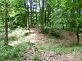
The name of the small fort is derived from the adjoining Alte Kaisergrube mine , which is now closed. Some of its spoil heaps also cover the area of the former Limes pile ditch, and the fort area was also severely disturbed by mining activities. Archaeologically, a total of two construction phases could be proven: the defense of the early wood-earth fort was built in the classic playing card shape with rounded corners. In front of the wall, a weir ditch surrounded the facility, which can still be seen in the south. The ramparts in stone were converted later. The interior development probably consisted of simple half-timbered barracks during both construction phases.

Wall crown of the small fort Kaisergrube
Wall systems of the small fort


Limes course between the small fort Kaisergrube and the small fort "Am Eichkopf"
| ORL | Name / place | Description / condition |
|---|---|---|
| KK | Small fort Kaisergrube | see above |
| Wp 4/16 | Gaulskopf | Position of a stone watchtower, which may have a line of sight to the signal tower 6.5 km away on the Johannisberg in Bad Nauheim. From there, the signals could be forwarded to the nearest Friedberg Fort . The tower had a massive buttress foundation. It was probably a particularly tall signal tower. A wooden predecessor building could not be found on the Gaulskopf because the older Limes line ran further to the east. From the Gaulskopf you have a good view of the northern Wetterau, along the Limes to the northeast and the Taunus ridge in the southeast. In addition to the original location, a replica of the tower, which is considered to be one of the best watchtower reconstructions on the Limes, was inaugurated in 1926 over a three-year construction period. Presumably the original tower should have been a little higher. The construction was made possible by donations from the stocking manufacturer Gustav Oberlaender . His commitment is acknowledged on the tower by a Latin inscription.
|
| Wp 4/17 | Due to the distance between Wp 4/16 and Wp 4/18 suspected but archaeologically not proven tower site | |
| Wp 4/17 * | " At the ant's head " | Tower site with two wooden towers |
| Wp 4/18 | Vogeltal | Stone tower hill. During the excavation by the Reichs-Limeskommission , a bronze mouthpiece of a wind instrument ( tubae ) was recovered, which probably once served as a horn. |
| Wp 4/19 | " At the Eichkopf " | Presumed, but archaeologically not proven tower site. |
| KK | Small fort "Am Eichkopf" | see main article small fort "Am Eichkopf" |


Monument protection
The small fort Kaisergrube and the adjoining watchtowers were added to the UNESCO World Heritage List in 2005 as part of the Upper Germanic-Rhaetian Limes . They are ground monuments within the meaning of the Hessian Monument Protection Act . Investigations and targeted collection of finds are subject to approval, and accidental finds are reported to the monument authorities.
See also
literature
- Dietwulf Baatz and Fritz-Rudolf Herrmann (eds.): The Romans in Hessen . 3. Edition. 1989. Licensed edition Nikol, Hamburg 2002, ISBN 3-933203-58-9 , p. 346.
- Dietwulf Baatz: The Roman Limes. Archaeological excursions between the Rhine and the Danube. 4th edition. Gebr. Mann, Berlin 2000, ISBN 3-7861-2347-0 , pp. 142-145.
- Christian Fleer: Typification and function of the small buildings on the Limes. In: Egon Schallmayer (Ed.): Limes Imperii Romani. Contributions to the specialist colloquium “Limes World Heritage Site” in November 2001 in Lich-Arnsburg. Bad Homburg v. d. H. 2004, ISBN 3-931267-05-9 (Saalburg-Schriften 6), pp. 75-92.
- Margot Klee : The Roman Limes in Hessen. History and sites of the UNESCO World Heritage. Verlag Friedrich Pustet, Regensburg 2009, ISBN 978-3-7917-2232-0 , pp. 109-112.
- Margot Klee: The Limes between Rhine and Main. From the beginning of the Upper German Limes near Rheinbrohl to the Main near Grosskrotzenburg. Theiss, Stuttgart 1989, ISBN 3-8062-0276-1 , pp. 86-89.
- Charles-Marie Ternes : The Provincia Germania Superior in the picture of the younger research. In: Hildegard Temporini, Wolfgang Haase (Hrsg.): Rise and decline of the Roman world . Series II, Volume 5, 2. de Gruyter, Berlin 1976, p. 798.
- Vera Rupp , Heide Birley: Hikes on the Wetteraulimes. Archaeological hikes on the Limes from the Köpperner Tal in Taunus to the Drususeiche near Limeshain . Theiss, Stuttgart 2005, ISBN 3-8062-1551-0 , (Guide to Hessian Pre- and Early History, 6), pp. 72–83.
Excavation reports of the Reich Limes Commission:
- Ernst Fabricius , Felix Hettner , Oscar von Sarwey (ed.): The Upper Germanic-Raetian Limes of the Roman Empire / Abt. A, Vol. 2.1. Legs 3 to 5, leg 3 . Petters, Heidelberg / Berlin / Leipzig 1936, p. 151f. and panel 11, fig. 3.
- Ernst Fabricius, Felix Hettner, Oscar von Sarwey (ed.): The Upper Germanic-Raetian Limes of the Roman Empire / Abt. A, Vol. 2.1. Legs 3 to 5, leg 4 . Petters, Heidelberg / Berlin / Leipzig 1936, pp. 51–59 as well as plate 3, fig. 1–4.
Remarks
- ↑ ORL = numbering of the Limes structures according to the publication of the Reich Limes Commission on the O bergermanisch- R ätischen- L imes
- ↑ KK = unnumbered K linseed K astell.
- ↑ Wp = W oh p east, watch tower. The number before the slash denotes the Limes section, the number after the slash denotes the respective watchtower. An additional asterisk (*) refers to a guard on the older Limes line.
- ↑ 50 ° 20 '20.79 " N , 8 ° 38' 36.55" O .
- ↑ 50 ° 20 '20.8 " N , 8 ° 38' 36" O .
- ↑ 50 ° 20 '37.11 " N , 8 ° 38' 38.35" O .
- ↑ 50 ° 20 '36.14 " N , 8 ° 38' 38.96" O .
- ↑ 50 ° 20 '56.78 " N , 8 ° 38' 26.16" O .
- ↑ KK = unnumbered K linseed K astell.
Individual evidence
- ^ Britta Rabold, Egon Schallmayer , Andreas Thiel : The Limes, The German Limes Road from the Rhine to the Danube. Association of German Limes Street, K. Theiss Verlag, Stuttgart 2000, p. 45
Lochmühle small fort | Kapersburg Castle | Small fort Ockstädter Wald | Small fort Kaisergrube | Small fort "Am Eichkopf" | Langenhain Castle | Small fort Hunnenkirchhof | Butzbach Castle | Small fort Degerfeld | Small fort Dicker Wald | Small fort in Holzheimer Unterwald | Small fort Hainhaus | Arnsburg Castle | Small fort Langsdorf | Feldheimer Wald small fort | Small fort "Auf dem Wingertsberg" | Inheiden Fort | Small fort Massohl | Small fort at the castle | Haselheck small fort | Echzell Castle | Lochberg small fort | Small fort Staden | Fort Ober-Florstadt | Small fort Stammheim | Altenstadt Castle | Small fort "on the book head"