Gaulskopf (Taunus)
| Gaulskopf | ||
|---|---|---|
|
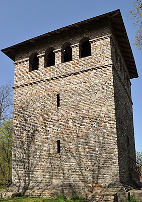
Roman tower on the Gaulskopf |
||
| height | 396.8 m above sea level NHN | |
| location | near Ober-Mörlen , Wetteraukreis , Hesse ( Germany ) | |
| Mountains | Taunus | |
| Dominance | 1.69 km → Winterstein | |
| Coordinates | 50 ° 20 '21 " N , 8 ° 38' 36" E | |
|
|
||
| particularities | Römerturm ( AT ) | |
The Gaulskopf near Langenhain-Ziegenberg in the Wetteraukreis in Hesse is 396.8 m above sea level. NHN high elevation in the Taunus low mountain range .
geography
location
The Gaulskopf is located in the eastern Hintertaunus . It rises in the Taunus Nature Park about five kilometers southwest of Ober-Mörlen (Wetteraukreis), on whose boundary it is located, and 3 km south of its district Langenhain-Ziegenberg . The Wehrheim districts of Pfaffenwiesbach in the west- south- west and Friedrichsthal in the west-north-west are around two kilometers away in the neighboring Hochtaunus district ; the border to this district runs over the western flank of the Gaulskopf. To the north the landscape slopes down to the valley of the Usa weather tributary .
Natural allocation
The Gaulskopf belongs to the natural area main unit group Taunus (No. 30) and in the main unit Eastern Hintertaunus (302) to the natural area Münster-Maibach-Schwelle (302.4). Southwest, the natural environment includes Usinger pool (302.5) and the southeast to the main unit in the High Taunus (301) belonging subunit Winterstein-Taunus ridge (301.4) is a part of the Taunus main ridge .
Roman tower
The Limes used to run over the Gaulskopf, on which the Roman watchtower WP 4/16 (numbering of the Imperial Limes Commission ) was located. Standing on the summit area, the tower offered a panoramic view of the surrounding Taunus heights of the eastern Hintertaunus and the Wetterau . There was an optical connection to Fort Friedberg via the watchtower on Johannisberg . Similar towers, which probably belonged to a signal chain, existed at Wölfersheim - Wohnbach and at Kapellenberg near Hofheim am Taunus . The tower on the Gaulskopf was located between the small fort “ Kaisergrube” and the small fort “Am Eichkopf” (see list of forts on the Upper German-Raetian Limes ). Today the Limes Experience Trail Hochtaunus follows the course of the Limes over the Gaulskopf.
The present reconstruction of the Roman tower was inaugurated in 1926. Only ruins remained of the original tower. The reconstruction was carried out with funds from Gustav Oberlaender (June 2, 1867 to November 30, 1936), a German stocking entrepreneur from the USA. The 15.1 m high tower is unusually large with a side length of 8 m. A total of 47 steps lead over an intermediate floor to the closed viewing platform at a height of 8.8 m , which allows a view of the surroundings through 16 arched windows.
gallery
Monument protection and remains
As a section of the Upper Germanic-Rhaetian Limes, the Römerturm and the surrounding Limes have been part of the UNESCO World Heritage since 2005 . In addition, they are ground monuments according to the Hessian Monument Protection Act . Investigations and targeted collection of finds are subject to approval, and accidental finds are reported to the monument authorities.
See also
Individual evidence
- ↑ a b Map services of the Federal Agency for Nature Conservation ( information )
- ↑ Gaulskopf, Am Pfahlgraben on Geoportal Hessen (query parcel search)
- ↑ Brigitte Schwenzer: Geographical land survey: The natural space units on sheet 139 Frankfurt a. M. Federal Institute for Regional Studies, Bad Godesberg 1967. → Online map (PDF; 4.9 MB)
- ↑ Limes experience path Hochtaunus , on saalburgmuseum.de
- ↑ Height according to the building plan of the Roman tower on the Gaulskopf (12 m + 3.1 m = 15.1 m), on commons.wikimedia.org
literature
- Dietwulf Baatz in: D. Baatz and Fritz-Rudolf Herrmann (eds.): The Romans in Hessen³ . Licensed edition of the 1989 edition, Nikol, Hamburg 2002 ISBN 3-933203-58-9 , p. 399.
- Vera Rupp and Heide Birley: Hikes on the Wetteraulimes. Archaeological hikes on the Limes from the Köpperner Tal in Taunus to the Drususeiche near Limeshain. Theiss, Stuttgart 2005, ISBN 3-8062-1551-0 (= Guide to Hessian Pre- and Early History 6), pp. 98-100
Web links
- Summit in the Taunus for dominance and prominence , on thehighrisepages.de


