
Settlement history Kapellenberg (Taunus)
| Ring wall Kapellenberg | ||
|---|---|---|
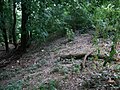
 The north wall with the present ditch |
||
| Alternative name (s): | Celtic wall | |
| Creation time : | Neolithic | |
| Conservation status: | Ground monument | |
| Place: | Hofheim | |
| Geographical location | 50 ° 5 '56.6 " N , 8 ° 26' 12.6" E | |
| Height: | 292 m | |
|
||

The settlement history of the Kapellenberg near Hofheim am Taunus goes back to the Neolithic . There was extensive settlement during the Michelsberg culture , which is evidenced by the large ring wall that can still be seen today . But Corded Ware grave sites or the remains of a Roman watchtower indicate the special position that the Chapel Hill for the settlement of the region in Hofheim had. Another important building is the chapel from the 17th century in the south of the plateau , which gives the Kapellenberg its name .
The buildings and sites on the Kapellenberg

The ring wall encloses most of the ridge. It is most noticeable in the northern area. On the basis of the investigations, two grave structures approximately in the middle of the ring wall can be assigned to the cord ceramic culture .
In the south are the remains of an early Roman watch and observation tower, which was surrounded by a protective ditch and from which one had a line of sight to the Hofheim fort , and a small circular hill with a diameter of about 60 m.
A chapel from the 17th century in the south near the mountain peak is named after the mountain ridge. Also in the center of the complex is the Meisterturm lookout point and to the south outside the wall of the Cohausen temple . A historical educational trail of around 3.5 km leads through the complex past the historical sites.
Overview of the settlement history
Recent research shows that the from the time of Michel Berger culture originating Neolithic hillfort originally from a pure palisade wall was. It followed a natural depression. After the palisade wall had burned down, an earth wall was raised in a second phase. This also shows traces of fire. In a third phase, the earth wall was raised again. Extensive arrowhead finds indicate armed conflicts. It is unknown whether the fires are related to these fighting. The size of the complex suggests that it was one of the major political and economic centers of that time in the Rhine-Main area . It is believed that the settlement lasted about 600 years.
There is disagreement among experts as to when the Roman watchtower was built and how long it was used. Some experts assume it was used in the years 40 to 70 AD, others assign the construction of the tower to the years 83 to 86 AD and the Chattenkrieg of Domitian . In any case, it is to be seen in connection with the Roman forts in Hofheim .
Before the pilgrimage chapel was built , the Kapellenberg had various other names such as Rabberg, Rabenberg, Rabenkopf, Waldberg and Räuberberg . The half-timbered chapel was built in 1667. It was replaced by a stone structure in 1771 and 1772. It was destroyed in 1795 during the First Coalition War. The reconstruction took place in 1851 and in 1895 the master tower was built.
Soil monuments
The ring wall
The ring wall Kapellenberg is a Neolithic defense system and after the Celtic heather drink oppidum the second largest prehistoric system in the Taunus . The wall, which can be assigned to the Michelsberg culture , once served to defend the settlement within the wall. It encloses an area of 46 hectares. The largest facility of this era was located on the entire site.

The fortifications were most strongly developed towards the mountain saddle. The ring wall has a length of about 1,300 m in north-south direction and a width of up to 500 m in east-west direction. The total circumference is just over 3 km. In the north the wall leads in a slight curve across the ridge, then turns sharply south in the east and west. On both sides, right-angled corners lead the wall to the mountain flanks, where it follows the course of the terrain to the southern tip. The wall is interrupted in the area of the chapel.
On the north side, where Königsteiner Strasse breaks through, the wall is 2 m high with a base width of 15 m. The trench is about 1 m deep and 12 m wide. In the north, the wall has a height of up to 4 m; on average it is about 3.5 m high. There is another 6 m wide and 0.6 m high outer wall in front of the trench. On the mountain flanks, the wall is much less pronounced and an inside elevation is hardly noticeable. The 2.5 m to 3.0 m high outer slope is clearly perceptible. Almost everywhere there is a small ledge in front of the slope that indicates a flooded ditch. It is assumed that there were gates in the western and eastern areas of the north wall as well as on the southern tip. The state of preservation of the wall is remarkably good considering its age. The hardness of the soil and the forestation prevented or delayed erosion . Based on the findings of the inspections over several years and the collections of the surveyor of historic preservation Frankfurt, Rolf Kubon is assumed that the residential dwellings were, while in the western region along the eastern slope and in the middle of the plateau livestock herds were staying.
The burial mounds
Dietwulf Baatz discovered the burial mounds in 1963 and Rolf Kubon examined one of them in 1975. They weren't megalithic graves , popularly also known as barrows , but were made of earth, probably with a stone wall surrounding the foot of the hill. Since the soil used was taken from the area of the entire facility, it contains a conspicuous number of finds that can be assigned to the Michelsberg culture. The burial mounds, however, belong to the cord ceramic culture . It is believed that the mound examined originally had a diameter of about 6 m and was up to 2 m high. Today it is washed away to a diameter of about 12 m and a height of 0.5 m. Individual larger pieces of rubble could have belonged to the enclosure of the hill foot.
Between 3750 and 3650 BC A village with about 900 inhabitants exists on the Kapellenberg. In the 19th century, two stone ax blades were recovered from a huge burial mound that was not yet recognized . With the discovery and interpretation as a grave monument, archaeologists in the 21st century concluded that the axes must have been grave goods for an important person. The grave itself has not been preserved, it may have been destroyed in the 19th century. One of the two blades is made of jade .
The round hill

The round hill with a diameter of 60 m was discovered by Christian Ludwig Thomas in 1895 and explored by Georg Wolff in 1896. It was probably surrounded by a 3 m wide and 1 m deep ditch and a palisade for drainage. The system is cut through by the Königsteiner Weg . Visible radial trenches show the excavation cuts at the time. In the center of the facility, a circular building with a diameter of about 5 m was found, which was set 0.9 m into the ground. The soil in the area of the plant has an unusual dark color that was not found again in the surrounding area. Fritz-Rudolf Herrmann suspects that it was a cultic complex possibly of Celtic origin, with a function similar to the Henge monuments . The former name Rabberg of the Kapellenberg could be an indication of this theory (analogous translation Rab = belonging to the saint). Christian Ludwig Thomas, however, assigned the ski jump to a hermitage .
The Roman watchtower

The remains of the Roman watchtower were found by Karl August von Cohausen in 1887 and examined by Georg Wolff in 1896 . The small rampart around the tower is almost circular with a diameter of 35 m. It consists of two trenches that were originally around 4.5 m wide and 1.5 m deep. There was a flat wall between the trenches. In the access area, the trenches were offset from one another. The approximately 150 m 2 interior area was protected by a wooden wall. This cannot have been a palisade. More probable is a wicker or plank wall with an earth dam in front of it, as was often found in light fortifications from the Roman period.
The tower was probably quite high. This can be concluded from the fact that its foundation piles were set 2.2 m deep into the stony ground. From the tower there was a line of sight to Hofheim Fort . The Main Plain could be easily monitored from there. From local finds it can be concluded that the tower crew was always stationed there for several days. To the north of the tower within the ramparts were the remains of a residential building that probably served as accommodation for the tower crew. Nothing is known about the appearance of the tower. Due to its significantly older age, it is certainly not comparable with the Limes storms. However, similar towers existed in the northern hinterland of the Limes, which may also have served for signal transmission. Such rear towers have been found at Wölfersheim - Wohnbach and at Johannisberg near Bad Nauheim . This also includes the enlarged Limes watchtower Wp 4/16 on the Gaulskopf in the Taunus.
Exploration of the ground monuments
In 1880 the archaeologist Karl August von Cohausen first documented the clearly recognizable northern area of the ring wall. He interpreted it as a pure section wall. It was not until 1895 that Christian Ludwig Thomas discovered that the wall encloses the entire hilltop. In 1896 G. Wolff examined the circular hill and the Roman tower. For almost 80 years, no further targeted research was carried out on the Kapellenberg, until one of the tombs was opened in 1975 under the direction of Kubon and the tombs were assigned to the cord ceramic culture.

Until 2008, the findings of the main system were largely based on reading findings . These indicated early on that the Kapellenberg was already extensively settled during the Michelsberg culture . Settlement in the Hallstatt period also seems likely based on the finds. It was also assumed that the Kapellenberg already had a fortification in the La Tène period.
Until 2008 it was assumed, due to the extent, the state of preservation and the presentation of the complex, that the ring wall on the Kapellenberg was re-fortified in the early Middle Ages . W. Görich suspected a Merovingian country festival, i.e. a large Franconian festival in connection with the imperial organization in the 7th century AD, similar to the facilities on Glauberg , Christenberg and Büraberg . Fritz-Rudolf Herrmann agreed with this assumption because of the way the wall was run and individual structural elements. These assumptions turned out to be wrong in the later explorations.
As a cooperation project between the Institute for Prehistory and Protohistory of the University of Mainz , the State Office for the Preservation of Monuments in Hesse and the Roman-Germanic Central Museum in Mainz , excavations were carried out on the site as a teaching excavation in July 2008, largely financed by the City of Hofheim. In her dissertation , Nadine Richter found out that the facility is a building of the Michelsberg culture . This knowledge refuted the previous assumption of an early medieval construction. Rather, the complex can be classified in the Neolithic Age and is therefore several thousand years older than originally assumed.
The excavations continued in 2009, during which the remains of a dwelling with a floor plan of 6 m × 9 m were found below a ceramic burial mound. There are only seven comparable finds in Germany. These excavations, led by Bettina Hünerfauth, were largely financed by the city of Hofheim. They mainly concentrated on a small wall in the north. There were also references to a palisade moat, which was probably filled in at a later construction phase.
Further investigations were carried out in September 2015. They are part of the investigation into the population density in the plant.
Buildings
The chapel

The Marien Chapel was originally intended as a pledge and thanks chapel. On the roof there is a baroque-classicist hooded roof turret with a pointed helmet lantern and a covered pulpit on the gable side at a corner of the entrance facade. The walls of the hall building each have four arched windows. Numerous high-quality baroque sculptures, some of which come from the previous buildings, adorn the interior, as well as the organ front and the church stalls.
![]()
The history of the chapel goes back to 1666 when the Rhine-Main area was hit by a plague wave . The parish chronicle reports that the pastor Gleidener led the community in a procession to the "Hofheimer Waldberge, which was previously called the robber or Rabberg " and made it promise to build a chapel if Hofheim was spared the plague . Pastor Gleidener also wanted to get the name Carmelberg through for the Kapellenberg.
When Hofheim, in contrast to the surrounding settlements, was actually spared the plague, the community began preparing the building site on July 12, 1666.
The half-timbered structure of the first chapel was opened in June 1667, the foundations were consecrated by Pastor Gleidener on August 6, 1667, and the foundation stone was laid under the altar on August 15. On September 29, 1667, the dean of the regional chapter of Castel, Pastor Hassel, consecrated the chapel in honor of the Virgin Mary and the patron saints Sebastian and Rochus . The chapel was then 12 m long, 6 m wide and 5.4 m high.
In 1668 a vestibule with a bell tower was built. In the years 1668 to 1670, further extensions and decorations were made to the interior. In 1682 the main altar was consecrated and the chapel was completed.
The construction costs were financed exclusively by donations, whereby the pastor Gleidener, who comes from a wealthy family, contributed a large part of his private fortune.
Due to the increasing number of believers and pilgrims, the chapel was rebuilt from 1771 as a stone building with a width of 12.6 m, length of 27.9 m and height of 13.2 m. The old half-timbered chapel was dismantled and rebuilt in Kelkheim . During the coalition wars, French soldiers destroyed large parts of the chapel in 1795, which was then only poorly restored. In the meantime, demolition of the chapel was considered, but a complete renovation was initiated through the initiative of Pastor Hilf. This was completed in 1857. In 1864, the chapel received an organ as a gift from the Zeilsheim parish. In 1916 the staircase to the chapel, donated by Prelate Buus, was built. The first four footfalls were also moved there. In 1965/66 there was another major renovation.
The Way of the Cross

The visit to the chapel from the surrounding area was very active from the start. However, there was no further decoration of the chapel because, in view of the growing number of pilgrims and the limited space, it was assumed early on that another new building would soon be necessary. Clergymen and citizens willingly donated for it. The money was used to set up the Way of the Cross with its seven footfalls . The composition with seven stations is typical for the German area. The Stations of the Cross with the Stations of the Passion of Jesus were created by the Aschaffenburg sculptor Antonius Wermerskirch . The boards that were set up in 1701 and 1702 bear mottos and the names of the donors. The stations were moved for the first time in 1916. The five stations that have been preserved have been on the outside walls of the chapel since 1970. Station IV and Station V fell victim to vandalism. Copies of the preserved footfalls can be found on the access stairs to the chapel.
- Station I shows Jesus who was thrown down by executioners and abused in the presence of high priests. The top of this footfall is destroyed.
- Station II shows the abused Jesus in front of the judges and the high priests.
- On Station III, Pilate speaks the judgment on Jesus.
- On station IV, Jesus was probably shown collapsed under the weight of the cross. This station is destroyed.
- Station V is also destroyed. It probably showed Jesus, who had arrived at Calvary and collapsed.
- At Station VI Jesus is shown fixed on the cross.
- Station VII shows the setting up of the cross.
The Koenigsteiner Cross

The Königsteiner Cross made of red sandstone was donated in 1792 by the citizens of Hofheim and set up on the former Königsteiner Weg . Today the Königsteiner Weg runs about 50 m further west. The cross is the meeting point for pilgrims from the Königstein area and from Hofheim, who make a pilgrimage together to the chapel from there.
The anniversary stamp
On August 2, 1864, the 25th anniversary of Duke Adolph's reign was celebrated in Nassau's territory . On this occasion, a wooden anniversary temple was erected a few meters from the chapel. The disdainful opinion of the citizens of Hofheim about Duke Adolph was expressed in the fact that the cost of the inauguration ceremony was more than five times higher than the cost of building the temple. The temple had to be demolished in 1974 because of dilapidation and was rebuilt in 1986.
The master tower
In 1895 the Hofheimer Taunusklub - Beautification Association built a wooden lookout tower on the Kapellenberg, named after the former district administrator Dr. Wilhelm von Meister . Originally a stone tower was planned, the cost of which would have been too high. On October 13, 1895, the 24 m high tower was released for use. In addition, a refuge was built in which guests were also entertained on Sundays and public holidays. In the first few weeks of the First World War , an air station was set up at the master tower. Due to inadequate maintenance during and after the First World War, the tower had to be demolished in 1921. In 1928 the present steel tower was built and from 1929 the forest restaurant was expanded. During the Second World War , the French Air Force attacked the tower in 1940, but the bombs missed their target by around 100 m.
The Cohausen Temple
Because of his services to researching local history, the Hofheimer Taunus Club and Beautification Association erected a monument in the form of a temple in 1910 in honor of Karl August von Cohausen, who died in 1894 . The Cohausen Temple is not located within the ring wall, but in its immediate vicinity.
Monument protection
The area of the ramparts is a ground monument according to the Hessian Monument Protection Act . Research and targeted collection of finds are subject to approval, and random finds are reported to the monument authorities.
The wall was added to the list of cultural assets that are to be specially protected according to the Hague Convention .
gallery
The east wall
Overview of the route on the Kapellenberg


literature
- Fritz-Rudolf Herrmann , Albrecht Jockenhövel: The prehistory of Hesse . Konrad Theiss Verlag, Stuttgart 1990, ISBN 3-8062-0458-6 .
- Fritz-Rudolf Herrmann: The Kapellenberg near Hofheim am Taunus, Main-Taunus district. Guide sheet to the prehistoric burial mounds, the Roman watchtower and the early medieval ring wall. Wiesbaden 1983, ISBN 3-89822-030-3 (Archaeological Monuments in Hessen 30).
- Rolf Kubon, Günter Rühl: The Kapellenberg near Hofheim am Taunus. In: Contributions to the history of Hofheim. History and Antiquity Association Hofheim eV, 1977.
- Jörg Lindenthal: Cultural Discoveries. Archaeological monuments in Hessen. Jenior, Kassel 2004, ISBN 3-934377-73-4 , pp. 116-118.
- Georg W. Sante: Handbook of the historical sites of Germany , Volume 4, Hessen. 3. Edition. 1976, ISBN 3-520-27403-5 .
- Nadine Richter: A mountain full of history - the Kapellenberg near Hofheim a. T. and its prehistoric and early historical settlement. In: Reports on archeology in Rheinhessen and the surrounding area 1/2008. Archeology in Rheinhessen and the surrounding area e. V., Mainz.
- Manfred Becht: Hofheim and its history. Magistrate of the City of Hofheim and Hofheimer Zeitung 2002.
Web links
RZGM Mainz
- The beginning of urbanization in the Rhine-Main area: the Kapellenberg near Hofheim am Taunus 6000 years ago.
- July 25th, 2012: New archaeological excavations at Kapellenberg near Hofheim / Ts.
- August 9, 2012: Kapellenberg: a site of European importance - 6000 years ago and today
- September 12, 2013: Remnants of former village areas found on Kapellenberg: a rare stroke of luck for archaeological preservation
City of Hofheim
- Homepage of the city of Hofheim on the subject
- Kapellenberg: a site of European importance - 6000 years ago and today
- March 12, 2014: Archaeological investigations on Kapellenberg continue
- August 28, 2014: New excavations and prospections in the former settlement area of the Kapellenberg
Individual evidence
- ↑ a b Frankfurter Rundschau from August 10, 2009 - Fights on Kapellenberg
- ^ Fritz-Rudolf Herrmann: The Kapellenberg near Hofheim am Taunus, Main-Taunus-Kreis. Guide sheet to the prehistoric burial mounds, the Roman watchtower and the early medieval ring wall. Wiesbaden 1983, ISBN 3-89822-030-3 (Archaeological Monuments in Hessen 30)
- ↑ Rolf Kubon, Günter Rühl: The Kapellenberg near Hofheim am Taunus. In: Contributions to the history of Hofheim. Geschichts- und Altertumsverein Hofheim eV, 1977, p. 13.
- ↑ https://idw-online.de/de/news747965
- ↑ Rolf Kubon, Günter Rühl: The Kapellenberg near Hofheim am Taunus. In: Contributions to the history of Hofheim. History and Antiquity Association Hofheim eV, 1977, p. 30.
- ↑ Rolf Kubon, Günter Rühl: The Kapellenberg near Hofheim am Taunus. In: Contributions to the history of Hofheim. Geschichts- und Altertumsverein Hofheim eV, 1977, p. 31.
- ↑ The presumed age of the north wall from Kapellenberg in Hofheim of 6000 years is confirmed
- ↑ Nadine Richter: The Kapellenberg near Hofheim aT - A hilltop settlement from the Michelberg period and its surrounding area. Inaugural dissertation, Leipzig 2010
- ↑ Beginnings of urbanization in the Rhine-Main area - the Kapellenberg near Hofheim am Taunus 6000 years ago ( Memento from February 13, 2016 in the Internet Archive )
- ↑ 2015 excavation on the Kapellenberg
- ↑ Archaeological excavations in the front area of the Kapellenberg near Hofheim am Taunus
- ↑ State Office for the Preservation of Monuments Hesse (ed.): Outside local situation, Kapellenberg: Marienkapelle In: DenkXweb, online edition of cultural monuments in Hesse
- ↑ Hofheim am Taunus master tower
- ↑ Cultural property in Hofheim and Wallau is marked - press release of the city of Hofheim from March 17th, 2009 ( page no longer available , search in web archives ) Info: The link was automatically marked as defective. Please check the link according to the instructions and then remove this notice.