
Lang-Göns
|
Lang-Göns
community Langgöns
|
|
|---|---|
 |
|
| Height : | 190 m above sea level NHN |
| Area : | 15 km² |
| Residents : | 6569 (Jun. 30, 2019) |
| Population density : | 438 inhabitants / km² |
| Incorporation : | January 1, 1977 |
| Postal code : | 35428 |
| Area code : | 06403 |
_03.JPG) |
|
Lang-Göns is a part of the municipality of Langgöns in the central Hessian district of Gießen . In contrast to the municipality name, the place name is written in two words with a hyphen.
geography
location
Lang-Göns lies on the transition from the northern Wetterau to the Lahn valley in the southern tip of the Giessen basin . The place is 10 km south of Giessen and 10 km north of Butzbach . The Gönsbach , a right tributary of the Kleebach , which rises in the Langgöns district of Espa, flows through the village . The district belongs to the Großen-Lindener Hügelland, which is surrounded by mountains: in the south-west of the Taunus, in the north-west of the Westerwald, in the north the Hessian highlands and in the east of the Vogelsberg. The flat foothills of the Wetterau extend to the south.
The place is located on the historic Weinstrasse or Wagenstrasse ("Mainzer Strasse"), which led from Mainz to Paderborn and was one of the most important connections between southern and northern Germany in earlier times. In addition, a road ran in a west-east direction through Lang-Göns, on which troops reached the Heerstraße near Grüningen. Today, the place is well developed in terms of transport by several country roads, a motorway connection and a train station on the Main-Weser-Bahn from Frankfurt am Main to Gießen .
Land use
| use | Area in ha |
|---|---|
| Buildings and open spaces | 134.0 |
| Mixed use | 47.2 |
| Operating areas | 8.5 |
| Recreational areas | 12.9 |
| Traffic areas | 162.9 |
| Agricultural land | 729.9 |
| Bodies of water | 7.1 |
| Forest areas | 362.8 |
| Areas of other use | 34.8 |
| total area | 1,500.1 |
The land use table shows the high proportion of agricultural land in the Lang-Göns district of 48.7 percent. It makes up almost a third of the agricultural area of the entire municipality and is above the national average of 42%. In all other districts, however, the proportion of forest areas is higher. At 24.1%, it is well below the national average of 40.1%. At 134 hectares, the building and open spaces for living are almost as high as in all other districts combined.
history
Development of the place name
The place was mentioned in historical documents under the following names (the year of mention in brackets):
- Gunniser (Gunnuser) marca, in (777) [2. Half of the XII century, Codex Laureshamensis III, No. 3071 = 3693e]
- Gunnesheimer (Gunnoser) marca, in (779 (?)) [2. Half of the XII century, Codex Laureshamensis III, No. 3080 = 3698b]
- Gunnissere (Gunusser) marca, in (789) [2. Half of the XII century, Codex Laureshamensis III, No. 3075 = 3711b]
- Gunnissen, in uilla (817) [2. Half of the XII century, Codex Laureshamensis III, No. 3070 = 3730 b]
- Langengunsne, de (1233) [Huyskens, Quellenstudien p. 174, cf. Bayer, Lang-Göns, pp. 22–23]
- Langengunse, de (1233) [Huyskens, Quellenstudien p. 174, cf. Bayer, Lang-Göns, pp. 22–23]
- Langengunse, in (1242) [Document Book of the Imperial City of Frankfurt 1, No. 128]
- Lang-Göns
The meaning of the name is not clear. It is derived from the name Gönsbach , which flows through the village. The suffix -issa in place names denotes belonging to the base word Gunn- . A -n- extension of the Indo-European root * g̑heu "flow / pour" or from * gus-na "flood", which has developed into the Old High German gusi "flood, flood", is possible for the base .
Prehistory and early history
Archaeological finds prove a settlement by Stone Age farmers (around 3000 BC) and smelter sites on the Hochelheimer path , east of Lang-Göns, from the Middle Bronze Age (1600 to 1200 BC). Other tribes invaded around 1200 BC. In the space before, around 900 BC. Peasants from the Hallstatt period who left finds from the earlier Iron Age in Wehrholz (around 800 to 475 BC). The Celts mixed in the 6th century BC. With the local population. Other Germanic tribes came around 100 BC. In conflict with the Romans, who were displaced from the north and east by the Chatti . After the fall of the Roman Empire, the Giessen basin became part of the Frankish Empire.
middle Ages
The mark was first mentioned in a document from the Lorsch Monastery on January 19, 777 as Gunniser Marca . From the 8th to 11th centuries, the four Göns varieties (Lang-Göns, Kirch-Göns , Pohl-Göns and Ebersgöns ) were known as Gunse after the Lords of Göns . From the 12th to the 16th century, the von Göns family can be traced with 35 representatives who had their headquarters in Kirch-Göns. The first proven name is Bernhardus de Gunesse, who appeared in 1129 as a witness at the Schiffenberg monastery foundation . The knights of Göns belonged to the lower landed gentry and were mostly castle men . In the coat of arms they wore two crossed swords. The last male descendant, Johann Ernst von Göns, died in Kinzenbach in 1587. The elongated and most populous settlement of the Mark was named Langengunse . In the process of canonization for Elisabeth of Thuringia , a Mehthildis de Langengunsne was named in 1235 - the first mention of Lang-Göns. The nucleus of the old town was the area at the “Old Piece”, which was enlarged up to the 13th century to the west via the “Niederhof (en)” and the Schmittgraben to Grossen-Lindener Strasse and south to Breitgasse, Pinggasse and Moorgasse. The Schmittgraben probably got its name from Konrad Schmit, who sold his property to the monasteries at the beginning of the 14th century. Various "Pinggässer" are mentioned in documents from the Schiffenberg and Arnsburg monasteries in 1313, 1326 and 1328; the "Brei (t) gasse" was first mentioned in 1470.
_Au%C3%9Fen_8.JPG)
Ecclesiastically, the Gönser Mark was assigned to the deanery Wetzlar and archdeaconate St. Lubentius Dietkirchen in the diocese of Trier in the Middle Ages . Probably the Lang-Göns community was originally supplied with 21 other villages by the mother church in Grossen-Linden . This is also where the broadcast court took place. Lang-Göns later became a branch church of Kirch-Göns . Based on the place name, it is assumed that Kirch-Göns belonged to the oldest village in the Göns communities. In the high Middle Ages, the Kirch-Gönser Kuratkapelle stood between a branch church and a parish church and had a supra-local function. Lang-Göns was raised to an independent parish in the 13th century. A document from 1220 that has not been preserved reports the first chapel in "villa Günße", which Junker Hildericus built on his own property and for which a previous building is assumed. The namesake of the church was St. James the Elder , who is depicted on a late Gothic stone relief with his attributes walking stick and shell.
At the end of the Middle Ages, Lang-Göns owned three windmills: the Moorgässer mill, the Lochermühle and the mill on the Scheidfeld. The latter ceased operations in 1914. The dilapidated Lochermühle was demolished in the mid-1970s.
Territorial Affiliation
Politically, the Hüttenberger Land was under the Merenbergers in the 13th and the beginning of the 14th century . The Hüttenberg office was later a condominium between the Counts of Nassau and the Landgraviate of Hesse . It initially comprised 20 villages. The sovereigns dissolved the condominium in two steps, 1595 and 1703, and each part of the villages was incorporated into their own domain. After the division, Lang-Göns belonged to the Hessian office of Hüttenberg . Between 1452 and 1821 Lang-Göns was the headquarters of both the condominium and later the Hessian office of Hüttenberg.
In 1803 the Landgraviate merged its areas north of the Main in the Principality of Upper Hesse (later: Province of Upper Hesse ), where Lang-Göns was now also located. In 1806 the Landgraviate became the Grand Duchy of Hesse . This carried out an administrative reform in 1821, in which the Hüttenberg office was dissolved. The superordinate administration was now the district of Gießen , the competent court was the district court of Gießen .
Early modern age
With the introduction of the Reformation in the 1530s, Lang-Göns switched to the evangelical creed. The nave of the church was also affected by a major fire in 1546, which burned down again in 1568 and was rebuilt. In the second half of the 16th century, Lang-Göns received its own school, which until 1738 almost exclusively trained young theologians.
In the night of May 10th to 11th, 1690, 153 buildings fell victim to the great village fire. The upper part of the Gothic pointed helmet and the church roof burned down completely.
After the political division of Hüttenberg in 1703, Lang-Göns was added to the Landgraviate of Hesse-Darmstadt . On June 2, 1775 the place was given market rights. Grocer's markets were not held, but the cattle markets over Whitsun and in autumn were. Since Lang-Göns was on an access road to a military road (Bernckheimer Weg), it suffered several times from troops passing through, including during the Seven Years' War and after the French Revolution . Emergency services, billeting and looting were on the agenda. From 1792 to 1798 and from 1808 to 1815 a particular farmhouse housed 815 men and 131 horses.
Modern times
The end of serfdom was sealed in 1811. With the introduction of the new Hessian constitution in 1821, a local council with an elected mayor took the place of the former local councils and the mayor . The municipal council consisted of eleven people, including the mayor and an alderman, and appointed a computer. The town hall was built next to the church in 1805 and had a school hall. A fire on August 24, 1819 destroyed 119 buildings. In the years 1822 and 1842 the place suffered from bad harvests. The mouse plague and drought in 1822 resulted in half of the oak stock from the lot wood being auctioned and the proceeds distributed to the local residents. 50,000 mice were caught in the district. In 1830, the grand ducal geometer Georg Wilhelm Justin Wagner described Lang-Göns as follows: "The place has 196 houses and 1151 inhabitants, who are Protestant apart from 2 Catholics, 5 Mennonites and 30 Jews." The two Catholics were the couple Clara née Herold and Ferdinand von Ritgen . Professor Ritgen acquired the burned office building after the court was abolished in 1821, and extended the property by purchasing land. His son Hugo von Ritgen rebuilt it. In 1868 it was sold to the community for 40,000 guilders.
In 1838, a second teaching post was established at the school after a teacher had managed the entire school with at times more than 200 students for almost three centuries. The teachers served as cantors in the church and were partly also bell ringer and organists. On November 28, 1844, a school building was inaugurated in Neugasse. A third agency was established in 1865 when the number of students had grown to 280. Thanks to a fourth position, it was possible to teach four classes for the first time from 1900. A new school building at the end of Obergasse was opened on May 5, 1901. An industrial school (a kind of vocational school) was established in 1846, and a continuing education school after 1875. Both were closed in the 1920s. A toddler school, founded in 1892 and supported by the Protestant parish, was housed in the town hall.
Between 1848 and 1880, mining was carried out in Lang-Göns and iron ore and brownstone were mined. The community issued mutation or prospecting licenses for one year each , which could usually be renewed again and again. Briel and Rosenberg, two court lawyers from Giessen, were the first to receive the prospecting right, Briel on the “Läusbach” and in the “Junge Mark”, Rosenberg in the “Wehrholz”. From the 1850s onwards, other people from Philippstein, Hirzenhain, Biedenkopf, Butzbach, Laubach, Lollar and Grossen-Linden were involved in mining in the various corridors of the community. Alderman Rompf, Johann Henrich, Mayor Anton Henrich and A. Artus mined from Lang-Göns in the districts “Hüttenberg” and “Ochsenharb”. After much resistance, in 1863 the shoemaker Georg Kaiser from Butzbach obtained a permit for ore washing for the "Georgs Hoffnung" mine, which has been in operation since 1854 and which encompassed 224 Hessian acres .

On February 6, 1845, the contract for the connection to the Main-Weser Railway from Frankfurt to Kassel was signed, which involved several years of planning. The clay deposits between Lang-Göns and Gießen, which could cause landslides, presented technical challenges. The bad harvest in 1846 and the economic consequences of the revolutionary year 1848 ultimately led to the construction work being interrupted. On May 1, 1851, Lang-Göns became a terminus to the south. The inauguration of the missing section towards Gießen took place on May 15, 1852. The second track was laid in 1863–1865. As a result of the development, the place experienced economic growth and an increase in population. From 1854 three cattle markets were held again. The cattle market in the context of the Whitsun market developed in the 19th century to the largest in West Germany, which attracted thousands of visitors. In 1851 over 500 cows were raised, in 1852 over 600 and in 1853 over 700 cows. In the second half of the 19th century up to 100 long patrons emigrated to America.
Because of the three times a year cattle markets, some Jews settled in the last quarter of the 18th century, the number of which rose to 30 in 1830. On March 30, 1866, a Jewish cult community was founded in Lang-Göns, to which the Jews from Kirch-Göns and Pohl-Göns also belonged. After most of them had emigrated at the end of the 19th century due to anti-Semitism , seven Jews lived in Lang-Göns in 1905 and twelve in 1932/1933. The prayer house was in the back of a half-timbered house at Moorgasse 2 and was destroyed during the November pogroms in 1938 . The Jewish cemetery in Großen-Linden was used until 1884, after which a separate Jewish cemetery "Am alten Stück" was created.
In 1939 Lang-Göns had 1999 residents and belonged to the district of Gießen. On February 2, 1945, the Lang-Gönser train station was attacked by airplanes and a number of residential buildings were destroyed by bombs, killing some residents. Three American airmen who landed at the airfield on Niederkleener Strasse on March 2, 1945, were shot by Police Master Engel. American troops entered Lang-Göns on March 29, 1945. Engel was arrested in Großen-Linden and handed over to the Russian and Polish civilian workers in Lang-Göns, who then killed him. An investigation into the incidents by an American first lieutenant in September and October 1945 resulted in several arrests. It came to an end in a court hearing from December 5 to 13, 1946 in Dachau before an American military court. The Second World War cost 129 Lang-Gönsern their lives, and 62 other people are missing. After the World War, Silesian refugees came from Sudeten Germans who were expelled from their homeland and some of the Banat Swabians in Lang-Göns. Due to the strong influx of Catholics, Lang-Göns again created a Catholic community, which in 1955 created its own church with St. Josef .
For centuries, Lang-Göns had three community bakeries in Schiller- and Moorgasse, which were even used by bakers. The last bakery was shut down in 1952 when bakers took over the function.

In the course of administrative reform in Hesse , the community long-Göns was on 1 January 1977, four other municipalities of the then former district Wetzlar by the law on the restructuring of Dill circle counties Giessen and Wetzlar and the city of casting the new greater community Langgöns together . For Lang-Göns, as for all districts, a local district with a local advisory board and local councilor was formed. The district of Lang-Göns was set as the administrative seat.
Since 1986 the Lang-Göns Christmas market has traditionally been held on the second weekend in Advent. The new town hall was completed in 2001, and the newly built fire station of the Langgöns volunteer fire brigade was inaugurated in 2010 .
Territorial history and administration
Lang-Göns belonged to the area of common law , which was valid here without the superimposition of particular law. This retained its validity even while the membership of the Grand Duchy of Hesse in the 19th century, until 1 January 1900 by the same across the whole German Reich current Civil Code was replaced.
The following list gives an overview of the territories in which Lang-Göns was located and the administrative units to which it was subordinate:
- from 14th century: Holy Roman Empire , Office Hüttenberg ( condominium : County Nassau and Landgraviate Hesse )
- from 1567: Holy Roman Empire, Office Hüttenberg (condominium: County Nassau and Landgraviate Hessen-Marburg )
- 1604–1648: Hessian share disputed between Landgraviate Hessen-Darmstadt and Landgraviate Hessen-Kassel ( Hessian War )
- from 1604: Holy Roman Empire, Office Hüttenberg (condominium: County Nassau-Weilburg and Landgraviate Hessen-Darmstadt )
- from 1703: Holy Roman Empire, Landgraviate Hesse-Darmstadt (by partition treaty), Upper Duchy of Hesse , Office Hüttenberg
- from 1806: Grand Duchy of Hesse , Upper Duchy of Hesse, Office of Hüttenberg
- from 1815: German Confederation , Grand Duchy of Hesse, Province of Upper Hesse , Office Hüttenberg
- from 1821: German Confederation, Grand Duchy of Hesse, Province of Upper Hesse, District District Gießen (separation between justice ( City Court Gießen ) and administration)
- from 1832: German Confederation, Grand Duchy of Hesse, Province of Upper Hesse, Grünberg district
- from 1837: German Confederation, Grand Duchy of Hesse, Province of Upper Hesse, District of Gießen
- from 1848: German Confederation, Grand Duchy of Hesse, Gießen district
- from 1852: German Confederation, Grand Duchy of Hesse, Province of Upper Hesse, District of Gießen
- from 1867: North German Confederation , Grand Duchy of Hesse, Province of Upper Hesse, District of Gießen
- from 1871: German Empire , Grand Duchy of Hesse, Province of Upper Hesse, District of Gießen
- from 1918: German Empire, People's State of Hesse , Province of Upper Hesse, District of Gießen
- from 1945: American zone of occupation , Greater Hesse , Darmstadt administrative district, Gießen district
- from 1949: Federal Republic of Germany , State of Hesse , Darmstadt administrative district, Gießen district
- On January 1, 1977, the communities Cleeberg , Dornholzhausen , Espa , Kleenheim and Lang-Göns merged to form the new community Langgöns.
- from 1977: Federal Republic of Germany, State of Hesse, Darmstadt administrative district, Lahn-Dill district
- from 1979: Federal Republic of Germany, State of Hesse, Darmstadt district, Gießen district
- from 1981: Federal Republic of Germany, State of Hesse, Gießen district, Gießen district
population
Population development
In 1470 there were 65 families living in the village, which corresponds to about 300 inhabitants. In 1502 there were 80 men, in 1577 there were 148 house seats . The population was reduced by about a quarter during the Thirty Years War . In the year of the plague in 1628, 300 inhabitants lost their lives. Since the 1890s there has been a sharp increase in the number of residents, and after the Second World War a sharp increase due to the influx of displaced persons and refugees.
| • 1502: | 80 men |
| • 1577: | 148 house seats |
| • 1630: | 9 two-horse, 36 single-horse farm workers, 57 single-horse men , 14 widows, 25 guardians |
| • 1677: | 141 in-house meals, 11 of which are free. |
| • 1742: | 5 clergy / civil servants, 232 subjects, 40 youth teams, 5 inmates / Jews |
| • 1791: | 1025 inhabitants |
| • 1800: | 1025 inhabitants |
| • 1806: | 1153 inhabitants, 225 houses |
| • 1829: | 1151 inhabitants, 196 houses |
| • 1867: | 1415 inhabitants, 256 inhabited buildings |
| • 1875: | 1410 inhabitants, 260 inhabited buildings |
| Lang-Göns: Population from 1791 to 2019 | ||||
|---|---|---|---|---|
| year | Residents | |||
| 1791 | 1,025 | |||
| 1800 | 1,025 | |||
| 1806 | 1,153 | |||
| 1829 | 1,151 | |||
| 1834 | 1,218 | |||
| 1840 | 1,401 | |||
| 1846 | 1,472 | |||
| 1852 | 1,552 | |||
| 1858 | 1,571 | |||
| 1864 | 1,467 | |||
| 1871 | 1,407 | |||
| 1875 | 1,410 | |||
| 1885 | 1,446 | |||
| 1895 | 1,475 | |||
| 1905 | 1,629 | |||
| 1910 | 1,722 | |||
| 1925 | 1,827 | |||
| 1939 | 1999 | |||
| 1946 | 2,750 | |||
| 1950 | 3,013 | |||
| 1956 | 3,056 | |||
| 1961 | 3,148 | |||
| 1967 | 3,679 | |||
| 1970 | 3,674 | |||
| 1976 | 5.125 | |||
| 1978 | 5,172 | |||
| 1982 | 5,755 | |||
| 1986 | 5,686 | |||
| 1990 | 5,634 | |||
| 1994 | 6.261 | |||
| 2000 | 6,552 | |||
| 2004 | 6,719 | |||
| 2008 | 6,638 | |||
| 2010 | 6,504 | |||
| 2011 | 6,477 | |||
| 2016 | 6,499 | |||
| 2019 | 6,569 | |||
| Data source: Historical municipality register for Hesse: The population of the municipalities from 1834 to 1967. Wiesbaden: Hessisches Statistisches Landesamt, 1968. Further sources:; 2011 census | ||||
Religious affiliation
Source: Historical local dictionary
| • 1830: | 1116 Protestant, 2 Roman Catholic residents, 5 Mennonites, 30 Jews |
| • 1961: | 2467 Protestant, 639 Roman Catholic residents |
Gainful employment
Source: Historical local dictionary
| • 1961: | Labor force: 357 agriculture and forestry, 700 manufacturing, 242 trade, transport and communications, 222 services and other |
politics

coat of arms
|
|
Blazon : "In a silver shield over a green mountain of three, two crossed red swords ."
The coat of arms was approved on December 15, 1954 by the Hessian Ministry of the Interior. The heraldist Heinz Ritt designed it in 1952 in the course of the 700th anniversary of the town on the basis of the coat of arms of the Lords of Göns. In addition to the clover leaf from the coats of arms of the other districts, it was the template for the municipal coat of arms from 1977, which shows two crossed red swords in a golden shield over a green clover leaf. |
flag
The flag was approved on November 28, 1967 by the Hessian Ministry of the Interior.
Description of the flag: "On a wide red central panel, separated by narrow green and white striped side panels, the municipal coat of arms applied in the upper part."
Culture and sights
_2.JPG)

The late Gothic choir tower of the Jakobuskirche was built around 1500 and in 1691 received a spire that was slipped into place and reached a height of 48 meters. The massive walled-up tower shaft and the octagonal tower structure are each three-story. The medieval nave was replaced by a new building in the 1970s. The crucifix from the 18th century and 20 oil paintings by Daniel Hisgen , which previously decorated the gallery parapet, were taken from the previous building.
In the historic town center, several courtyards with half-timbered houses from the 18th and 19th centuries have been preserved as cultural monuments. The oldest courtyard from the 17th century is at Obergasse 32 and is characterized by ornamented angular bands. The former inn “Zum kühlen Grund” (No. 43) was built in Schillerstraße around 1700 and at the same time a half-timbered house with Rhenish style elements was built in Schillerstraße 57 . The exposed courtyard in Schmittgraben 2 dates from the end of the 18th century. A bakery is connected to the generous half-timbered house in the corner with a built-in courtyard gate. The half-timbered house Moorgasse 17 , also from the 18th century, has corner posts on the upper floor with carved and fluted quarter columns. The half-timbered double house Paradiesgärtlein is marked with the year 1782; the previous building burned down in 1690. An inscription on the lintel indicates a miraculous event in 1624. The gable-free half-timbered house at Obergasse 20 dates from 1811 and has corner posts with three-quarter high struts. The Hüttenberger Hoftor at Schillerstraße 24, decorated with notched ribbons, is roofed and has a St. Andrew's cross with a diamond in the compartment. Around 1900 several clinker brick houses were built based on the urban model.
The three-part station building was built in the late Classicism style in 1879 and consisted of a counter building with a waiting room, service apartments and a warehouse.
Economy and Infrastructure

The Main-Weser Railway runs through the town from north to south . There is a train station on this route in Lang-Göns. There are connections in the direction of Frankfurt to Gießen approximately every hour to every two hours.
To the west of the village, the federal motorway 485 and to the east the federal motorway 45 passes Lang-Göns. The national roads 3130 , 3133 , 3360 and 3475 meet in the village .
There is a community center, gymnasium, large sports hall, elementary school, fire station, two churches, cemetery chapel, two sports fields, playgrounds and three day-care centers.
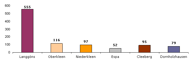
Numerous medium-sized companies create around 3000 jobs. There are 555 businesses in Lang-Göns. The Deutsche Post mail center 35 for the Gießen / Central Hesse area is located in the western industrial area .
literature
- Johann Bayer: On the history of the Lang-Göns community . Published by the community of Lang-Göns, Lang-Göns 1976.
- Otto Berndt, Friedrich Damrath, Hanno Müller: Jews in Lang-Göns. A documentation against forgetting. Fernwald printing workshop, Langgöns 2010.
- Otto Berndt: Lang-Göns. Insights into the past. Fernwald printing workshop, Langgöns 2013.
- Philipp Hofmann: Lang-Göns, a village book from the Hüttenberg . Publishing house of the community, Lang-Göns 1955.
- Philipp Hofmann: 700th anniversary of Lang-Göns . Publishing house Kreiling, Heuchelheim near Gießen 1952.
- State Office for the Preservation of Monuments Hesse (ed.), Karlheinz Lang (edit.): Cultural monuments in Hesse. District of Giessen II. Buseck, Fernwald, Grünberg, Langgöns, Linden, Pohlheim, Rabenau (= monument topography Federal Republic of Germany. ). Theiss, Stuttgart 2010, ISBN 978-3-8062-2178-7 , p. 270 ff.
- Reinhard K. Puhl: Lang-Göns. Pictures from days gone by. Geiger, Horb am Neckar 1988, ISBN 3-89264-269-9 .
- Otto Schulte: The field names of Lang-Göns (= Hessian field names book. 29). Langgöns 1955.
- Literature on Lang-Göns in the Hessian Bibliography
Web links
- Lang-Göns district. In: website. Langgöns community
- Lang-Göns, District of Giessen. Historical local dictionary for Hessen. In: Landesgeschichtliches Informationssystem Hessen (LAGIS).
Individual evidence
- ↑ a b c d e f g h i Langgöns, District of Giessen. Historical local dictionary for Hessen. (As of April 17, 2018). In: Landesgeschichtliches Informationssystem Hessen (LAGIS).
- ↑ a b Population figures in the budget of the municipality of Langgöns 2020. (PDF; 9.9 MB) p. 43 , accessed in June 2020 .
- ↑ Langgön's 2014 budget. Accessed September 17, 2019 .
- ↑ Hessian State Statistical Office: Area survey in Hesse as of December 31, 2018. Actual usage. Retrieved September 17, 2019 . .
- ^ Manfred Niemeyer (ed.): German book of place names . De Gruyter, Berlin 2012, ISBN 978-3-11-025802-8 ( limited preview in the Google book search).
- ↑ Berndt: Lang-Göns. Insights into the past. 2013, p. 5.
- ↑ Berndt: Lang-Göns. Insights into the past. 2013, p. 15.
- ^ Hofmann: Lang-Göns, a village book from the Hüttenberg . 1955, p. 89.
- ↑ Homepage of the municipality of Langgöns: The district of Lang-Göns , accessed on January 24, 2016.
- ↑ For the old Langgöns field names, see the documents on field names in Lang-Göns. Hessian field names. In: Landesgeschichtliches Informationssystem Hessen (LAGIS)., Accessed on June 19, 2016.
- ^ Hofmann: Lang-Göns, a village book from the Hüttenberg . 1955, pp. 42-44.
- ↑ Friedrich Kilian Abicht: The district of Wetzlar, presented historically, statistically and topographically. Vol. 3. Wetzlar 1836, p. 36 ( limited preview in the Google book search)
- ^ Gerhard Kleinfeldt, Hans Weirich: The medieval church organization in the Upper Hesse-Nassau area (= writings of the Institute for historical regional studies of Hesse and Nassau. 16). NG Elwert, Marburg 1937, ND 1984, p. 199.
- ^ Village chronicle committee (ed.): 850 years of Kirch-Göns. A village chronicle. Butzbach-Kirch-Göns 2000, p. 11, 50.
- ↑ a b Peter Weyrauch : Langgöns. In: The churches of the old district of Gießen. Mittelhessische Druck- und Verlagsgesellschaft, Gießen 1979, p. 104.
- ^ Bayer: On the history of the Lang-Göns community . 1976, p. 64.
- ↑ Berndt: Lang-Göns. Insights into the past. 2013, pp. 53–54.
- ^ L. Ewald: Contributions to regional studies . In: Grand Ducal Central Office for State Statistics (ed.): Contributions to the statistics of the Grand Duchy of Hesse . Jonghaus, Darmstadt 1862, p. 54.
- ^ Ordinance on the division of the country into districts and district courts of July 14, 1821 . In: Hessisches Regierungsblatt dated July 20, 1821, p. 407.
- ^ Ordinance on the division of the country into districts and district courts of July 14, 1821 . In: Hessian Government Gazette of July 20, 1821, p. 408.
- ^ Bayer: On the history of the Lang-Göns community . 1976, p. 74.
- ^ Wilhelm Diehl : Construction book for the Protestant parishes of the Landgraviate of Hessen-Darmstadt. (Hassia sacra; 5). Self-published, Darmstadt 1931, p. 243.
- ^ Hofmann: Lang-Göns, a village book from the Hüttenberg . 1955, p. 190.
- ↑ Berndt: Lang-Göns. Insights into the past. 2013, p. 67.
- ^ Hofmann: Lang-Göns, a village book from the Hüttenberg . 1955, pp. 115-116.
- ↑ Berndt: Lang-Göns. Insights into the past. 2013, p. 27.
- ^ Hofmann: Lang-Göns, a village book from the Hüttenberg . 1955, p. 145.
- ^ Hofmann: Lang-Göns, a village book from the Hüttenberg . 1955, p. 162.
- ^ A b Georg Wilhelm Justin Wagner : Statistical-topographical-historical description of the Grand Duchy of Hesse: Province of Upper Hesse . tape 3 . Carl Wilhelm Leske, Darmstadt August 1830, OCLC 312528126 , p. 153 f . ( Online at google books ).
- ↑ Berndt: Lang-Göns. Insights into the past. 2013, p. 46.
- ^ Hofmann: Lang-Göns, a village book from the Hüttenberg . 1955, p. 44.
- ^ Hofmann: Lang-Göns, a village book from the Hüttenberg . 1955, p. 196.
- ^ Bayer: On the history of the Lang-Göns community . 1976, p. 63.
- ^ Hofmann: Lang-Göns, a village book from the Hüttenberg . 1955, pp. 122-124.
- ^ Hofmann: Lang-Göns, a village book from the Hüttenberg . 1955, p. 153.
- ↑ Berndt: Lang-Göns. Insights into the past. 2013, p. 55.
- ↑ Berndt: Lang-Göns. Insights into the past. 2013, p. 39.
- ↑ Berndt: Lang-Göns. Insights into the past. 2013, p. 168.
- ↑ Otto Berndt, Friedrich Damrath, Hanno Müller: Jews in Lang-Göns. A documentation against forgetting. Fernwald printing workshop, Langgöns 2010.
- ^ Hofmann: Lang-Göns, a village book from the Hüttenberg . 1955, p. 231.
- ^ Hofmann: Lang-Göns, a village book from the Hüttenberg . 1955, p. 232.
- ^ Hofmann: Lang-Göns, a village book from the Hüttenberg . 1955, pp. 234-239.
- ^ Hofmann: Lang-Göns, a village book from the Hüttenberg . 1955, p. 124.
- ↑ Law on the restructuring of the Dill district, the districts of Gießen and Wetzlar and the city of Gießen (GVBl. II 330–28) of May 13, 1974 . In: The Hessian Minister of the Interior (ed.): Law and Ordinance Gazette for the State of Hesse . 1974 No. 17 , p. 237 ff ., § 12 ( online at the information system of the Hessian state parliament [PDF; 1,2 MB ]).
- ↑ Local councils of the Langgöns community. In: website. Langgöns municipality, accessed February 2019 .
- ↑ Arthur B. Schmidt: The historical foundations of civil law in the Grand Duchy of Hesse . Curt von Münchow, Giessen 1893, p. 100, note 6 and p. 9, 11.
- ^ Michael Rademacher: German administrative history from the unification of the empire in 1871 to the reunification in 1990. State of Hesse. (Online material for the dissertation, Osnabrück 2006).
- ^ Grand Ducal Central Office for State Statistics (ed.): Contributions to the statistics of the Grand Duchy of Hesse . tape 13 . G. Jonghause's Hofbuchhandlung, Darmstadt 1872, DNB 013163434 , OCLC 162730471 , p. 12 ff . ( Online at google books ).
- ^ The affiliation of the Office Hüttenberg based on maps from the Historical Atlas of Hesse : Hessen-Marburg 1567-1604 . , Hessen-Kassel and Hessen-Darmstadt 1604–1638 . and Hessen-Darmstadt 1567–1866 .
- ^ Grand Ducal Central Office for State Statistics (ed.): Contributions to the statistics of the Grand Duchy of Hesse . tape 13 . G. Jonghause's Hofbuchhandlung, Darmstadt 1872, DNB 013163434 , OCLC 162730471 , p. 16 , § 28 ( online at google books ).
- ↑ Wilhelm von der Nahmer: Handbuch des Rheinischen Particular-Rechts: Development of the territorial and constitutional relations of the German states on both banks of the Rhine: from the first beginning of the French Revolution up to the most recent times . tape 3 . Sauerländer, Frankfurt am Main 1832, OCLC 165696316 , p. 8 ( online at google books ).
- ↑ a b Hessen-Darmstadt state and address calendar 1806 . In the publishing house of the Invaliden-Anstalt, Darmstadt 1806, p. 262 ff . ( Online in the HathiTrust digital library ).
- ↑ Latest countries and ethnology. A geographical reader for all stands. Kur-Hessen, Hessen-Darmstadt and the free cities. tape 22 . Weimar 1821, p. 419 ( online at Google Books ).
- ^ Georg W. Wagner: Statistical-topographical-historical description of the Grand Duchy of Hesse: Province of Upper Hesse . tape 3 . Carl Wilhelm Leske, Darmstadt 1830, p. 91 ff . ( online at Google Books ).
- ^ Hofmann: Lang-Göns, a village book from the Hüttenberg . 1955, p. 164.
- ↑ Hessen-Darmstadt state and address calendar 1791 . In the publishing house of the Invaliden-Anstalt, Darmstadt 1791, p. 200 ff . ( Online in the HathiTrust digital library ).
- ↑ Hessen-Darmstadt state and address calendar 1800 . In the publishing house of the Invaliden-Anstalt, Darmstadt 1800, p. 217 ff . ( Online in the HathiTrust digital library ).
- ↑ Housing spaces 1867 . In: Grossherzogliche Centralstelle für die Landesstatistik (Ed.): Contributions to the statistics of the Grand Duchy of Hesse . tape 13 . G. Jonghause's Hofbuchhandlung, Darmstadt 1877, DNB 013163434 , OCLC 162730484 , p. 116 ( online at google books ).
- ↑ Residential places 1875 . In: Grossherzogliche Centralstelle für die Landesstatistik (Ed.): Contributions to the statistics of the Grand Duchy of Hesse . tape 13 . G. Jonghause's Hofbuchhandlung, Darmstadt 1877, DNB 013163434 , OCLC 162730484 , p. 11 ( online at google books ).
- ↑ Population figures in the budget of the municipality of Langgöns 2009. (PDF; 4.7 MB) p. 23 , accessed in February 2019 .
- ↑ Selected data on population and households on May 9, 2011 in the Hessian municipalities and parts of the municipality. (PDF; 1 MB) In: 2011 Census . Hessian State Statistical Office
- ↑ Approval of a coat of arms of the municipality of Lang-Göns in the district of Gießen, administrative district of Darmstadt from December 15, 1954 . In: The Hessian Minister of the Interior (ed.): State Gazette for the State of Hesse. 1955 no. 1 , p. 2 , point 4 ( online at the information system of the Hessian state parliament [PDF; 3.9 MB ]).
- ↑ Berndt: Lang-Göns. Insights into the past. 2013, p. 16.
- ↑ Approval of a flag for the municipality of Lang-Göns, district of Gießen, administrative district of Darmstadt from November 28, 1967 . In: The Hessian Minister of the Interior (ed.): State Gazette for the State of Hesse. 1967 No. 50 , p. 1552 , point ( online at the information system of the Hessian state parliament [PDF; 4.0 MB ]).
- ↑ Wetzlarer Neue Zeitung from September 25, 2014: 239-year-old signature discovered , accessed on January 28, 2016.
- ^ State Office for the Preservation of Monuments in Hesse: Cultural monuments in Hesse. District of Giessen II. 2010, pp. 285–286.
- ^ State Office for the Preservation of Monuments in Hesse: Cultural monuments in Hesse. District of Giessen II. 2010, p. 280.
- ^ State Office for the Preservation of Monuments in Hesse: Cultural monuments in Hesse. District of Giessen II. 2010, pp. 284–285.
- ↑ langgoens-web.de: Number of businesses according to districts

Cleeberg | Dornholzhausen | Espa | Lang-Göns | Niederkleen | Upper clover