Gonsbach
| Gonsbach | ||
|
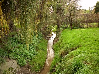
Run of the Gonsbach on the edge of the Mainz district of Gonsenheim |
||
| Data | ||
| Water code | DE : 25112 | |
| location | Germany | |
| River system | Rhine | |
| Drain over | Rhine → North Sea | |
| origin | in Mainz-Finthen through the confluence of the Aubach and Königsbornbach rivers 49 ° 59 ′ 38 ″ N , 8 ° 10 ′ 56 ″ E |
|
| Source height | approx. 148 m above sea level NHN | |
| muzzle | In Mainz from the left in the Rhine coordinates: 50 ° 1 '15 " N , 8 ° 15' 12" E 50 ° 1 '15 " N , 8 ° 15' 12" E |
|
| Mouth height | approx. 93 m above sea level NHN | |
| Height difference | approx. 55 m | |
| Bottom slope | approx. 5.6 ‰ | |
| length | 9.8 km (including Aubach 1.32 km) | |
| Catchment area | 26.056 km² | |
The Gonsbach is part of a stream system of the city of Mainz in Rhineland-Palatinate and a left tributary of the Rhine .
course
The Gonsbach and its tributaries flow through the districts of Layenhof , Finthen , Gonsenheim and Mombach . It is created in Mainz-Finthen through the confluence of the Aubach and Königsbornbach rivers . The Aubach provides the greater amount of water, but its water quality with normal discharge can be described as moderately to heavily polluted. In Gonsenheim, small amounts of water from the so-called Hemelfloss and more from Leichborn and Waschbach enter the main course, which increase the water quality. 14 former subordinate streams could be reconstructed, from which at least two important tributaries are demonstrably derived in the sewer system. The so-called Kirchborn in Finthen was first partially piped in 1892 when the station was built for the steam train line. In the 1960s the street Am Kirchborn was laid out, the stream disappeared completely from the surface.
Hydrology
The Gonsbach is, according to its origin from the predominantly calcareous bedrock of Rheinhessen , a carbonate brook. It belongs to a rare and sensitive type of water body in the arid regions with low but relatively uniform water flow ( MNQ ≈ 20 l / s in 1996, ≈ 8 l / s in 2005) and short discharge times of the springs , some of which are near the surface and therefore heavily precipitation-dependent floating groundwater horizons are fed. Due to the climatic changes, i. H. reduced groundwater supply , overbuilding of catchment areas , effluence and direct damage (Waschbach spring ), the flow rate has decreased in recent years. Important tributaries such as the Königsborn are z. Sometimes dry for several months from July.
Chemism
The pH of the Gonsbach varies between 7.8 and 8.7. The high, geogenically determined sulfate content of the water (≈ 150 mg / l) is striking . Chloride peaks only occur during discharges from the sewer system. The water shows a high nitrate load of 40 mg / l, which comes mainly from the Aubach catchment area; The nitrite and ammonium levels are correspondingly high . Exposure to pesticides is suspected in view of the absence of certain groups of lower animals.
Renaturation
In the spring of 2013, work began to renaturate the Gonsbach in the Mainz-Gonsenheim district, initially over a length of 1.2 km between Mainzer Strasse and the Lungenberg retention basin. With the renaturation measures, the city of Mainz responded to the European Water Framework Directive , which obliges the EU member states to achieve a good status of their waters by 2015.
Culture
- The name Gonsbach became known nationwide in the 1960s and 1970s through the Gonsbachlerchen . The Gonsbacher Fastnachtergruppe, founded in 1946 around Josef “Joe” Ludwig and Herbert Bonewitz , became an integral part of the communal television meeting Mainz remains Mainz as it sings and laughs .
- The political songwriter Franz Josef Degenhardt dedicated the title Im Gonsbachtal to the Gonsbach on his album Suede Coat Man , published in 1977 .
- In the course of the Gonsbach renaturation at the end of 2013, remnants of Roman structures near the surface were found in a wastewater basin on Angelrechweg , namely several buildings and a circular arena . The size and structural quality of the Roman remains suggest military use. A larger circular structure with a diameter of 40 m resembles an oval track or a lunging area in today's equestrian sport . There is a possibility that it was a facility for Roman cavalrymen and their training - also in view of the stream location and meadows that are favorable for animal husbandry . In the meantime, the archaeologists in charge of the Mainz Archeology Department have identified the facility as a stud from late antiquity, possibly operated by the military stationed in Mogontiacum .
Web links
- Photo documentation from 2014 - during the renaturation (between Mainzer Straße and the Lungenberg retention basin)
- Photo documentation from 2016 - two years after the renaturation (between Mainzer Straße and the Lungenberg retention basin)
Individual evidence
- ↑ a b Topographic map 1: 25,000
- ↑ a b Rhineland Water Management Administration
- ↑ Renaturation of the Gonsbach: Now things really start! In: mainz.de. Press service of the state capital Mainz, May 14, 2013, accessed on August 13, 2013 .
- ↑ Allgemeine Zeitung (Mainz) , January 17, 2014. Retrieved February 10, 2014.
- ↑ Roman traces in Gonsenheim. In: regionalgeschichte.net. Retrieved August 30, 2016 .
- ↑ New home for frogs and insects: renaturation of the Gonsbach valley over a length of 1200 meters. In: Allgemeine Zeitung (Mainz) , September 10, 2015, accessed on August 31, 2016.


