Konyaaltı
| Konyaaltı | ||||
|
||||
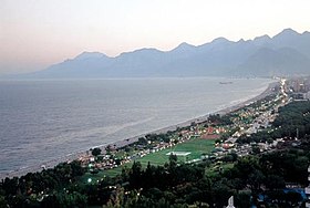
 Konyaaltı Beach |
||||
| Basic data | ||||
|---|---|---|---|---|
| Province (il) : | Antalya | |||
| Coordinates : | 36 ° 50 ′ N , 30 ° 29 ′ E | |||
| Telephone code : | (+90) 242 | |||
| Postal code : | 07 xxx | |||
| License plate : | 07 | |||
| Structure and administration (as of 2019) | ||||
| Structure : | 39 Mahalle | |||
| Mayor : | Semih Esen ( CHP ) | |||
| Postal address : | Kuşkavağı Mahallesi Belediye Caddesi No: 77 07070 Konyaaltı / Antalya |
|||
| Website: | ||||
| Konyaaltı County | ||||
| Residents : | 182,112 (2018) | |||
| Surface: | 546 km² | |||
| Population density : | 334 inhabitants per km² | |||
| Kaymakam : | Kamil Köten | |||
| Website (Kaymakam): | ||||
Konyaaltı is a district ( İlçe ) in the Turkish province of Antalya and, together with the district town of Finike, is also part of the Büyükşehir belediyesi Antalya (metropolitan municipality / metropolitan province ) created in 1993 . The district is located in the southwest of the provincial capital and borders on Korkuteli and Kumluca in the west, Kemer in the south, Muratpaşa and Kepez in the east and Döşemealtı in the north .
Since a regional reform in 2014, the district has been identical in terms of area and population to the district town; all former villages and communities in the district have become Mahalla (districts) of the city.
Konyaaltı Beach in the west of Antalya is a popular bathing beach. The Minicity Amusement Park is located in Konyaaltı.
Individual evidence
- ↑ Türkiye Nüfusu , accessed on September 4, 2019


