Krušná hora
| Krušná hora | ||
|---|---|---|
|
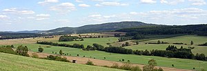
View from the Špička to Nový Jáchymov and the Krušná hora |
||
| height | 609 m nm | |
| location | west of Hudlice , Czech Republic | |
| Mountains | Křivoklátská vrchovina | |
| Coordinates | 49 ° 57 '47 " N , 13 ° 55' 47" E | |
|
|
||
The Krušná hora (German Kruschnahora , also Kruschna ) is a mountain in the Czech Republic . It is located ten kilometers west of the city center of Beroun and is part of the Křivoklátská vrchovina.
Location and surroundings
The wooded ridge of the Krušná hora is surrounded by the Habrový brook in the west and north and the Dibeřský brook in the south-east. It is located in the Křivoklátsko Protected Landscape Area . To the east rises the Děd (492 m) and in the southwest of the Velíz (595 m).
Surrounding villages are Stará Ohrada and Nový Jáchymov in the north, Krušná Hora, Doužebnice and Otročiněves in the Northeast, Lísek, Hudlice and Trubská the east, Trubín , Svatská Hájovna, Svatá and Král in the southeast, Varta, Hředle and Březová in the south, Kublov in southwest , Broumy and Habrový Potok in the west and Karlova Ves and Karlov in the northwest.
Mining
The hematite iron ore deposit on the Krušná hora has been intensively mined since the 18th century under Karl Egon I. zu Fürstenberg and is one of the most important in Bohemia. From the Habrový potok valley in 1772, a new deep hereditary tunnel, the Josephi tunnel, was excavated to clear the pits on the Krušná hora and the Hudlický kopec. The ores were u. a. Processed in the iron and steel works of Neuhütten , Althütten , Karlshütten , Františkov , Strašice and Holoubkov . In 1810 the Neu-Joachimsthal miners' settlement was laid out with a shift house for the iron ore mines. In 1817 an ironworks with the blast furnaces Karl and Amalie started operations in Neu-Joachimsthal.
In 1844 mining was carried out with a 45 fathom deep main shaft, two weather shafts and a 300 fathom long conveyor tunnel with an English hunted railway that led to the Neu-Joachimsthaler Hütte. The iron ore mining consisted of 20 large and 74 small pits, most of which belonged to the Püglitz rule . 167,482 quintals of ore were melted in the Princely-Fürstenberg ironworks, especially in Neu-Joachimsthal. The Imperial and Royal Shift Offices of the Aerial Montanherrschaft Zbiroh and Königshof had two large and 38 small sizes, in which around 100 miners annually delivered 105,905 tenth of ore for the Imperial and Royal Huts Franzenshütte and Karlshütten .
After the ironworks in Neu-Joachimsthal ceased in 1889, most of the ores were transported to the Karlshütten ironworks. In 1915, a 6,971 m long Lorenseilbahn to Karlshütten was put into operation. After the Second World War, the Důl Gabriela mine was the largest iron ore mine in Czechoslovakia. The Lorenseilbahn operation to the hut was stopped in the 1960s with the closure of the Důl Gabriela colliery on the southern slope of the mountain.
Individual evidence
- ↑ Johann Gottfried Sommer The Kingdom of Bohemia, Vol. 13 Rakonitzer Kreis, 1845, pp. 272-275

