Březová u Hořovic
| Březová | ||||
|---|---|---|---|---|
|
||||
| Basic data | ||||
| State : |
|
|||
| Region : | Středočeský kraj | |||
| District : | Beroun | |||
| Area : | 464.8639 ha | |||
| Geographic location : | 49 ° 55 ' N , 13 ° 53' E | |||
| Height: | 351 m nm | |||
| Residents : | 339 (Jan 1, 2019) | |||
| Postal code : | 267 51 | |||
| License plate : | S. | |||
| traffic | ||||
| Street: | Žebrák - Broumy | |||
| structure | ||||
| Status: | local community | |||
| Districts: | 1 | |||
| administration | ||||
| Mayor : | Martina Nedvědová (as of 2013) | |||
| Address: | Březová 23 267 51 Zdice |
|||
| Municipality number: | 531090 | |||
| Website : | www.brezova-be.cz | |||
| Location of Březová in the Beroun district | ||||

|
||||

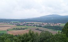
Březová (German Bschesowa ) is a municipality in the Czech Republic . It is located seven kilometers north of Hořovice and belongs to the Okres Beroun .
geography
Březová is located in the south of the Pürglitzer Uplands on a hill above the confluence of the Pekelský and Pařezový potok to the Stroupinský Potok. To the south are the castles Žebrák and Točník .
Neighboring towns are Kublov in the north, Hředle in the east, Chlustina in the southeast, Točník in the south and Bzová in the southwest.
history
Březová was first mentioned in a document in 1399. The village originally stood northwest of its current location in the Pürglitzer forest in the Petrovka clearing. The place, known for its pottery, belonged to the Točník estate and was also mentioned when Jan the Elder Lobkowicz bought it in 1557. In 1593 his son Georg III lost. vom Lobkowicz all goods because of participation in the conspiracy against Emperor Rudolf II. His confiscated property fell to the Royal Chamber.
During the Thirty Years War , Březová was destroyed and not rebuilt on the old square. In the second half of the 17th century, a new settlement was founded at the current location, which never regained its old importance. After patrimonial was replaced in 1848, Březová became part of the Bzová municipality and became independent in 1874. In 1877 the first village school started teaching.
During the Second World War, the third illegal plenum of the Central Committee of the Communist Party of Czechoslovakia took place on July 9, 1943 in Chata Votruba in Údolí ticha .
Local division
No districts are shown for the municipality of Březová.
Attractions
- small chapel with bell tower
- Údolí ticha between Kublov and Točník
- Folk style chalets

