Vysoký Újezd u Berouna
| Vysoký Újezd | ||||
|---|---|---|---|---|
|
||||
| Basic data | ||||
| State : |
|
|||
| Region : | Středočeský kraj | |||
| District : | Beroun | |||
| Area : | 1155.3776 ha | |||
| Geographic location : | 50 ° 0 ′ N , 14 ° 12 ′ E | |||
| Height: | 432 m nm | |||
| Residents : | 869 (Jan. 1, 2019) | |||
| Postal code : | 267 16 - 267 18 | |||
| License plate : | S. | |||
| traffic | ||||
| Street: | Nučice - Bubovice | |||
| structure | ||||
| Status: | local community | |||
| Districts: | 3 | |||
| administration | ||||
| Mayor : | Marie Severinová (as of 2015) | |||
| Address: | Vysoký Újezd 113 267 16 Vysoký Újezd u Berouna |
|||
| Municipality number: | 531961 | |||
| Website : | www.vysoky-ujezd-urad.cz | |||
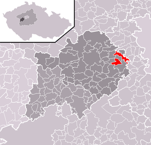
| Location of Vysoký Újezd in the Beroun district | ||||

|
||||
Vysoký Újezd (German Hochaugezd , also Hochaujest ) is a municipality in the Czech Republic . It is located 18 kilometers southwest of the city center of Prague and belongs to the Okres Beroun .
geography
Vysoký Újezd is located on the edge of the Bohemian Karst on a hill on the Třebotovská plošina ( Trebotau plateau ). In the north rises the Hačka (425 m nm), south the Rohlová (408 m nm) and in the west the Čížovec (424 m nm) and the Kolo (408 m nm). The brook Krahulovský potok rises north of the village, on the southern outskirts of the village Karlický potok. The Kladno-Nučice Railway runs east of Vysoký Újezd . The Albatross Golf Resort extends west of the village.
Neighboring towns are V hlubokém and Mezouň in the north, Tachlovice and Prostřední Mlýn in the Northeast, Chýnice and Choteč the east, Kuchař and Roblín the southeast, Trněný Újezd and Mořina in the south, Kozolupy, Lužce and Bubovice in the southwest, Cernidla, Janská, Loděnice and Chrustenice in the west and V Hačkách in the northwest.
history
The village of Vysoký Újezd was probably created in the course of the Slavic expansion of the country by riding around and was given a prefix according to its geographical location to distinguish it from places of the same name. In the course of time, the village was referred to as Wysoký Aujezd , Wysoký Aujezdec , Oujezd Wysoký , Oujezdec Wysoký , Hochaugezd or Hochaujest and with the nickname Bačalákov .
The Kunrádův manor, which is probably identical to Vysoký Újezd, was first mentioned in writing in 1310. Its owner was probably Konrad, the son of Queen Guta von Habsburg 's chamberlain of the same name , who at that time was a witness when measuring the boundaries of the forests of the Königsaal monastery kicked. On November 6, 1324 the same drew in another boundary definition of the Königsaal forests in Brdy as Conrádus guondam Conradi regine cameraii de Vgesd filius . In 1353 the village of Vysoký Újezd was mentioned for the first time. In the second half of the 14th century, the estate belonged to the St. George Monastery at Prague Castle. The subsequent owner was the Strahov Monastery between 1409 and 1581, with a short break during the Hussite Wars . This sold the estate in 1581 to Jakob Berbek von Kunwald. Two years later, Berbek transferred the property to his wife Katharina, née Kašpárková von Pallatin. On August 2, 1598, the imperial court postmaster Heinrich Georg Pichl von Pichlberg on Chrustenice acquired the Wysoký Aujezd estate for 7,000 shock Meissniche groschen, and the festival was also mentioned for the first time. Georg's son Rudolf Pichl von Pichlberg sold the estate to Johanna Katharina von Skuhrow after his father's death in 1616, who sold it to Johann Mencelius von Kolsdorf in 1622. The following owners of Vysoký Újezd were Daniel Nečanský von Minice, from 1682 Marie Margarethe Slavatová von Trautson and from 1693 Franz Joseph Graf Schlik zu Bassano and Weißkirchen , who acquired the estate for 15,000 Rhenish guilders. The latter had the fortress converted into a castle with a chapel after 1700. Count Schlik sold the property to Mathias Franz Jonak von Freienwald until 1763. His son Franz sold the allodial property Hoch-Augezd in 1820 to Johann Kratschmer, who two years later sold it to Franz Dostal. In 1825 the owner of the allodial estate St. Johann under the rock Walburga von Lackner, née Pachmann, acquired the Hoch-Augezd estate including the attached Strkow farm. It united the allodial estates St. Johann unter dem Felsen and Hoch-Augezd as well as the fiefdom Strkow or Rubrin into one manorial estate. She later married Maximilian Berger, who inherited the property after her death in 1846.
In 1847, the Hoch-Augezd estate in the Berauner district comprised a usable area of 532 yokes 195 square fathoms , of which over 103 yokes were manorial forests. Agriculture was the only source of income. A few smaller limestone quarries and lime kilns were operated for local needs. Only the village Hoch-Augezd or Augezd wysoký belonged to the estate , in whose 47 houses with 479 people lived. These included six Jewish houses with 73 inhabitants, which were inhabited by twelve Jewish families. In the village there was an official palace with a palace chapel and palace garden, a farm with a sheep farm, a contribution grain bulk floor, an inn and a branch school in a rented room. The parish was Tachlowitz , the official place was St. Johann unter dem Felsen.
After the abolition of patrimonial made Vysoký Oujezd / high-Augezd 1850 a municipality in the judicial district of Beroun. In 1868 the municipality was assigned to the Hořowitz district . In 1870 Heliodor Franz Heid bought the estate. On April 20, 1875 Jakub Krása bought the estate for 170,050 guilders; thereafter, on February 6, 1883, Johann Franz Kreisl, who had been the landowner in Hoch-Augezd for 45 years, acquired the property on the basis of a right of first refusal. In 1909 he was raised to the nobility as a nobleman von Kreisl. The current place name Vysoký Újezd has been used since the beginning of the 20th century . In the course of the land reform, 56 hectares of land were sold to farmers, the estate was kept 263 hectares. After their father's death in 1928, Johannes and Victor Kreisl inherited the estate and sold it to Václav and Irma Stome the following year. In 1935 the Stome couple divided the estate into two ideal halves. In 1935 the Stome couple sold the estate to Jaroslav and Wilhelmine Heinitz. Since 1936 Vysoký Újezd has belonged to the Okres Beroun. In 1938 Marie Heinitz inherited the estate and Šnajdrová married in 1939. In 1948 the Šnajdr family was expropriated and the castle was nationalized; later the castle became the seat of a state estate. In 1976 the castle of the Jednotné zemědělské družstvo (JZD) Československo-sovětského přátelství Mořina was transferred, who used it as a canteen, office and residential building. The municipal administration office was also housed in it. In 1980 Lužce was incorporated , and in 1986 Kuchař and Kozolupy were added as districts. In 1990 the castle was returned to the previous owner. On November 24, 1990, the district of Lužce broke away from Vysoký Újezd and formed its own municipality. Since then, the municipality has been divided into a northeastern (Vysoký Újezd and Kuchař) and a southwestern part (Kozolupy), between which the municipality of Lužce is located.
Community structure
The municipality Vysoký Újezd consists of the districts and cadastral districts Kozolupy ( Kosolup ), Kuchař ( Kucharsch , 1939-1945 Koch ) and Vysoký Újezd ( Hochaujest ).
Attractions
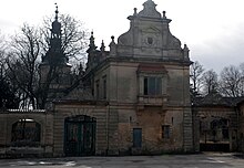
- Vysoký Újezd Castle with the Castle Chapel of St. Johannes, the single-storey building was built at the beginning of the 18th century for Franz Joseph Graf Schlik instead of an old fortress. In 1897 it was rebuilt in the neo-renaissance style. Since 1990 the dilapidated castle has been privately owned by the Šnajdr family again and is not open to the public.
- Chapel in the village square ( Tyršova náves )
- Niche chapel of St. Anthony of Padua on the U tří habrů square on the eastern slope of the Kolo, it was built in 1892 at a spring and renovated in 2008
- House number 54, former synagogue
Web links
Individual evidence
- ↑ http://www.uir.cz/obec/531961/Vysoky-Ujezd
- ↑ Český statistický úřad - The population of the Czech municipalities as of January 1, 2019 (PDF; 7.4 MiB)
- ^ Johann Gottfried Sommer The Kingdom of Bohemia, Vol. 16 Berauner Kreis, 1849, pp. 15-16
- ↑ http://www.uir.cz/casti-obce-obec/531961/Obec-Vysoky-Ujezd
- ↑ http://www.uir.cz/katastralni-uzemi-obec/531961/Obec-Vysoky-Ujezd


