Krudum
| Krudum | ||
|---|---|---|
| height | 838 m nm | |
| location | Czech Republic | |
| Mountains | Kaiserwald | |
| Coordinates | 50 ° 8 '24 " N , 12 ° 43' 29" E | |
|
|
||
| rock | granite | |
| particularities | Transmission and observation tower | |
|
Krudum transmission tower
rozhledna krudum
|
|
|---|---|
| Basic data | |
| Place: | Krudum mountain, Horní Slavkov municipality |
| Okres: | Falkenau on the Eger |
| Region: | Karlovy Vary |
| Country: | Czech Republic |
| Altitude : | 836 m nm |
| Coordinates : | 50 ° 8 '15.1 " N , 12 ° 43' 45.6" E |
| Use: | Broadcasting station , observation tower |
| Accessibility: | Transmission tower open to the public |
| Tower data | |
| Construction time : | 2008 |
| Building material : | steel |
| Operating time: | since 2008 |
| Total height : | 50 m |
| Viewing platform: | 30 m |
| Data on the transmission system | |
| Waveband : | FM transmitter |
| Radio : | VHF broadcasting |
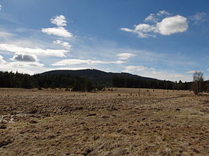
The Krudum , also Chrudim (838 m above sea level) is a mountain in the Imperial Forest (Slavkovský les) in the Czech Republic .
geography
The mountain consists of a north summit (838 m), west summit (831 m) and east summit (837 m) as well as the northwestern foothill Zelený močál (797 m) and is located six kilometers west of Horní Slavkov . To the north rises the Spálený vrch (744 m), in the northeast of the Kozí vrch (620 m), southeast of the Svárov (710 m), Malý Špičák (824 m) and Špičák (828 m), in the south of the Komáří vrch (791 m) ) and Rozhledy (859 m), southwest of the Stolec (784 m), in the west of the Lobezský vrch (805 m) and Zlatý vrch (777 m) and northwest of the Pařez (701 m). On the pass at the northern foot of the mountain lies the desolate Church of St. Nicholas under the Krudum ( Kostel sv. Mikuláše pod Krudumem ). The Franzosenstein, a trigonometric point, is located on the western summit . The east summit carries a 50 m high telecommunication tower and the rubble of the Dr.-Kempf-Warte. The mountain is covered with spruce forest.
The surrounding villages are Hrušková in the north, Nadlesí and Třídomí in the northeast, Horní Slavkov in the east, Puškařov and Krásno in the southeast, the deserted areas of Čistá and Podstrání in the south, the deserted areas of Milíře in the southwest, Lobzy in the west and Novina and Vítkov in the northwest.
history
In the Middle Ages, the trade route led over the Krudumpass from Eger via Königsberg , Schlaggenwald , Beschau and Luditz to Prague . In the 12th and 13th centuries there was intensive silver mining at the Krudum. The church of St. Nicholas on the street was first mentioned in 1253 and existed until the beginning of the 16th century. Gold soaps were operated below the mountain. In addition, were to amethyst mined.
In the course of land surveying under Emperor Franz II in 1808, a trigonometric point was set on the western summit. The stone bears the inscription Reg Imp Fr pmo 1808 and later became popularly known as the Franzosenstein.
In 1931 the Eghalanda Gmoi had a 10 m high stone observation tower with battlements built on the east summit, which was inaugurated on September 11, 1932 in honor of the Viennese doctor Andreas Kempf (1865-1929), who grew up in Dreihäuser ( Třídomí ) Name Dr.-Kempf-Warte / Kempfova věž received. To finance the construction of the tower, the owner of the Elbogen Porcelain Manufactory, Anton Thun, published a collection of Egerland prose Kempfs about the Krudum and the area in 1931, the proceeds of which were used to cover most of the construction costs. After the Second World War, the Kempfova věž fell into disrepair and collapsed in the 1970s. In 2001 an association was founded to rebuild the tower, but it was never tackled.
In the 1980s and 1990s, remains of the wall were uncovered during wind breaks at the northern foot of the mountain. The archaeological excavations carried out between 2002 and 2006 identified them as the remains of the lost St. Nicholas Church.
In 2008, next to the rubble of Kempfova věž, at an altitude of 836 m nm, a 50 m high transmission tower was built, which, in addition to radio communication, is also used for tourism and has a viewing platform at a height of 30 m.


