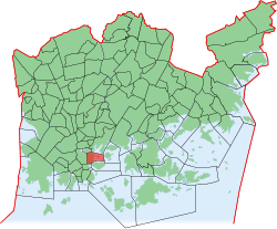
Kruununhaka
|
Kruununhaka (Kronohagen) District No. 1 of Helsinki |
|
|---|---|
| Coordinates | 60 ° 10 '20 " N , 24 ° 57' 23" E |
| surface | 0.57 km² |
| Residents | 6684 (Jan. 1, 2006) |
| Population density | 11,726 inhabitants / km² |
| Jobs | 7238 (Dec. 31, 2004) |
| Source: Helsinki City Statistics Office: Helsinki alueittain 2006 (PDF, 12 MB, Finnish) | |
Kruununhaka ( Swedish Kronohagen ) is a sub-area ( Finnish. Osa-alue ) and a district ( kaupunginosa ) in the center of the Finnish capital Helsinki with almost 6,700 inhabitants. Kruununhaka is located in the northeast of the peninsula on which downtown Helsinki is located. The name of the district literally means "crown pasture" and indicates that the area was previously used as state pasture land.
The Kruununhaka is bordered to the west by Unioninkatu Street and to the south by Kauppatori Market Square. Kruununhaka borders the sea to the north and west. Kruununhaka is connected to the neighboring Kallio district to the north by a bridge over the Siltavuorensalmi strait. The classical center of Helsinki with the Senate Square and the cathedral belongs to the area of Kruununhaka. In essence, however, the district is associated with the neighboring districts around Liisankatu Street to the north. These are mainly built on with Art Nouveau houses from the early 20th century. One of the few remnants of the original wooden houses is the Ruiskumestarin talo town house, built in 1818 and now a museum. To the east of Kruununhaka lies the island of Tervasaari (Tjärholmen), which is home to a park and is connected to the mainland by a dam.
Web links

