Etu-Töölö
|
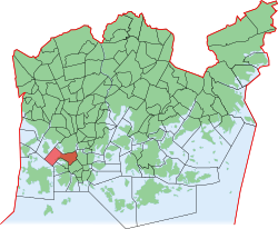
Etu-Töölö (Främre Tölö) District No. 13 of Helsinki |
|
|---|---|
| Coordinates | 60 ° 10 '23 " N , 24 ° 55' 33" E |
| surface | 1.18 km² |
| Residents | 12,950 (Jan. 1, 2005) |
| Population density | 10,975 inhabitants / km² |
| Source: Helsinki City Statistics Office: Helsinki alueittain 2006 (PDF, 12 MB, Finnish) | |
Etu-Töölö ( front Töölö ; Swedish Främre Tölö ) is a district ( kaupunginosa ) of the Finnish capital Helsinki .
geography
The Etu-Töölö district borders in the north along the Hesperian esplanadi park on Taka-Töölö , in the east on the Mannerheimintie on Kluuvi , in the southeast, marked by the Rautatiekatu , on Kamppi and in the south with the beginning of the Hietaniemi cemetery on Länsisatama . To the west of the district is the Hietaniemenlahti bay , to the northeast is the Töölönlahti bay . Etu-Töölö forms together with the other areas Kamppi, Lapinlahti , Ruoholahti and Jätkäsaari the municipality ( peruspiiri ) Kampinmalmi .
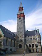
Etu-Töölö are in the field of Runeberginkatu and Arkadiankatu several organizations from academia Helsinki, including the Sibelius Academy , the Hanken School of Economics and the Helsinki School of Aalto University . In the southeast on Mannerheimintie is the Eduskuntatalo, the seat of the Finnish Parliament , further north, opposite the Finlandia Hall, the National Museum . To the west of the district is the Hietaranta beach .
traffic
The district is located west of Helsinki Central Station . In addition, several lines of the Helsinki tram open up the district.
The two main roads are the Mannerheimintie in the east and the Mechelininkatu in the west, which run in a north-south direction.
From the small bay Taivallahti at the western end of the Hesperian esplanadi there is a ferry to the small island of Mustasaari .
Personalities
- Alvar Aalto (1898–1976), architect and designer
- Martti Ahtisaari (* 1937), politician and diplomat
- Georg Malmstén (1902–1981), musician
- Mika Waltari (1908–1979), writer


