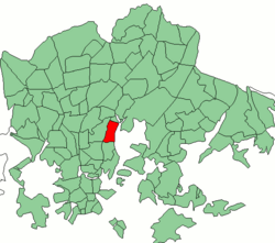
Toukola
|
Toukola (Majstad) district number 23 of Helsinki |
|
|---|---|
| Coordinates | 60 ° 12 '24 " N , 24 ° 58' 23" E |
| surface | 0.94 km² |
| Residents | 4601 (Jan 1, 2008) |
| Population density | 4895 inhabitants / km² |
| structure | |
| Sub-areas |
Toukola (23.1) |
| Source: Helsinki City Statistics Office: Helsinki alueittain 2006 (PDF, 12 MB, Finnish) | |
Toukola ( Swedish Majstad ) is a district ( kaupunginosa ) of the Finnish capital Helsinki .

The district consists of the two sub-areas Toukola and Arabianranta, which are separated by the Hämeentie . The two sub-areas are part of the statistical urban district ( peruspiiri ) Vanhakaupunki . The district of Toukola borders in the north on Vanhakaupunki, in the south on Hermanni and in one point on Vallila . To the west, the Kustaa Vaasan tie forms the border to Kumpula .
In the original Toukola, old wooden villas still predominate today. The later sub-area Arabianranta was developed in the 19th century when Rörstrand established the ceramic factory Arabia here. After the factory had moved, the area was subject to steady decline before construction of new modern houses in close proximity to the sea began around 2000.
traffic
After Arabianranta, trams 6 and 8 go via the city center to Hietalahti or Jätkäsaari . There are also various bus routes.
North of the city of part starts at the end Kustaa Vaasan tie the Valtatie 4 direction Vantaa .


