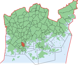
Kluuvi
|
Kluuvi (Gloet) District No. 2 of Helsinki |
|
|---|---|
| Coordinates | 60 ° 10 ′ 17 ″ N , 24 ° 56 ′ 46 ″ E |
| surface | 0.93 km² |
| Residents | 398 (Jan 1, 2006) |
| Population density | 428 inhabitants / km² |
| Jobs | 22,119 (Dec 31, 2004) |
| Source: Helsinki City Statistics Office: Helsinki alueittain 2006 (PDF, 12 MB, Finnish) | |
Kluuvi ( Swedish Gloet ) is a sub-area ( Finnish. Osa-alue ) and a district ( kaupunginosa ) of the Finnish capital Helsinki . It includes what is commonly considered to be the city center. In common parlance, the name “Kluuvi” is rather unusual, mostly the area is simply referred to as “center” or “core center” ( Finnish. Ydinkeskusta ).
Nowadays the district has hardly any inhabitants, but all the more jobs. A large part of the city's main public, cultural and commercial facilities are located in its area, such as the main train station , the central campus of Helsinki University , the Ateneum and Kiasma art museums , the national theater , shopping malls and department stores such as the main branch of Stockmann , one of the largest cinemas in the city ( Kinopalatsi ), numerous corporate headquarters, the Helsinki Stock Exchange and Kaisaniemi Park with its botanical garden . The busiest section of the Aleksanterinkatu shopping street is in the Kluuvi area.
The boundaries of the district are the Mannerheimintie in the west, the Esplanadi in the south , the Unioninkatu in the east and the two bays Töölönlahti and Eläintarhanlahti in the north.
Geography and history

The Swedish name of Kluuvi, Gloet , literally means a low bay that is gradually growing , for example through land elevation or the accumulation of mud and reeds. In fact, a large part of Kluuvi was originally under water and formed a narrow sea bay running north-south, called Kluuvinlahti in Finnish. In the north it was connected to the Töölönlahti bay, in the south it originally extended as far as the basin of today's southern harbor. The area east of Kluuvi (today's Kruununhaka ) was still an island in the Middle Ages. However, the bay was already partially overgrown in the 1640s when Helsinki was relocated from Vanhakaupunki to Kruununhaka.
The marshy bay, which was also used as a garbage dump, gradually became a health problem for the city, and so there were plans to fill the bay for good as early as the 18th century. However, for strategic reasons these were not implemented - the bay was a natural obstacle for attackers. The situation only changed in the early 19th century when Helsinki rose to the capital of Finland and the now rapidly growing city had to expand from Kruununhaka. Now they began to gradually fill in the bay. Most of it had already disappeared by the second half of the 19th century. In the 1950s, the possibility of filling in the Töölönlahti to the north was considered, but these plans were finally abandoned for aesthetic reasons.
Because the ground in Kluuvi is heaped up and lies on a former surface of water and swamp, it is softer than in other parts of downtown Helsinki. This is still a challenge for civil engineering. The foundations of all structures had to be secured by extensive pile foundation work. During the construction of the Helsinki Metro , the ground even had to be artificially frozen for the duration of the work. Today fluctuations in the groundwater level put a strain on the wooden pile foundations of older buildings. In some places on the streets you can notice a slight tremor in the ground, for example when a tram passes by.
The places where the original coastline crosses today's Aleksanterinkatu are marked with brass plates embedded in the sidewalk. From the small differences in altitude on the Aleksanterinkatu one can also notice that Kluuvi is still a little lower than the neighboring areas.
Web links
- Helsinki kehyksissä: Kluuvi City Museum Helsinki. (Finnish)
- Finlandiapuisto - Historiaa Key data on the history of the Töölönlahti and the surrounding area. Helsinki city. (Finnish)
- Detailed article on the environmental history of Töölönlahti University Helsinki. (Finnish)

