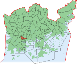
Alppiharju
|
Alppiharju (Åshöjden) district number 12 of Helsinki |
|
|---|---|
| Coordinates | 60 ° 11 '18 " N , 24 ° 56' 43" E |
| surface | 0.87 km² |
| Residents | 11,497 (Jan. 1, 2008) |
| Population density | 13,215 inhabitants / km² |
| structure | |
| Sub-areas |
Harju (12.1) |
| Source: Helsinki City Statistics Office: Helsinki alueittain 2006 (PDF, 12 MB, Finnish) | |
Alppiharju ( Swedish Åshöjden ) is a district ( kaupunginosa ) and at the same time also an urban district ( peruspiiri ) of the Finnish capital Helsinki .
The district borders in the north on the Aleksis Kiven katu on the district Vallila , in the east on Sörnäinen , in the west on the Helsinginkatu on the district on Kallio , in the southwest on Taka-Töölö and in the northwest on Pasila . Alppiharju is made up of the two sub-areas Alppi in the west and Harju in the east. A large part of the area is taken up by the Linnanmäki theme park, which opened in 1950, and the adjacent Alppipuisto park in the west of Alppiharju. To the west of this is the Helsinki Olympic Stadium in Taka-Töölö .
With a population density of 13,215 inhabitants / km², Alppihaju is the most densely populated district of Helsinki after Punavuori, Kallio and Ullanlinna. The average living space is around 37.8 m². The proportion of people under 16 is only 3%.
traffic
Several lines of the Helsinki tram run through the district. On the Helsinginkatu, which connects Taka-Töölö with Sörnäinen, trams on line 8 run between Jätkäsaari and Arabianranta . In the north-south direction, lines 1, 3, 7 and 9 run to the city center and Helsinki Central Station . The Pasila train station in the neighboring Pasila to the north can also be reached quickly.
gallery
The Brahen kenttä sports field ( Helsingfors IFK's bandy and football home ground ) and the Aleksis Kiven koulu school


