Lübbecke (core city)
|
Lübbecke core city
City of Luebbecke
Coordinates: 52 ° 18 ′ 9 ″ N , 8 ° 37 ′ 5 ″ E
|
|
|---|---|
| Height : | 104 m above sea level NN |
| Area : | 17.18 km² |
| Residents : | 15,934 (Dec. 31, 2007) |
| Population density : | 927 inhabitants / km² |
| Postal code : | 32312 |
| Area code : | 05741 |
|
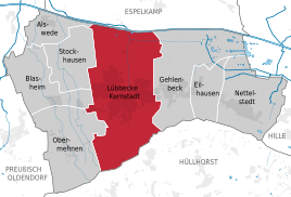
Location of Lübbecke Kernstadt in Lübbecke
|
|
Lübbecke Kernstadt is an area of Lübbecke in the Minden-Lübbecke district in East Westphalia . The core city, as a term therefore a bit misleading, von Lübbecke essentially comprises the area of the old city of Lübbecke before the territorial reform in 1973 and also includes larger forest and agricultural areas. Only small parts previously belonging to Lübbecke, which are located north of the Mittelland Canal, were removed from Lübbecke and incorporated into the city of Espelkamp in the course of the regional reform. In the south, however, the core city was able to record a significant gain in area: the reorganization brought uninhabited forest areas, the so-called Reineberger Hagen , with the area of the former Reineburg with an area of 0.99 km² to the city of Lübbecke, which previously belonged to the municipality of Ahlsen to the south -Reineberg had heard and reached up to the Obere Tilkenbreite. The mountain ridge has since formed the southern border to the municipality of Hüllhorst, or the Hüllhorst district of Ahlsen-Reineberg.
In § 3 of the main statute of the city of Lübbecke, the area of the core city is not defined or mentioned. Therefore, according to the main statute, it is not a village with a village chief. In general, Lübbecke Kernstadt is colloquially understood as a town, part of town or part of town and is therefore equated with towns. The term Lübbecke Kernstadt is also given, for example, by the city of Lübbecke in its population statistics. From this it emerges that Lübbecke Kernstadt includes that part of the city of Lübbecke that is not counted among the actual localities. As a result, Lübbecke core city largely corresponds to the city of Lübbecke with the territorial status before January 1, 1973. The core city of Lübbecke has around 16,000 inhabitants on 17.22 km² (around a quarter of the city area of Lübbecke and almost 62% of the residents of the city as a whole), is thus by far the largest district of Lübbecke and represents the urban core of the city of Lübbecke. In terms of area, the core city is almost congruent with the parish of Lübbecke .
The often mentioned term "City" of Lübbecke is not to be equated without further ado with the core city, since the city in the general understanding, as it is also shown with directional signs in road traffic, really only means the central area of Lübbecke in the area of the old town.
geography
The place Lübbecke lies in the Lübbecker Loessland on the northern edge of the Wiehengebirge, where it is cut through in its furthest north protruding part by a pass furrow. The city center is about 95 m above sea level and slopes down to the north.
The area of the core city does not only include the actual city, but extends from the ridge of the Wiehengebirge in the south to the Mittelland Canal in the north. The partial landscapes belong to the area
- Wiehengebirge in the south,
- the Lübbecker Loessland in the middle and
- the Rahden-Diepenauer Geest in the north, from around the federal highway 65 to the city limits on the Mittelland Canal .
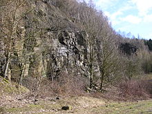
The core city thus has a share in all sub-landscapes of the "entire city" of Lübbecke. The southern mountainous third of the core city is almost completely covered by forest and uninhabited. Only the southernmost building plots on a hillside and a few industrial companies, such as the “Barre Bräu” brewery, are located in this sub-area. There are also smaller agriculturally used areas on the northern slope of the Wiehengebirge: around three hectares south of the Oberen Tilkenbreite and Reinburgstraße but also the Gallenkamp are grassland, the western part being used as meadow and the eastern part as pasture. The highest mountains of the Wiehengebirge ( Heidbrink , Wurzelbrink, etc.) are located in the area of the city center.
The actual housing estate is located in the central part (mainly in the natural area of the Lübbecker Lößland but also partly in the Rahden-Diepenauer Geest) and covers around 4.5 km² around a third of the core city, with the city, i.e. the old town, only 0.22 km², is located in the southern part of this third, which is justified by the fact that new building plots in the 20th century could hardly be developed to the south due to the reliefs, but only in the flat areas to the north. The area of the Lübbecker Loessland has hardly any undeveloped agricultural land in the city center. The only remaining arable land worth mentioning lies between the hospital and Bundesstrasse 65 (on both sides of Virchofstrasse) and is around 40 hectares in size.
In the limited available mountain locations near the forest in the far south (Schützenstraße, Am Gallenkamp, Obere Tilkenbreite, Osterstraße and others) are now the more exclusive residential areas . The northern settlement areas, especially north of the federal highway 65 and the railway line, were only opened up after the Second World War. Here, terraced house settlements and single houses with comparatively small properties, as well as a few high-rise complexes, are the determining element.
The northern third of the city center, which is already part of the Rahden-Diepenauer Geest, includes not only larger agricultural areas but also the Lübbeck industrial area . Part of the Rauhe Horst - Schäferwiesen nature reserve is also located here in the north of the city center. There is hardly any resident population in the north of Lübbeck and is limited to former farms or manor houses. Most of the factories and large companies as well as car dealerships, wholesalers etc. are located here, as well as the Lübbeck industrial port .
With around 925 inhabitants per km², the core city has a significantly higher population density than the rest of the city of Lübbecke. (In the entire city of Lübbecke an average of 400 people live on one km², in all other parts of the city, i.e. excluding the core city, there are only 211 inhabitants per km²). It should be noted here that the Wiehengebirge is uninhabited and the northern part of the core city is only marginally populated. In the Lübbeck industrial area, for example, only 230 people live on around 3.3 km², i.e. only 70 people / km². On the closed settlement area of the actual Lübbecke settlement on around 5 km² around 13,750 people, which means a population density of 2,750 inhabitants per km² for the central city area. Settlement is particularly dense in the historic old town, roughly delimited by the Niederwall in the north, the Bundesstrasse in the east, and Weingartenstrasse and Bahnhofstrasse in the west. Around 1,200 people live here on 25 hectares, which corresponds to a population density of 4,800 inhabitants / km². Dense development, the smallest of plots, usually without gardens, are driving the statistical settlement density up here. Only the fact that the numerous shops, the area around the church, the parking garages and the bus station are unpopulated, reduce the average population density there. People also live close together in the area on the other side of the railway embankment , i.e. north or west of the railway line: around 5,000 people are crowded here on 1.4 km², i.e. 3,571 inhabitants / km²; In contrast to the old town, many houses, albeit small ones, have gardens, which explains the slightly lower population density than in the old town. It is much more convenient to reside in villas on the above-mentioned hillside location in the far south, mostly on more spacious plots: the roughly 21 hectares of building land between Gallenkamp , the tennis club, the edge of the forest and the east end of the Upper Tilkenbreite are shared by just under, often well-heeled, 300 inhabitants, which corresponds to a population density of corresponds to only around 1,400 inhabitants / km².
Delimitation to the Gehlenbeck district
In the north, the outer border of the core city coincides with that of the city as a whole and runs along the Mittelland Canal. In the south the border of the core city coincides with the outer border of the city on the crest of the Wiehengebirge. There are no natural boundaries in the west. The end of the inner-city, closed development simplifies the assignment as far as possible. To the east to the Gehlenbeck district, however , the course of the border is not always obvious, since the development of this district now merges seamlessly into that of the core city. Therefore a more detailed description seems necessary:
The border of the city center bends from the canal at the bridge that connects “Heuweg” with “Fahrenhorster Straße” and runs from there in several bends for around 800 meters to the southeast, then for around 800 meters to the southwest, until it reaches the "Grapenstein" reached the Jägerbach. This Jägerbach or Jägergraben is followed by the border for 1.5 kilometers to the south to the B65 federal road. From there it runs for 90 meters on the aforementioned federal road to the east, then bends to the south and follows the course of "Siekenkampstraße" for 145 meters. Then it suddenly bends west for 140 meters, runs south for around 140 meters until it meets “Bleichstrasse”. It follows this for almost 90 meters to the west to the confluence with "Burkampstraße". It follows this east for around 235 meters to the confluence of the "Grenzweg". Characteristically, the Grenzweg then forms the border between the city center and Gehlenbeck for around 220 meters. At the end of the path, the border then runs for 250 meters approximately along the edge of the forest to the mountain forest of the Wiehengebirge east. From there, as expected, it turns south into the Wiehengebirge and after 1.8 kilometers, running over the summit of the Heidkopf , at the hut on the Heidbrink, it meets the outer boundary of the entire city to the municipality of Hüllhorst.
Breakdown
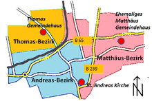
In its entirety, the core city itself does not represent de iure, but in fact a separate district. Administratively, the core city is therefore no longer divided into districts or districts. For objective reasons, however, the core city is divided into districts for different fields of activity, but each with a different number and layout. For the coordination of waste disposal z. B. forms the core town south of the B65, then with the districts Blasheim, Obermehnen, Stockhausen, Alswede, Nettelstedt, the district 1, everything north of the B 65 of the core town Lübbecke, together with Eilhausen and Gehlenbeck the district 2. The parish of Lübbecke is divided into three districts, the Thomas, Andreas and Matthäus district .
history
Population development
City of Luebbecke
|
|
Lübbecke core city
| year | Pop. | Inhabitant / km² |
|---|---|---|
| 1973 (January 1) | 11,453 | 667 |
| 1980 (unknown) ² | 12,000 | 697 |
| 2007 (Dec. 31) | 15,934 | 925 |
Footnotes
¹ census result (information for the current territorial status)
² Value cannot be proven, only from the memory of the author
³ Based on the area of 16.84 km² (6675 Prussian acres), from 1871 18.08 km², from 1910 17.19 km², 1972: 17.20 km², 1973: 17.18 km², from 1980 17.22 km² km²
Importance of the core city Lübbecke

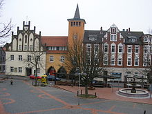
Around 62 percent of the residents of the entire city of Lübbecke live in the core city, the remaining 38 percent in the other seven districts. The core city Lübbecke is in the Minden-Lübbecke Minden addition, the only historical "real" city that already in the Middle Ages on the city charter disposal and at that time the characteristics of a city had (city walls, marketplace, etc.). All other cities in the district were either built in the 18th and 19th centuries, with the respective city centers still barely more than clustered villages today ( Rahden , Preussisch Oldendorf , etc.), or only in the 20th century, either through actual re-establishment ( Espelkamp , Bad Oeynhausen ) or received the necessary number of inhabitants for the town charter ( Petershagen restricted, Porta Westfalica ) due to the generous incorporation of various villages as part of the territorial reform of 1974 , without having really lost the village character. The core town of Lübbecke is therefore the undisputed cultural center of the former Lübbecke district today . In the district area, besides Minden, only the core town of Lübbecke has a historic old town with the typical concentration of pubs, restaurants and discos and a comparatively attractive tourist flair. (Church, old town houses).
Evangelical Lutheran Church Congregation
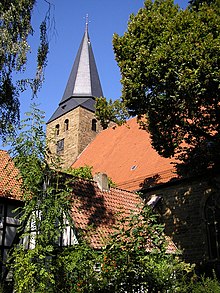
To the Evangelical Lutheran parish of Lübbecke, which is largely congruent with the city center (only the Obernfelde estate, which administratively belongs to the Obermehnen district, has always been parish off to Lübbecke) 8409 souls. Pastor Eberhard Helling currently chairs the presbytery of the parish . The municipality is divided into three districts around the Thomas parish hall, the Andreas parish hall and the Andreas church. The parish of Lübbecke belongs to the Lübbecke region, which includes the Evangelical Lutheran parishes of Blasheim, Gehlenbeck, Lübbecke and Nettelstedt, but not that of Alswede.
Web links
- Lübbecke in the Westphalia Culture Atlas
Footnotes
- ↑ Historical map (sketch) of the city of Lübbecke >> Reinegerger Hagen is outside the city
- ^ Heimatkreis Singkreis Ahlsen-Reineberg eV (Ed.): 700 years of Ahlsen. 1290–1990, Hille-Eickhorst, 1990, p. 85
- ↑ Data determined from residents of NRW - online calculator
- ↑ Lübbeckes waste calendar ( memento of October 24, 2011 in the Internet Archive )
- ↑ Petershagen became a so-called Minor town in 1320 , i.e. a place with limited rights of a town
- ↑ Statement on the website of the church district Lübbecke ( Memento of the original from August 14, 2013 in the Internet Archive ) Info: The archive link was automatically inserted and not yet checked. Please check the original and archive link according to the instructions and then remove this notice.
