La Chapelle-Montreuil
| La Chapelle-Montreuil | ||
|---|---|---|
|
|
||
| local community | Boivre-la-Vallée | |
| region | Nouvelle-Aquitaine | |
| Department | Vienne | |
| Arrondissement | Poitiers | |
| Coordinates | 46 ° 32 ' N , 0 ° 7' E | |
| Post Code | 86470 | |
| Former INSEE code | 86056 | |
| Incorporation | 1st January 2019 | |
| status | Commune déléguée | |
La Chapelle-Montreuil is a commune Déléguée in the French community Boivre-la-Vallée with 711 inhabitants (as of January 1 2017) in the department of Vienne in the region Nouvelle-Aquitaine (before 2016: Poitou-Charentes ).
The municipality of La Chapelle-Montreuil was merged with Benassay , Lavausseau and Montreuil-Bonnin on January 1, 2019 to form the Commune nouvelle Boivre-la-Vallée. Since then it has had the status of a Commune déléguée. The municipality of La Chapelle-Montreuil was part of the Arrondissement of Poitiers and the canton of Vouneuil-sous-Biard (until 2015: canton of Vouillé ).
geography
La Chapelle-Montreuil is located about 22 kilometers west-southwest of the city center of Poitiers on the Boivre . La Chapelle-Montreuil is surrounded by the villages of Montreuil-Bonnin in the north, Béruges in the east and north-east, Coulombiers in the south and south-east, Lusignan in the south, Jazeneuil in the south-west and Lavausseau in the west and north-west.
The A10 autoroute runs through the municipality .
Population development
| year | 1962 | 1968 | 1975 | 1982 | 1990 | 1999 | 2006 | 2013 |
|---|---|---|---|---|---|---|---|---|
| Residents | 625 | 533 | 489 | 487 | 500 | 565 | 608 | 688 |
| Source: Cassini and INSEE | ||||||||
Attractions
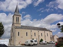
- Saint-Eutrope church

