La Paz Robles
| La Paz Robles | ||
|---|---|---|
|
Coordinates: 10 ° 23 ′ N , 73 ° 10 ′ W La Paz Robles on the map of Colombia
|
||
|
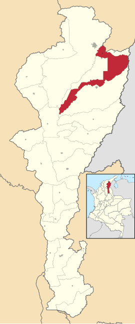
Location of the municipality of La Paz Robles on the map of Cesar
|
||
| Basic data | ||
| Country | Colombia | |
| Department | Cesar | |
| City foundation | 1775 | |
| Residents | 23,025 (2019) | |
| - in the metropolitan area | 594,677 | |
| City insignia | ||
| Detailed data | ||
| surface | 1081 km 2 | |
| Population density | 21 people / km 2 | |
| height | 165 m | |
| Time zone | UTC -5 | |
| City Presidency | Andrea Doria Ovalle (2016-2019) | |
| Website | ||
La Paz Robles , also briefly La Paz , is a municipality ( municipio ) in the department of Cesar in Colombia . La Paz Robles belongs to the metropolitan area of Valledupar , the metropolitan area of Valledupar .
geography
La Paz Robles is located in the north of the Departamento del Cesar 12 km from Valledupar at an altitude of 165 meters and has an average temperature of 11 to 37 ° C. The municipality is bordered by La Jagua del Pilar in La Guajira in the north, Manaure in the northeast , the state of Zulia in Venezuela in the east, Agustín Codazzi in the south, El Paso in the southwest , San Diego in the west and Valledupar in the north-west.
population
The municipality of La Paz Robles has 23,025 inhabitants, of which 15,271 live in the urban part (cabecera municipal) of the municipality. 594,677 people live in the metropolitan region (as of 2019). The east of the community near the Serranía del Perijá is inhabited by the indigenous people of the Yukpa .
history
La Paz was founded in 1775 by cattle farmers in the region. The Magdalena Department founded in 1888 the church Espíritu Santo (the present Agustín Codazzi ), belonged to the La Paz. In 1936 the community in honor of Luis Rafael Robles was in Robles renamed and moved the seat of the municipality of La Paz. When the Departamento del Cesar was founded in 1967, La Paz remained the seat of the municipality of the same name.
economy
The main industries of La Paz Robles are cattle production , the production of almojábanas (cheese and corn rolls) and agriculture ( coffee , onions and cocoa ).
Web links
- Alcaldia de La Paz Robles. Alcaldía de La Paz Robles - Cesar, accessed February 11, 2019 (Spanish, municipality website).
Individual evidence
- ↑ a b Información del municipio. Alcaldía de La Paz Robles - Cesar, accessed February 11, 2019 (Spanish, information on the geography of the municipality).
- ↑ ESTIMACIONES DE POBLACIÓN 1985 - 2005 Y PROYECCIONES DE POBLACIÓN 2005 - 2020 TOTAL DEPARTAMENTAL POR ÁREA. (Excel; 1.72 MB) DANE, May 11, 2011, accessed on February 11, 2019 (Spanish, extrapolation of the population of Colombia).
- ↑ Pasado, presente y futuro. Alcaldía del Municipio de La Paz Robles - Cesar, accessed February 11, 2019 (Spanish, information on the history of the municipality).
- ↑ Economía. Alcaldía de La Paz Robles - Cesar, accessed February 11, 2019 (Spanish, information on the economy of the municipality).


