Lake Effect
The Lake Effect is a meteorological effect that occurs primarily in the Great Lakes region in North America . It often causes intense precipitation , mostly in the form of snow . This is then referred to as Lake Effect Snow or Snowsquall . There is no German term for this phenomenon. In early winter, extremely cold air over water surfaces that are still quite warm in summer can lead to strong thunderstorms , which are known as thunder snow . But even when there is no precipitation, cold air over warmer water always causes heavy cloudiness over the southeastern shores of the Great Lakes, which is why the term The Great Gray Funk is used here as a synonym for winter. As a result of the lack of light, winter depression often occurs in these areas .
Similar snowfalls can also occur near large inland bays, where they are then referred to as Bay Effect Snow . If the cause is an area of low pressure in the ocean, which directs humid and unstable air masses onto the coastal areas, often against the prevailing wind direction, this is also referred to as ocean effect snow .
Emergence
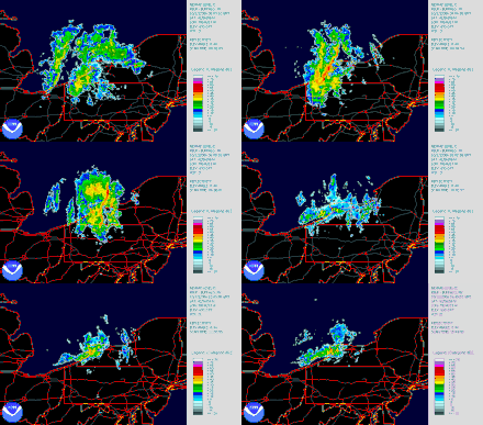
This effect occurs when cold winds blow over large areas of lake with warm water in winter . Water vapor is absorbed above the lake , but it freezes quickly and falls as snow on the lee bank of the lake . The effect is intensified by orographically induced upward movements of the air flow against the wind direction, which can lead to narrow but very intensive bands of precipitation with deposition rates of several decimeters of snow per hour (see right).
Cold air winds typically blow from west-southwest to northwest in winter in the northern west wind zone , which is why the heaviest snowfalls occur on the northeast to southeast shores of the lakes. The result is a significant difference in the amount of precipitation on the opposite bank and its immediate hinterland. If the air temperature is not low enough to keep the water frozen, the precipitation shows up as lake effect rain.
The weather records of the Tug Hill Plateau in the southeast of Lake Ontario consistently show the highest snowfall values in the entire USA. Another example is the area in the southeast of Lake Erie , with an approximate extension from Cleveland to South Buffalo , whereby Lake Erie also freezes slightly due to its shallow depth and the effect then no longer shows. Lake Effect Snow can also occur on the south and south-east coast of the Great Salt Lake in Utah, but this is much less pronounced here than in comparison to the Great Lakes. These areas of influence of lake-effect snow is known in English as Snowbelt ( German , snow belt ' ). The snow belt with the largest population of Lake Effect Snow is located in the Upper Peninsula of Michigan , near the cities of Houghton , Marquette and Munising . These areas often have snow depths of an average of 5 or even 7.5 meters per year, but due to their low population they do not reach the level of awareness of the other areas around the Great Lakes. Since the adjacent Lake Superior seldom freezes over due to its size and depth, the effect here often shows itself continuously over the entire winter months.
Lake Effect in Germany
In Schleswig-Holstein, the effect last brought large amounts of snow on March 11, 2013, when the city of Lübeck was particularly affected. In some parts of the city it snowed continuously for more than 24 hours, which resulted in more than 50 cm of fresh snow locally. Previously, this effect already occurred on November 30, 2010 in the central part of the Ostholstein district , when polar easterly winds over the warmer Bay of Lübeck briefly led to snow depths of up to 76 cm and significantly higher snowdrifts, so that the traffic on the roads collapsed. The lake effect occurs in Germany mainly on the coasts and in the western low mountain ranges on lakes such as B. in the Sauerland. In weak forms, the North Sea and Baltic Sea often provide snow in the neighboring federal states, especially in hilly Holstein Switzerland with north-easterly winds. A temperature difference of a little more than 10 ° C between the 850 hPa level and the water temperature is often sufficient for the onset of precipitation, and if the wind direction remains constant over a longer period of time, some precipitation can accumulate near the coast even with a relatively low precipitation rate. The last time there were such events were in March 2018 and November 2016, which resulted in up to 40 cm of fresh snow in Ostholstein and Western Pomerania within a few hours.
Lake Effect in Turkey
Especially in the Bosporus region (including Istanbul ) and in the western Black Sea region (e.g. around Zonguldak ), strong cold air ingress from the north over the warmer Black Sea leads to prolonged, heavy snowfalls. It is not uncommon for large amounts of snow to fall in the metropolitan area of Istanbul. In the past, strong winds also caused meter-high snowdrifts , for example during the snow catastrophe in March 1987. At that time, it was snowing for days in Istanbul and the snow was meter-deep.
Web links
supporting documents
- Lake effect in the WetterOnline weather dictionary
- ↑ 60 centimeters of snow: Chaos in Ostholstein and Segeberg ( Memento from March 8, 2011 in the Internet Archive ) - Lübecker Nachrichten
- ↑ Weather and Climate - German Weather Service - Press - Weather in Germany in 2018. Accessed on May 26, 2019 .
- ^ The Black Sea impact on the severe snow episode over the city of Istanbul

