Landgraben (Dresden)
In the Saxon state capital Dresden, the name Landgraben traditionally describes the lower section of the water system known in the official parlance Blasewitz-Grunaer Landgraben / Koitschgraben / Leubnitzbach , which starts on the heights south of the Leubnitz-Neuostra district and flows into the Elbe in the Blasewitz district .
Definition
The general generic term Landgraben applies to a number of small flowing waters or channels in today's Dresden city area. Similar to a proper name, the expression established itself primarily in relation to the watercourse that flows through the former village (now the district) of Gruna .
From Gruna upwards, the name Landgraben can be documented using historical maps along a western tributary to Dohnaer Straße not far from the old village center of Leubnitz-Neuostra and along an eastern tributary through Prohlis to Nickern . The eastern tributary, a continuation of the Geberbach and today officially called Prohliser Landgraben , has had no connection with the Gruna section since the beginning of the 20th century. The western tributary, a continuation of the Leubnitzbach , bears the name Kotzschgraben (later Koitzschgraben , today officially Koitschgraben ) in addition to the name Landgraben .
A water profile published by the state capital Dresden in 2012 assigns the names to the water sections as follows:
- Leubnitzbach: from the confluence of Britschengraben / Zauchgraben to Dohnaer Straße
- Koitschgraben: from Dohnaer Straße to the crossing under the Děčín – Dresden railway line
- Blasewitz-Grunaer Landgraben: from the railway crossing to the confluence with the Elbe
In contrast to this, individual historical maps or city maps also used the term Landgraben for the Niedersedlitzer flood ditch and the term Prohliser Landgraben also for the section below Gruna.
course
The Landgraben or Koitschgraben begins at the mouth of a pipeline roughly on the border between the properties Dohnaer Straße 133 / 133a and 135, about ten meters north of Dohnaer Straße. The water that emerges there comes from the Leubnitzbach , which enters the piping about 300 meters into town on the southern edge of the road. The first section of the trench runs rather hidden in the middle of an industrial and commercial area towards the northeast and is only about 150 meters long, followed by a piped section about 100 meters long. Not far from the Otto-Dix-Ring road, the watercourse comes to the surface again and swings sharply to the east, while the 0.74 km long, only episodically water-bearing Leubnitzer Mittelgraben flows into it from the left . Then it turns again to the northeast and takes up the Torna ditch near the Seebachstraße at an acute angle from the right (south) .
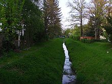
In this area and on the following kilometer, the water appears to be natural. This is the result of a redesign that was carried out between 2010 and 2012, the main aim of which was to improve the safe discharge of a so-called 100-year flood (HQ 100). At the same time, on this occasion, the trench was brought closer to a natural state and provided with an accessible bank area through the irregular formation of the bottom and embankment as well as the introduction of stone blocks and site-appropriate vegetation. Before and during the 20th century, it presented itself in this section, as in the rest of its course, as a monotonous canal with a trapezoidal cross-section.
Between Strehlen and Reick, the ditch forces the Reicker Straße that bridges it to form an elongated elevation. To the north of Reicker Straße it passes the demolished wasteland of the former prefabricated housing estate Rudolf-Bergander-Ring as well as an area left to natural succession, where the river bed has been widened to form an approximately 0.5 hectare basin. A few meters after emerging from this hollow, the trench is led in a man-high concrete tunnel through the embankment of the Děčín – Dresden railway line . Shortly afterwards, piping about 300 meters long follows on the premises of the Dresden-Reick thermal power station of DREWAG .
After crossing under the southern end of Liebstädter Straße , the upper edges of the ditch embankments rise increasingly above the surrounding level, after which the ditch crosses two prehistoric drainage channels of the Elbe. Between Winterbergstrasse and Bodenbacher Strasse in the area of the southern old Elbarme, the elevation reaches more than two meters and is again noticeable as a striking hill in the course of the two streets. At the eastern edge of the Rothermundtpark it flattens out a bit, only to rise again when crossing the northern Altelbarmes at the level of Calvinstrasse. The course of the trench was changed at this point in 1875. To the south of the garden home settlement , the bottom of the trench is even higher than the neighboring terrain. There it bends at right angles to the southeast and after about 300 meters just as sharply again to the northeast. At the southern end of the street Grabenwinkel, whose name derives from this turning, a small staircase leads up to the edge of the ditch. The high position of the trench ends when it emerges from the lowland in the Hepkestrasse area.
The Landgraben then runs parallel to Lauensteiner Straße, mostly relatively inaccessible and hidden behind the buildings along the property lines facing away from the street. The edge of the ditch is only accessible for a few hundred meters along the Striesen cemetery . However, views of the moat are possible from several cross streets that span it. At the level of Niederwaldstraße the ditch bends again at right angles to the southeast, intersects the northern tip of Niederwaldplatz, takes the northeast direction east of the former Blasewitz road station again and, after crossing under Tolkewitzer Straße, reaches the embankment of the Elbe. Since the bottom of the trench is several meters higher than the normal Elbe level, the last section of the land trench along the short Spohrstrasse has a considerable gradient. In the past, the descent was via three crash structures, which formed an insurmountable obstacle to migration for aquatic organisms. In 2012 this barrier was dismantled and replaced by a multi-step cascade staircase.
Course in previous centuries


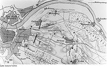
The map series of the first Electoral Saxon state survey , made between 1586 and 1614 by Matthias Oeder and further processed by Balthasar Zimmermann until 1634, shows a river bifurcation (branching) of the stream flowing through Leubnitz north of Leubnitz-Neuostra . The western branch of the river is labeled “Graben” and after a short run flows into the Kaitzbach system . The eastern branch with the inscription "The old brook" runs identically to the water body called "Landgraben" in later illustrations through Gruna and Striesen to the Elbe. A connection with the watercourse coming from Nickern via Prohlis is not yet visible in the Oederschen map, this continues on its way to the northeast through Reick , Dobritz and Tolkewitz to the Elbe.
In several maps drawn towards the end of the 18th century, the eastern Leubnitzbacharm ends shortly after the branch. Its former continuation, the watercourse now labeled Landgraben , in the upper reaches also Kotzschgraben , has established a connection with the western Leubnitzbacharm via the Mittelgraben . In addition, it joins the Prohliser watercourse south of Gruna, which at Reick has swung from its (according to Oeder) former north-east to a north-west direction and is now also called "Landgraben".
Further down, the maps show a continuous course from the 17th to the 19th century: south of the village of Gruna, the ditch crosses the southern old Elbarm at approximately right angles and bypasses a lake or swamp that was still stretching in this lowland at that time. To the east of the town center, it swings with a sharp bend to the west into the northern Altelblauf, taking in the Plantzschgraben coming from the east from the Seidnitz location . Then it follows the old river bed in a wide quarter-circle arc to the village of Striesen, where it turns back to the west in the area between today's Eilenburger and Schandauer Straße. Here the Landgraben separated the local developments of Neustriesen from the old farming village of Striesen and flowed parallel (north) of today's Holbeinstrasse towards Eliasfriedhof . In the area of the northern Fetscherstrasse, he took up the Kaitzbach flood ditch, which is no longer visible today , which ensures the irrigation of the Carola and New Lakes in the Great Garden . South of the Elias cemetery, the ditch reached the Pirnaische Vorstadt at the former Ziegelschlag and then turned north to the former brick barns, where it flowed into the Elbe.
In the 1870s, the ditch from Gruna was given a new course in the direction of Blasewitz . Then the equidistant maps and measuring table sheets of Saxony as well as Dresden city maps document the gradual dismantling of the Gruna-Striesener section from the west, the last relics are recorded in Gruna until the 20th century. A little later, the closure and leveling of the Prohliser tributary can be observed in a similar way, the water of which has since been directed from Reick to Leuben into the Niedersedlitzer flood ditch . At the same time, the inflow from the eastern arm of the Leubnitzbach revived, but the connection to the western arm was interrupted.
Purpose and use
The Landgraben records the runoff of the southern slopes of the Elbe valley from Leubnitz-Neuostra to Torna (previously to Nickern) and leads it to the Elbe on a route that more or less deviates from the natural gradient. Since the trench was built in the Middle Ages (probably by German settlers around 1300), the water has been prevented from entering the somewhat deepened old Elbe courses and instead led through the higher-lying settlement cores. In this way, the lowlands were gradually drained and initially used for agriculture, and since the 20th century they have been increasingly built over, while the moat continued to at least provide the villages with service water.
In the present, water abstraction and use no longer play a role. In the event of heavy precipitation, the ditch also serves as a receiving water for mixed water relief from the urban sewer system. The Koitschgraben section was made accessible as a public space in the course of the renaturation .
swell
- Blasewitz-Grunaer Landgraben / Koitschgraben / Leubnitzbach water profile (PDF, 3.84 MB) from www.dresden.de, accessed on August 22, 2016
- Alfred Hahn, Ernst Neef : Dresden = Values of our Homeland Volume 42, Academy of Sciences of the GDR , Institute for Geography and Geoecology, Local Research Working Group, 2nd edition, Akademie-Verlag, Berlin, 1985
- Folke Stimmel et al .: Stadtlexikon Dresden A – Z. Verlag der Kunst, Dresden 1995, ISBN 3-364-00300-9 .
Web links
Individual evidence
- ^ "Ur-Oeder" sheet 181, area south-east of Dresden , 1586 to 1634, scale 1: 13333, digitized Deutsche Fotothek. (The inscriptions are easier to read in this hand drawing.)
- ^ "Oeder-Zimmermann-Karte", collotype facsimile from 1889 , scale 1: 53333, digitized by the Deutsche Fotothek. (In this reproduction the course of the water can be seen better.)
- ^ Equidistant map Section Dresden, 1881 , digitized Deutsche Fotothek (The new run to Blasewitz is in operation, the old run only extends as far as Altstriesen.)
Coordinates: 51 ° 2 ′ 47 " N , 13 ° 48 ′ 53" E


