Lanzing (community of Dunkelsteinerwald)
|
Lanzing ( hamlet ) locality cadastral community Lanzing |
||
|---|---|---|
|
|
||
| Basic data | ||
| Pole. District , state | Melk (ME), Lower Austria | |
| Judicial district | Melk | |
| Pole. local community | Dunkelsteinerwald | |
| Coordinates | 48 ° 13 '54 " N , 15 ° 26' 41" E | |
| height | 372 m above sea level A. | |
| Residents of the village | 12 (January 1, 2020) | |
| Area d. KG | 1.11 km² | |
| Statistical identification | ||
| Locality code | 04546 | |
| Cadastral parish number | 14132 | |
| Counting district / district | Wall near Melk (31507 003) | |
| Source: STAT : index of places ; BEV : GEONAM ; NÖGIS | ||
Lanzing is a place and a cadastral municipality of the market town of Dunkelsteinerwald , Lower Austria.
The hamlet is located three kilometers east of Mauer bei Melk and can be reached via the L5359 state road. The Kronhof single vineyard is also located in the village of Lanzing . On January 1st, 2020 there were 12 residents in the village. In the Franziszeischen cadastre from 1822 Lanzing is listed with four farms.
Culture and sights
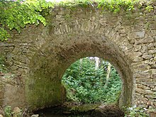
- Römerbrücke (location: 48 ° 14 ′ 6 ″ N , 15 ° 26 ′ 29 ″ E ): the construction probably falls in the 3rd or 4th century AD.
literature
- List of places 2001 Lower Austria , Statistics Austria, Vienna 2005, PDF , mentioned on page 195
Individual evidence
- ^ Franziszeischer Cadastre (around 1820): Lanzing ( online on mapire.eu ).


