Dunkelsteinerwald (municipality)
|
market community Dunkelsteinerwald
|
||
|---|---|---|
| coat of arms | Austria map | |
|
|
||
| Basic data | ||
| Country: | Austria | |
| State : | Lower Austria | |
| Political District : | Melk | |
| License plate : | ME | |
| Main town : | Gansbach | |
| Surface: | 54.28 km² | |
| Coordinates : | 48 ° 18 ' N , 15 ° 28' E | |
| Height : | 585 m above sea level A. | |
| Residents : | 2,393 (Jan 1, 2020) | |
| Population density : | 44 inhabitants per km² | |
| Postal code : | 3392 | |
| Area code : | 02753 | |
| Community code : | 3 15 07 | |
| NUTS region | AT121 | |
| Address of the municipal administration: |
3392 Gerolding | |
| Website: | ||
| politics | ||
| Mayor : | Franz Penz ( ÖVP ) | |
|
Municipal Council : ( 2020 ) (21 members) |
||
| Location of Dunkelsteinerwald in the Melk district | ||
| Source: Municipal data from Statistics Austria | ||
Dunkelsteinerwald is a market town with 2393 inhabitants (as of January 1, 2020) in the Melk district in Lower Austria .
geography
Dunkelsteinerwald is located in the Mostviertel in Lower Austria. The area of the market town covers 54.19 square kilometers. 46.73 percent of the area is forested.
Community structure
The municipality includes the following 33 localities (population in brackets as of January 1, 2020):
- Aichberg (24)
- Broom Book (52)
- Bichl (4)
- Bittersbach (5)
- Durnbach (8)
- Eckartsberg (14)
- Gansbach (503)
- Gerolding (239)
- Houseling (89)
- Heitzing (18)
- Hessendorf (34)
- Himberg (97)
- Hohenwarth (25)
- Kicking (61) including Daxberg
- Kochholz (89) including Dürnberg and Im Liagl
- Krapfenberg (14)
- Lanzing (12)
- Lerchfeld (27)
- Lottersberg (36)
- Maierhöfen (18)
- Wall near Melk (591)
- New Gerolding (52)
- Neuhofen (89)
- Nolling (40)
- Nonnenhöfe (6)
- Oed (34)
- Ohnreith (5)
- Pfaffing near Mauer (23)
- Tiller yards (20)
- Schwaigbichl (3)
- Thal (57)
- Umbach (33)
- Origin (71)
The community consists of the cadastral communities Eckartsberg, Gansbach, Gerolding, Geroldinger Wald , Häusling, Heitzing, Hessendorf, Himberg, Hohenwarth, Kicking, Kochholz, Krapfenberg, Lanzing, Lerchfeld, Lottersberg, Mauer , Neuhofen , Nölling, Ohnreith, Pfaffing, Thal, Umbach and origin.
Neighboring communities
| Bergern ( Krems ) | Wölbling ( St. Pölten ) | |
| Schönbühel-Aggsbach |

|
Obritzberg-Rust ( St. Pölten ), Karlstetten ( St. Pölten ) |
| Melk | Loosdorf |
Hafnerbach ( St. Pölten ), Haunoldstein ( St. Pölten ) |
history
In ancient times, the area was part of the Noricum province .
The community was created in 1970 through the merger of the communities of Gansbach, Gerolding, Kicking and Mauer.
Population development
According to the results of the 2001 census , there were 2289 inhabitants. In 1991 the market town had 2025 inhabitants, in 1981 1941 and in 1971 1911 inhabitants.
coat of arms
- Description: In a shield base that points over a green, three- pointed shield , split from red to silver with a silver paw cross in front and a green conifer in the back.
- Colors: red-white-green
- Awarded: June 30, 1982.
politics
The municipal council has 21 members.
- With the municipal council elections in Lower Austria in 1990, the municipal council had the following distribution: 17 ÖVP, and 4 SPÖ.
- With the municipal council elections in Lower Austria in 1995, the municipal council had the following distribution: 15 ÖVP, 4 SPÖ, and 2 FPÖ.
- With the municipal council elections in Lower Austria in 2000, the municipal council had the following distribution: 14 ÖVP, 4 SPÖ, 2 FPÖ, and 1 Greens.
- With the municipal council elections in Lower Austria in 2005 , the municipal council had the following distribution: 15 ÖVP, 5 SPÖ, and 1 Greens.
- With the municipal elections in Lower Austria in 2010 , the municipal council had the following distribution: 15 ÖVP, 3 SPÖ, 2 FPÖ, and 1 Greens.
- With the municipal council elections in Lower Austria 2015 , the municipal council had the following distribution: 15 ÖVP, 2 FPÖ, 2 SPÖ, 1 Greens, and 1 FRANZ.
- With the municipal council elections in Lower Austria 2020 , the municipal council has the following distribution: 13 ÖVP, 4 SPÖ, 2 List Sedlmayer (FRANZ) and 2 Greens.
- mayor
- since ? Franz Penz (ÖVP)
Culture and sights
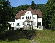
- Grabenhof Castle : a two-story building from the 15th / 16th centuries. Century.
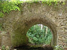
- Roman bridge near Lanzing (location: 48 ° 14 ′ 6 ″ N , 15 ° 26 ′ 29 ″ E ): it was built probably in the 3rd or 4th century AD.
- Parish church Gerolding : The Gothic pulpit , the wall fresco from the 17th century and the Gothic presbytery with the Gothic "session niche" are worth seeing .
- Parish church Gansbach: The church probably dates from the 14th century. The side altar picture by the famous painter Kremser Schmidt and the high altar picture, which was painted by one of his students, are worth seeing .
- Wall pilgrimage church : The carved altar (1509) from Mauer near Melk is a late Gothic miracle . The life of Mary in its most important stages is shown on the wings . The Gothic tabernacle is also very interesting.
- At Häusling there is a Roman quarry where Häusling marble was quarried .
In June 2018, the Falco sculpture “Is the comet coming or is it too late” by Katrin Plavčak was unveiled in Gansbach . The starting point for the idea for the scene sculpture was a line of text from the song Nur mit dir from Falco's album Junge Roemer . The monument consists of a four-meter-high, black and silver-colored sculpture made of steel and a serpentinite from the Dunkelsteinerwald , which represents a comet . The memorial was erected on the new Falco-Platz by the municipality together with the state of Lower Austria and the Art in Public Space Initiative .
nature
The wild roses , which occur in numerous species here, are typical of the Dunkelsteinerwald . The flowers are used for the production of liqueur, caster sugar, syrup and wild rose ice cream. The rose hips are also processed into various products such as jam , liqueur or puree . In order to preserve these cultures and to be able to market them better, the municipality with eight producers was added to the ranks of Austria's culinary regions in 2013 as the Dunkelsteiner Rosehip region .
economy
In 2001 there were 62 non-agricultural workplaces, agricultural and forestry operations 167 according to the 1999 survey. According to the 2001 census, the number of people in employment in the place of residence was 1017. In 2001, the activity rate was 46.22 percent.
Web links
- 31507 - Dunkelsteinerwald (municipality). Community data, Statistics Austria .
Individual evidence
- ↑ Statistics Austria: Population on January 1st, 2020 by locality (area status on January 1st, 2020) , ( CSV )
- ^ Result of the local council election 1995 in Dunkelsteinerwald. Office of the Lower Austrian State Government, March 30, 2000, accessed on September 17, 2019 .
- ^ Election result of municipal council election 2000 in Dunkelsteinerwald. Office of the Lower Austrian State Government, February 4, 2005, accessed on September 17, 2019 .
- ^ Election result of the local council election 2005 in Dunkelsteinerwald. Office of the Lower Austrian State Government, March 4, 2005, accessed on September 17, 2019 .
- ^ Election result of the local council election 2010 in Dunkelsteinerwald. Office of the Lower Austrian State Government, October 8, 2010, accessed on September 17, 2019 .
- ^ Election result of the 2015 municipal council election in Dunkelsteinerwald. Office of the Lower Austrian State Government, December 1, 2015, accessed on September 17, 2019 .
- ↑ Results of the local council election 2020 in Dunkelsteinerwald. Office of the Lower Austrian State Government, January 26, 2020, accessed on March 15, 2020 .
- ↑ Exhibitions, museums, art in public space . Office of the Provincial Government of Lower Austria, May 30, 2018.
- ↑ NÖN: Dunkelsteinerwald: Gansbach: Memorial for Falco in Dunkelsteinerwald . Article dated May 3, 2018, accessed June 2, 2018.
- ^ Arge Dunkelsteinerwald , accessed on March 8, 2013.
-
↑ Dunkelsteiner rose hip . Entry in the register of traditional foods of the Austrian Federal Ministry for Agriculture, Regions and Tourism .
Dunkelsteiner rosehip at the Genuss Region Österreich association .


