
Zelking-Matzleinsdorf
|
Zelking-Matzleinsdorf
|
||
|---|---|---|
| coat of arms | Austria map | |
 |
|
|
| Basic data | ||
| Country: | Austria | |
| State : | Lower Austria | |
| Political District : | Melk | |
| License plate : | ME | |
| Main town : | Zelking | |
| Surface: | 21.17 km² | |
| Coordinates : | 48 ° 11 ' N , 15 ° 15' E | |
| Height : | 238 m above sea level A. | |
| Residents : | 1,220 (January 1, 2020) | |
| Population density : | 58 inhabitants per km² | |
| Postal code : | 3393 | |
| Area code : | 02752 | |
| Community code : | 3 15 50 | |
| NUTS region | AT121 | |
| Address of the municipal administration: |
Pöchlarnerstraße 4 3393 Zelking-Matzleinsdorf |
|
| Website: | ||
| politics | ||
| Mayor : | Gerhard Bürg ( ÖVP ) | |
|
Municipal Council : ( 2015 ) (19 members) |
||
| Location of Zelking-Matzleinsdorf in the Melk district | ||
  |
||
| Source: Municipal data from Statistics Austria | ||

Zelking-Matzleinsdorf is a municipality with 1220 inhabitants (as of January 1, 2020) in the Melk district in Lower Austria .
geography
Zelking-Matzleinsdorf is located in the Mostviertel in Lower Austria and belongs to the Melk district . It is part of the Melktal small region. The municipality -type region ranges from Hiesberg the Melkfluss along up to the Danube and thus covers an area of 21.16 square kilometers. 34.78 percent of the area is forested.
Community structure
The municipality includes the following 11 localities (population in brackets as of January 1, 2020):
- Anzenberg (28)
- Arb (31)
- Bergern (32)
- Einsiedl (8)
- Freiningau (35)
- Alleys (104)
- Hofstetten (37)
- Maierhöfen (13)
- Mannersdorf (110) including Wolfersdorf
- Matzleinsdorf (543) including Mösel
- Zelking (279)
The community consists of the cadastral communities Bergern-Maierhöfen, Frainingau, Mannersdorf bei Zelking, Matzleinsdorf and Zelking.
Neighboring communities
.svg)
history
The name of the place Matzleinsdorf is mentioned as early as 1117. Finds prove a Roman settlement in the area. In 1693 the Matzleinsdorf branch was incorporated into Melk Abbey. It has existed as a separate parish since 1784. After its destruction in the Turkish year 1683 in the 18th century, the place burned down a total of five times, partly in its entirety, and was repeatedly rebuilt. In the immediate vicinity of Matzleinsdorf, apart from the parish church and the branch church in Maierhöfen, there are two more culturally and historically important places to visit, the "White Stone" (former border stone of Bavaria and the Wendenland) and the weir on the Müllnerkogel.
The Zelking ruin is located on the Melk River, a building by the free Hagenau family from the 11th century. In the 12th century the castle came into the possession of the Zelkingers , who also acquired the Schallaburg around 1270 . The long-lived family died out in 1634 with Ludwig Wilhelm von Zelking. From this the castle came to the Counts of Sinzendorf, 1802 to the Counts Harrach von Rohrau, around 1900 to the Heussenstamm family and finally in civil ownership. Outside of Zelking you can visit other old fortifications, the castle stables and the Hausberganlage in Arb. In 1970 the communities of Zelking and Matzleinsdorf were united.
In 1998 the coat of arms was awarded by the state government, mainly based on the design by Ludwig Pichler.
Population development
According to the results of the 2001 census, there were 1227 inhabitants. In 1991 the community had 1,196 inhabitants, in 1981 1253 and in 1971 1152 inhabitants.
politics
The municipal council has 19 members.
- With the municipal council elections in Lower Austria in 1990, the municipal council had the following distribution: 14 ÖVP, 4 SPÖ and 1 FPÖ.
- With the municipal council elections in Lower Austria in 1995, the municipal council had the following distribution: 14 ÖVP, 4 SPÖ and 1 FPÖ. Enter the unformatted text here
- With the municipal council elections in Lower Austria in 2000, the municipal council had the following distribution: 14 ÖVP, 4 SPÖ and 1 FPÖ.
- With the municipal council elections in Lower Austria in 2005 , the municipal council had the following distribution: 13 ÖVP and 6 SPÖ.
- With the municipal council elections in Lower Austria in 2010 , the municipal council had the following distribution: 12 ÖVP, 5 SPÖ and 2 FPÖ.
- With the municipal council elections in Lower Austria 2015 , the municipal council has the following distribution: 12 ÖVP, 5 SPÖ and 2 FPÖ.
- mayor
- until 2006 Leopold Labenbacher (ÖVP)
- since 2006 Gerhard Bürg (ÖVP)
Culture and sights
- Matzleinsdorf
- Catholic parish church hl. Bartholomew and cemetery and rectory
- '' Matzleinsdorf Castle: Former noble farm, later converted to baroque style and expanded to look like a castle
- Large villa from 1892 to 1894 by architect J. Blieweis for Anton Graf von Heussenstamm in an enclosed garden
- Zelking
- Catholic parish church hl. Erhard
- Burgruine Zelking : family seat of the Zelkinger
economy
Around a quarter of the population lives from or in agriculture .
In terms of businesses, there is a department store (Nah and Frisch), a few businesses, a tax advisor and two restaurants, Landgasthof Erber and Gasthaus Schaider.
- A traction current converter plant has been located in the Bergern district since 1983. At 48 ° 13'5.6 "N 15 ° 16'9" E there is also an 87-meter-high directional radio tower as a free-standing steel framework construction.
- tourism
There are hiking trails that lead through the hilly landscape as well as historical buildings and places within the community.
Personalities
- Josef Laßletzberger (1862–1939), Austrian military bandmaster and composer
- Johann Penz (* 1950 in Maierhöfen), Austrian politician (ÖVP) and since 2008 President of the Nö. Diet
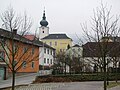
View from the village square of Matzleinsdorf to the Kirchenberg

Zelking Parish Church


Web links
- Official website of the community of Zelking-Matzleinsdorf
- 31550 - Zelking-Matzleinsdorf. Community data, Statistics Austria .
- Information collected by Mr. Ludwig Pichler, u. a. the family of the Zelking, the parish churches, legends and stories about Zelking etc.
Individual evidence
- ↑ Statistics Austria: Population on January 1st, 2020 by locality (area status on January 1st, 2020) , ( CSV )
- ↑ Entry about Zelking castle ruins in Lower Austria castles online - Institute for Reality Studies of the Middle Ages and Early Modern Times, University of Salzburg
- ↑ Entry about Burgstall Arb on NÖ-Burgen online - Institute for Reality Studies of the Middle Ages and Early Modern Times, University of Salzburg
- ↑ Orte> Zelking ( Memento of the original from August 14, 2016 in the Internet Archive ) Info: The archive link was inserted automatically and has not yet been checked. Please check the original and archive link according to the instructions and then remove this notice. zelking.com, Ludwig Pichler, © 2016, accessed August 14, 2016. - Draft coat of arms.
- ↑ The coat of arms of the community of Zelking-Matzleinsdorf (and the "successes" ...) ( Memento of the original from August 14, 2016 in the Internet Archive ) Info: The archive link was automatically inserted and not yet checked. Please check the original and archive link according to the instructions and then remove this notice. zelking.com, Ludwig Pichler, © 2016, accessed August 14, 2016.
- ^ Result of the municipal council election 1995 in Zelking-Matzleinsdorf. Office of the Lower Austrian State Government, March 30, 2000, accessed on October 26, 2019 .
- ^ Election result of the municipal council election 2000 in Zelking-Matzleinsdorf. Office of the Lower Austrian State Government, February 4, 2005, accessed on October 26, 2019 .
- ^ Election result of the municipal council election 2005 in Zelking-Matzleinsdorf. Office of the Lower Austrian State Government, March 4, 2005, accessed on October 26, 2019 .
- ^ Election result of the municipal council election 2010 in Zelking-Matzleinsdorf. Office of the Lower Austrian State Government, October 8, 2010, accessed on October 26, 2019 .
- ^ Election result of the 2015 municipal council election in Zelking-Matzleinsdorf. Office of the Lower Austrian State Government, December 1, 2015, accessed on October 26, 2019 .
- ^ Dehio Lower Austria south of the Danube, Matzleinsdorf
- ^ Dehio Lower Austria south of the Danube, Zelking

Artstetten-Pöbring | Mountain country | Bischofstetten | Blind market | Dorfstetten | Dunkelsteinerwald | Emmersdorf an der Donau | Erlauf | Golling an der Erlauf | Court Office Priel | Hürm | Kilb | Kirnberg an der Mank | Klein-Pöchlarn | Curved walnut | Body | Loosdorf | Deficiency | Marbach an der Donau | Maria Taferl | Melk | Münichreith-Laimbach | Neumarkt an der Ybbs | Nöchling | Persenbeug-Gottsdorf | Petzenkirchen | Pöchlarn | Pöggstall | Raxendorf | Ruprechtshofen | Schollach | Schönbühel-Aggsbach | St. Leonhard am Forst | St. Martin-Karlsbach | St. Oswald | Texingtal | Expanses | Ybbs on the Danube | Yspertal | Zelking-Matzleinsdorf
Cadastral communities: Bergern-Maierhöfen | Frainingau | Mannersdorf near Zelking | Matzleinsdorf | Zelking
Locations: Anzenberg | Arb | Bergern | Einsiedl | Freiningau | Alleys | Hofstetten | Maierhöfen | Mannersdorf | Matzleinsdorf | Zelking
Villages: Bergern | Freiningau | Alleys | Mannersdorf | Zelking Weiler: Maierhöfen | Wolfersdorf Rotten: Anzenberg | Arb | Hofstetten | Mösel Other locations: Zelking ruins
Counting area: Zelking | Matzleinsdorf