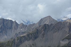
Steering tip
| Steering tip | ||
|---|---|---|
|
Lenkspitze, seen from the Rotenmannspitze |
||
| height | 3105 m above sea level A. | |
| location | Tyrol , Austria and South Tyrol , Italy | |
| Mountains | Prettaukamm , Venediger Group | |
| Dominance | 2.4 km → Spoon Point | |
| Notch height | 277 m ↓ Merbjoch | |
| Coordinates | 47 ° 0 '57 " N , 12 ° 7' 52" E | |
|
|
||
| Normal way | From the Arvental over the southwest ridge (not difficult) | |
The Lenkspitze , also Lengspitze , is 3105 m above sea level. A. high mountain peaks of the Prettaukamm in the Venediger group . The summit is on the Italian-Austrian border and was first climbed by miners. Artur Langbein made the first tourist ascent on August 26, 1903.
location
The Lenkspitze lies on the border between the South Tyrolean municipality of Prettau in the northwest and the East Tyrolean municipality of St. Jakob in Defereggen ( Lienz district ) in the southeast. In relation to the Prettaukamm, the Lenkspitze is located in the southwest. To the northeast, the Merbjoch ( 2832 m above sea level ) separates the Lenkspitze from the Merbspitze ( 3090 m above sea level ), to the southwest the Arventalscharte ( 2917 m above sea level ) marks the transition to the Arventalspitze ( 3083 m above sea level ). . The Lenkspitze consists of the main or north-east summit and the south-west summit ( 3090 m above sea level ). The southeast side of the Lenkspitze drops to the Arvental with the Arventalbach , the northwest side to the Alprechbachtal, a side valley of the Ahrntal . The mountain flanks of the Lenkspitze are protected by the Hohe Tauern National Park and the Rieserferner-Ahrn Nature Park .
Promotion opportunities
The normal route to the Lenkspitze starts at the Alpengasthaus Oberhaus and then runs first on the Almstraße to the Jagdhausalm and then to the Arventalalm. After a further section along the Arvental stream , the ascent takes place over the east-facing grass and fine rubble slopes to below the southwest ridge, where a rubble channel enables the ridge to enter. The final ascent takes place over the southwest ridge.
Individual evidence
- ↑ Clem Clements, Jonathan de Ferranti, Eberhard Jurgalski , Mark Trengove: The 3000 m SUMMITS of AUSTRIA - 242 peaks with at least 150 m of prominence , October 2011, p. 14.
- ↑ Alternative spelling according to Zloebl
- ↑ Federal Office for Metrology and Surveying Austria: Lenkspitze on the Austrian Map online (Austrian map 1: 50,000) .
literature
- Georg Zlöbl: The three thousand meter peaks of East Tyrol in the Hohe Tauern National Park . Verlag Grafik Zloebl, Lienz-Tristach 2007, ISBN 3-200-00428-2 .
- Willi End : Alpine Club Leader Venediger Group . Bergverlag Rudolf Rother ; 5th edition 2006, ISBN 3-7633-1242-0 .

