
Hohe Weg lighthouse
| Hohe Weg lighthouse | ||
|---|---|---|
 |
||
| Place: | Between Mellum and Butjadingen | |
| Location: | Outer Weser | |
| Geographical location: | 53 ° 42 '44.4 " N , 8 ° 14' 35.7" E | |
| Height of tower base: | 36 m above sea level NN | |
|
||
| Identifier : | F. WRG | |
| Scope knows: | 19.5 nm (36.1 km ) | |
| Scope green: | 16.2 nm (30 km ) | |
| Scope red: | 15 nm (27.8 km ) | |
| Optics: | Belt optics | |
| Function: | Beacon for the Hohewegrinne, orientation light, antenna carrier for a station of the land radar chain Outer Weser | |
| Construction time: | 1854 to 1856 | |
| Operating time: | since 1856 | |

The 36 meter high lighthouse Hohe Weg is the oldest fixed beacon and one of the most important navigational aids on the western edge of the outer Weser fairway . It is located 25 kilometers northwest of Bremerhaven and three kilometers east of the bird island Mellum on the edge of the Wadden Sea on the sandbank of the same name Hohe Weg off the coast of Butjadden . At high tide, the lighthouse is completely surrounded by water and at low tide, the Hohe Weg sandbank dries out. The octagonal tower made of hard fired bricks consists of a foundation in pile construction, a brick foot, two steel gallery corridors, a lantern made of steel and painted in green, and is clad with red painted aluminum plates. In the tower there is a cistern , storage rooms and several rooms for up to four lighthouse keepers who performed their duties on the tower until 1973. Due to the location, these rooms can be used by mudflat hikers in need.
history
The history of the navigation marks on the Hohe Weg sandbank goes back to 1757. A tower-like navigation mark is already drawn there on a map of the Weser estuary from that year. In 1783, with the approval of the Duchy of Oldenburg , which claimed the mouth of the Weser, a new wooden beacon was erected with the "Bremen beacon" . Due to the steadily growing shipping traffic, plans for the construction of a lighthouse began in 1824. During this time, the Hanseatic City of Bremen laid out a lightship for safety .
"Let the seafarers know that instead of the beacon that stood at the outflow of the Weser on Schmidts-Steert, but burnt down, and then erected in the same place but driven out by storm, now on the high way, a quarter mile more." south-east, a new beacon has been built, and that, from the seventh black or mellum bin, which is marked with an F, the new beacon is located south to the east, one third east, with one and three quarters of a line misdirection "

Passport map of the Weser estuary from 1757 with the route from Helgoland to Wangerooge

Bremer Baake in 1854

Construction phase 1855/56 with half-built lighthouse and baake with living rooms


With the start of steam navigation on the Outer Weser to the Bremerhaven harbor in 1840, the requirements for the fairway designation changed fundamentally. The "Bremer Baake", the fairway buoys laid out up until then and the lightship lying on the sandbank Hohe Weg no longer met the safety requirements of shipping. For this reason, the city of Bremen was ready to replace the two shipping signs with a fixed fire in the form of a lighthouse, which results in significantly lower operating costs than a lightship.
Jacobus Johannes van Ronzelen , Bremerhaven's first master builder and port construction director, was commissioned to build the lighthouse in 1854. From September 23 to October 4, 1854, he began the preliminary examinations. At the time, the construction was a great challenge, because the foundations could only be worked on at low tide and all the building materials and the accommodation of the workers commissioned with the construction had to be stored on 120 piles, each 4.5 meters deep into the tidal flats and be erected. During the construction period, the quarters for up to 70 construction workers were built around the neighboring Baake in Bremen. The construction time was a total of 15 months, so that the tower could begin its service on December 1, 1856. From 1858 the telegraph service began on the tower. In 1893 a jetty was built on the south-western side and a wind indicator (semaphore) that can be operated with lines from the tower. The semaphore on the jetty showed the passing ships the current wind direction and strength on Borkum and Helgoland and was set manually based on the data received via the telegraph. Today the semaphore is restored in Bremerhaven. The tower's first source of light was an oil lamp in a fresnel belt lens .
In the course of setting up the land radar chain outside Weser to optimize security, the tower was equipped with a new lantern housing, a radar system and directional antennas in 1960 and 1961, which were modernized in 1984. During the necessary renovations, the old, 2.4 m high belt look was replaced by a smaller one. The old optics, which was operated with a petroleum incandescent light until 1941, is now exhibited in the German Maritime Museum in Bremerhaven. In 1973 the lighthouse was the last active beacon to be fully automated and the lighthouse keepers withdrawn. Since then, the tower has been remotely monitored from Bremerhaven. In 1996 the tower was given an octagonal aluminum cladding made of red painted elements. At the beginning of the 21st century , the tower received new lighting equipment with a 4-way lamp changer and halogen bulbs with 1000 watts and a luminosity of 126,000 cd .
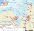
Location of the Hohe Weg sandbank in the Outer Weser

Radar chain Weser with the radar station Hohe Weg

The eponymous sandbank Hohe Weg ...

... can be seen from the air


semaphore

Semaphore ( gr. Semaphore ) were used in 1873 at prominent points on the coast of the German Reich as an optical wind indicator for shipping. The 19.3 m high semaphore of the Hohe Weg lighthouse was erected in 1893 as a signal structure on the tower's landing stage. Before the introduction of electronic communication, it was an important means of information. The semaphore shows the wind direction on Borkum (B) and Helgoland (H) with two pointers, each 4.5 meters long. Six pointers, each 1.5 meters long, show wind forces one to twelve like a form signal in rail traffic . One pointer stands for two wind speeds. In 1972 the semaphore was shut down due to heavy rust; In 1976 it was dismantled. Some parts were stored in the German Maritime Museum in Bremerhaven. The city of Bremerhaven had the semaphore for the windjammer meeting “ Sail ” reconstructed in 2005 on the initiative of the Shipping History Society of Bremerhaven and the Bremerhaven Development Company using the original parts. Since then, it has stood at the Bremerhaven north pier at the entrance to the New Harbor and takes over its function of displaying wind data. The data for display are sent free of charge by the German Weather Service every two hours and are visually displayed. The data is transferred to the individual pointers using gear motors. A comparable semaphore is in the port of Cuxhaven .
Others
On August 10, 2006, on the occasion of the 150th anniversary, a motif of the tower was published for the 55-cent special postage stamp as part of the series " Lighthouses " by Deutsche Post AG .
See also
Web links
- Hoheweg . Bremerhaven Waterways and Shipping Authority. May 5, 2009. Retrieved March 6, 2010.
- C. Mauel and F. Hermann: Modernization of the beacon equipment of the Hohe Weg lighthouse (WSA Bremerhaven) . WSV specialist office for traffic engineering. May 17, 2009. Retrieved March 6, 2010.
- Matthias Hünsch, Birgit Toussaint, Frank Toussaint: Beacon Hohe Weg, data on the beacon . July 7, 2009. Retrieved March 6, 2010.
- 150 years of the Hohe Weg lighthouse: history and technology WSD-Nordwest . (see page 96..120)
literature
- Jacobus Johannes van Ronzelen : Description of the construction of the Bremen lighthouse at the place of the Bremerbaake in the Weser estuary. Bremerhaven 1857.
- Rolf Seedorf: Between the Weser and Ems - 150 years of the Hohe Weg lighthouse . Position: Outer Weser, 53 ° 42.7 'N, 08 ° 14.6' E (WGS 84). Ed .: Waterways and Shipping Directorate Northwest. Aurich 2006, p. 96–101 ( wsd-nordwest.wsv.de [PDF; 420 kB ]).
- Gerhard Schiwy: Between the Weser and Ems - radar on the Hohe Weg lighthouse . Ed .: Waterways and Shipping Directorate Northwest. Aurich 2006, p. 108–114 ( wsd-nordwest.wsv.de [PDF; 948 kB ]).
- Birgit Toussaint, Frank Toussaint, Matthias Hünsch: Lighthouses on the German North Sea coast . Edition Maritim, Bielefeld 2009, ISBN 978-3-89225-606-9 .
- Birgit Toussaint, Frank Toussaint, Matthias Hünsch: German beacons: All the lighthouses on our coasts . Edition Maritim, Bielefeld 2005, ISBN 3-89225-530-X .
- Friedrich-Karl Zemke: German lighthouses then and now . 3. Edition. Koehlers Verlagsgesellschaft mbH, Hamburg 2000, ISBN 3-7822-0769-6 .
Individual references and references
- ^ Arend Wilhelm Lang: History of the sea mark system . Development, establishment and administration of the navigation system on the German North Sea coast until the middle of the 19th century. Ed .: Federal Ministry of Transport. Bonn 1965, staff of the lighthouses and lightships, p. 10 .
- ↑ a b Hoheweg . Bremerhaven Waterways and Shipping Authority. May 5, 2009. Archived from the original on January 8, 2014. Info: The archive link was inserted automatically and has not yet been checked. Please check the original and archive link according to the instructions and then remove this notice. Retrieved March 6, 2010.
- ^ Otto Franzius: 100 Years of the Norderney Lighthouse 1874–1974 . Ed .: Wasser- und Schiffahrtsamt Emden [WSA]. Self-published, 1974, p. 5 .
- ↑ C. Mauel, F. Hermann: Modernization of the beacon equipment of the Hohe Weg lighthouse (WSA Bremerhaven) . WSV specialist office for traffic engineering. May 17, 2009. Retrieved March 6, 2010.
- ↑ semaphore . City of Bremerhaven. Retrieved March 6, 2010.
- ↑ Hinrich Gravert: Reconstruction of the semaphore from the lighthouse Hohe Weg . Shipping History Society Bremerhaven e. V .. July 17, 2008. Archived from the original on May 22, 2009. Info: The archive link was automatically inserted and not yet checked. Please check the original and archive link according to the instructions and then remove this notice. Retrieved March 6, 2010.
- ↑ Impressions from the port of Cuxhaven . Thomas Saevert. July 19, 2007. Archived from the original on February 24, 2013. Info: The archive link was inserted automatically and has not yet been checked. Please check the original and archive link according to the instructions and then remove this notice. Retrieved March 6, 2010.