
Small fort Pohl
| Small fort Pohl | |
|---|---|
| Alternative name | Small fort "On the corner near Pohl" |
| limes | ORL - ( RLK ) |
| Route (RLK) |
Upper German Limes , route 2 (Lahn-Aar) |
| Type | Small fort |
| unit | unknown vexillatio |
| size | 43 m × 34 m |
| Construction | Wood earth |
| State of preservation | Invisible, partly overbuilt ground monument (reconstruction opened in 2011) |
| place | Pohl |
| Geographical location | 50 ° 15 '4.2 " N , 7 ° 52' 4.9" E |
| height | 337 m above sea level NHN |
| Previous | ORL 5: Fort Hunzel (west) |
| Subsequently | Small fort Pfarrhofen (southeast) |

The small fort Pohl (in older literature also small fort "On the corner near Pohl" ) was a Roman border fort of the Upper German Limes , which has had the status of a UNESCO World Heritage Site since 2005 . The former military camp is now a ground monument on the outskirts of Pohl ( Verbandsgemeinde Bad Ems-Nassau ), a local community in the Rhineland-Palatinate Rhein-Lahn district .
location

The small fort Pohl was located at around 337 meters above sea level at an exposed point on the Limes, at which it abruptly changed its direction from east to north-east by around 75 degrees , and then continued on its way in a south-easterly direction. The archaeologist and officer Karl August von Cohausen noticed this militarily important position. Here also a road - coming from the Rhine valley in the west - met an old long-distance connection that led from the lower Lahn valley to the Taunus. The garrison of the small garrison was responsible for securing this geographically significant point, the resulting Limes crossing and the "wedge" formed by the change in the course of the border.
In today's townscape, the (no longer visible and partly overbuilt) soil monument is located on the northeastern edge of the municipality, in the area where Schulstrasse leaves the town in the direction of Lollschied .
Findings
The archaeological excavations repeatedly carried out by the Imperial Limes Commission , in particular from 1897 to 1900 under the direction of Robert Bodewig and in 1903 under Ernst Fabricius , who ultimately discovered the fort, only led to unsatisfactory results. Accordingly, the small fortification of Pohl was a rectangular wood-earth structure with sides of around 43 × 34 m. The fence consisted of an earth wall covered with palisades and fortified with turf. On the crown of the rampart, behind the palisade, was a narrow battlement. A simple pointed ditch up to 2.35 m deep served as an obstacle.
The interior construction was probably made of wood. The traces of these wooden structures had already been lost or could not yet be recorded with the excavation methods of the time. It was probably a U-shaped system with two barracks for the crew attached to the rear of a representative main building (staff building, commandant's apartment) facing the front gate. Stone building fragments in the north corner of the camp, which the commission had encountered, are interpreted today as the remains of a younger watchtower belonging to the tower site Wp 2/23 (see below).
The crew of the camp consisted of a vexillatio whose name was not known , the unit of a larger auxiliary force or legion assigned here . Nothing can be seen of the original fort in the largely modernly built-up area. The full and authentic reconstruction (see below) can be found elsewhere.
"Limeskastell Pohl" project
In June 2007 the Förderkreis Limeskastell Pohl e. V. founded. It now has over 270 members (as of September 2017) and has set itself the goal of “initiating and promoting projects, campaigns, events and publications relating to the UNESCO World Heritage Site Limes in the Nassau, Nastätten and Katzenelnbogen” area . In this context, the Limes Fort Pohl was rebuilt - somewhat offset from its historical location - as a speculative reconstruction based on the findings plans. A Limburg architecture firm was entrusted with the drafts. Construction began in September 2009 and was completed in May 2011. The opening took place on October 1st, 2011.

Construction work on the attempt to reconstruct the small fort Pohl in 2010
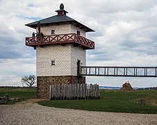
The watchtower accessible via a bridge
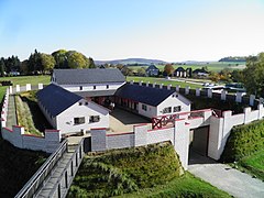
The small fort from the watchtower

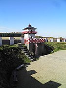
Wall system with battlement from the inside

Wall system from the outside
The speculative gate system from the inside

Attempt to reconstruct a crew quarters


.jpg)
.jpg)
.jpg)
.jpg)
.jpg)
Limes course between the small forts Pohl and Pfarrhofen
The Limes runs in a large arc around the former small fort (and the current town of Pohl) and then runs in a south-easterly direction towards the small fort Pfarrhofen, partly through wooded area in which it is still very well preserved, partly through land that is used today for agriculture who can no longer perceive anything today. It rises by almost 40 meters.
| ORL | Name / place | Description / condition |
|---|---|---|
| Wp 2/23 | Suspected, but not proven, tower site in the immediate vicinity of the small fort Pohl. | |
| KK | Small fort Pohl | see above |
| Wp 2/24 | Due to the distance between Wp 2/23 and Wp 2/25 as well as the topographical conditions assumed, but not archaeologically proven, tower site. | |
| Wp 2/25 | "In the Pohl forest" |
  The square stone tower had a side length of approximately 5.50 m and a wall thickness of only 80 cm. At a distance of about two meters, the tower was surrounded by an almost square, shallow ditch, which in places was filled with large amounts of fire rubble, smelter clay and slabs of slate. In the western corner of the tower was a 75 cm wide, 1.40 m long and 2.40 m deep pit of unknown destination. It was filled with rubble from the tower. Immediately in front of the stone tower, the Limes wall and large moat were interrupted. The foundation walls of the stone tower have been preserved. The two wooden towers were on a circular platform with a diameter of around 8.80 m. The posts of the inner tower indicated a square floor plan with a side length of 2.30 m, those of the outer tower indicated a side length of around five meters. The wooden towers were surrounded by moats. The inner ring trench had a diameter of about 11.40 m (floor-floor), the outer one of 19.5 m. Both trenches showed an interruption on the northeast side. The inner ditch was partially filled with large amounts of fire rubble, ceramic shards and charcoal, and the ground was reddish bricked by the action of heat. The Limes palisade passed the wooden tower at a distance of around 15 m. It cuts the south-western slope of a prehistoric burial mound. |
| Wp 2/26 | "Near Obertiefenbach" |
 The stone tower was a square structure with a side length of about 5.50 m. According to the findings, the tower had been destroyed by fire. |
| Wp 2/27 | "In the cabbage forest" |
 The rectangular stone tower had sides of 5.65 m by 6.28 m, the thickness of its walls was 75 cm. The tower was surrounded by a shallow, 60 cm wide ditch, which - except for the rounded corners - also has a rectangular shape. The distance between the tower and the moat was between 2.65 m and 3.20 m. The Limeswall and the great moat, but not the palisade moat, were interrupted directly in front of the stone tower.  The wooden tower site, which had two construction phases, was immediately south of the stone tower. The wooden towers were on a circular platform about 8.50 m in diameter. The posts of the inner wooden tower indicated a rectangular structure measuring 2.35 m by 2.50 m on a side. The outer wooden tower had a floor plan with a side length of about 4.90 m. Both towers were surrounded by moats. The inner ring trench had a diameter of 11.50 m to 12.00 m. It was about three meters wide and had a depth between 1.55 m and 1.90 m. The outer moat was wider but less deep. It had a diameter of around 19.50 m (from trench bottom to trench bottom). Both trenches were interrupted on the east side. |
| Wp 2/27 to 2/28 |
 |
|
| Wp 2/28 | "Am Oberen Pfarrhofen" |
 The stone tower was a square structure with a side length of 5.33 m. Its wall thickness was 80 cm. The bottom of the Limes trench was about 23 m from the tower. It was interrupted in this area in order to allow two hollow paths embroidered with stones to cross the Limes. A wooden tower could not be identified at this tower location. |
| KK | Pfarrhofen small fort | see main article small fort Pfarrhofen |
Monument protection
The small fort Pohl and the aforementioned ground monuments have been part of the UNESCO World Heritage as a section of the Upper German-Rhaetian Limes since 2005 . In addition, the facilities are cultural monuments according to the Monument Protection and Conservation Act (DSchG) of the state of Rhineland-Palatinate. Investigations and targeted collection of finds are subject to approval, and accidental finds are reported to the monument authorities.
See also
literature
- Dietwulf Baatz : The Roman Limes. Archaeological excursions between the Rhine and the Danube. 4th edition. Gebr. Mann, Berlin 2000, ISBN 3-7861-2347-0 .
- Jens Dolata: Replicas of the small fort and watchtower in Pohl . In: The Limes. Newsletter of the German Limes Commission 1/2012, pp. 18-22. (PDF; 2.7 MB) , (accessed on September 6, 2012)
- Ernst Fabricius , Felix Hettner , Oscar von Sarwey (ed.): The Upper Germanic-Raetian Limes of the Roemerreich . Section A, Volume 1: Lines 1 and 2 (1936)
- Christian Fleer: Typification and function of the small buildings on the Limes. In: E. Schallmayer (Ed.): Limes Imperii Romani. Contributions to the specialist colloquium “Limes World Heritage Site” in November 2001 in Lich-Arnsburg. Bad Homburg vd H. 2004, ISBN 3-931267-05-9 , pp. 75-92 (Saalburg-Schriften 6).
- Cliff Alexander Jost: The Roman Limes in Rhineland-Palatinate . State Office for Monument Preservation Rhineland-Palatinate , Koblenz 2003 (Archeology on the Middle Rhine and Moselle, Volume 14), ISBN 3-929645-07-6 .
- Margot Klee: The Limes between Rhine and Main. Theiss, Stuttgart 1989, ISBN 3-8062-0276-1 .
- Margot Klee: Limes. Course 2, SS 2 / 1–2 / 34 . In: Heinz Cüppers : The Romans in Rhineland-Palatinate. Licensed edition of the 1990 edition, Nikol, Hamburg 2002, ISBN 3-933203-60-0 , pp. 449-450.
Web links
- Limeskastell Pohl on the website of the support group Limeskastell Pohl e. V.
- The Limes near Pohl on the official website of the municipality of Pohl
- The Limes near Pfarrhofen and Pohl on the official website of the community of Bettendorf
- Advertising film for the “Open-Air Museum Limeskastell Pohl” by FS Medien, Friedhelm Schierle on You Tube , accessed on June 25, 2014
Remarks
- ^ Karl August von Cohausen: The Roman border wall in Germany. Military and technical description of the same . Kreidel, Wiesbaden 1884, p. 214.
- ↑ According to the information from the Förderkreis Limeskastell Pohl e. V.
- ↑ Self-presentation of the association's goals on the website of the Förderkreis Limeskastell Pohl e. V.
- ↑ ORL = numbering of the Limes structures according to the publication of the Reich Limes Commission on the O bergermanisch- R ätischen- L imes
- ↑ Wp = W oh p east, watch tower. The number before the slash denotes the Limes section, the number after the slash denotes the respective watchtower.
- ↑ Wp 2/23 at approximately 50 ° 15 '5.5 " N , 7 ° 52' 4" O .
- ↑ KK = unnumbered K linseed K astell
- ↑ Wp 2/24 at approximately 50 ° 14 '56 " N , 7 ° 52' 17.04" O .
- ↑ Wp 2/25 at 50 ° 14 '38.3 " N , 7 ° 52' 34.16" O .
- ↑ Wp 2/25 at 50 ° 14 '38.58 " N , 7 ° 52' 33.7" O .
- ↑ Wp 2/26 at approximately 50 ° 14 '26.37 " N , 7 ° 53' 2.9" O .
- ↑ Since the agriculturally used areas of the site had already been cultivated, a large-scale investigation was not carried out.
- ↑ Wp 2/27 at 50 ° 14 '2.04 " N , 7 ° 53' 20.98" O .
- ↑ Wp 2/27 at 50 ° 14 '1.59 " N , 7 ° 53' 21.14" O .
- ↑ Wp 2/28 at 50 ° 13 '39.88 " N , 7 ° 53' 31.89" O .
- ↑ DschG or DSchPflG RP
