
Holzhausen fort
| Holzhausen fort | |
|---|---|
| limes | ORL 6 ( RLK ) |
| Route (RLK) |
Upper German Limes , route 2 (Lahn-Aar) / (western Taunus route) |
| Dating (occupancy) | Commodus until the middle of the 3rd century |
| Type | Cohort fort |
| unit | Cohors II Treverorum |
| size | 135 m × 105 m |
| Construction | stone |
| State of preservation | very well preserved ruin |
| place | Holzhausen an der Haide |
| Geographical location | 50 ° 12 '53.6 " N , 7 ° 56' 51.8" E |
| height | 495 m above sea level NHN |
| Previous | Pfarrhofen small fort |
| Subsequently | Small fort "Auf dem Dörsterberg" |
The Holzhausen fort was a Roman border fort in the Upper German Limes , which has been a UNESCO World Heritage Site since 2005 . The former cohort fort is now located as a ground monument in the woods of Holzhausen an der Haide ( Verbandsgemeinde Nast topeten ), a local community in the Rhineland-Palatinate Rhein-Lahn district . It is one of the best preserved Limes forts in Germany.
location


In today's topography, the soil monument is located north of the federal highway 260 , the so-called "Bäderstraße Taunus", between Holzhausen an der Haide (Rhineland-Palatinate) and Laufenselden (Hesse) in an extensive forest area. There it is at an average of 495 meters above sea level on the north-western slope of the Grauer Kopf , at 543.4 m above sea level. NN second highest mountain in the western Hintertaunus .
In the course of the Limes, the Holzhausen fortification is the southernmost and last fort in the state of Rhineland-Palatinate. The border with Hesse is only a good 120 m northeast. The next watchtower (Wp 2/35) is already on Hessian territory.
Research history
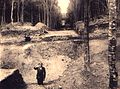
Thanks to their secluded location, the ruins of the fort remained untouched for a long time. It was only in connection with the construction of the so-called Bäderstraße at the beginning of the 19th century that extensive damage occurred, as the fort walls were used as a cheap quarry for the construction of the Chaussee . A first, more detailed description of the fort site appeared in the Nassau Annals in 1859 . More extensive archaeological investigations were then carried out by Karl August von Cohausen in 1874 and 1882, before extensive excavations were carried out between 1897 and 1903 by the Reichs-Limeskommission (RLK) under the direction of the route commissioner Ludwig Pallat . The last scientific excavations for the time being were carried out by Karl Nass in 1932.
- Recordings from the time of the so-called "Reich excavations" by the Reich Limes Commission (1897–1903)

Porta Praetoria, interior view

Porta Decumana, interior view
View from Porta Decumana to Porta Praetoria

View from the Porta Principalis Dextra to the Porta Principalis Sinistra


Findings
Fort


The Holzhausen fort is one of the smallest garrisons in the Upper German Limes. With its dimensions of 135.4 m by 105.6 m, it covered an area of just over 1.4 hectares. With its praetorial front , it was - in contrast to the standard - not facing the Limes, which passed the fort in the north-west at a distance of 70 m to 100 m, but facing the northeast. This circumstance may be due to the topographical conditions that made such an alignment necessary on the slope of the "Gray Head", if one wanted to avoid too steep a slope within the fort area. Even so, the height difference between the Porta principalis dextra (right side gate) and the Porta principalis sinistra (left side gate) is still considerable at more than nine meters. The extension of Via praetoria led to a Limes crossing about 350 m away.
The defensive wall was 1.50 m thick, the foundation was 90 cm deep and 1.50 to 1.65 m wide. It was made with the locally occurring greywacke on the outside in regular, almost horizontal masonry, on the inside the stones were set less carefully and more irregularly using large amounts of lime mortar. On the outside, the fort wall was plastered in yellowish-white and provided with irregular, red false joints. A pointed ditch ran in front of the wall, which only exposed in front of the Porta principalis sinistra facing the Limes . It had a width of 5.50 m to 6.00 m and reached a maximum depth of 2.00 m (next to the Porta decumana ) with an average of 1.40 m to 1.60 m. The trench was separated from the wall by a bench of different widths, which differed between 1.50 m and 2.00 m along the wall and 1.00 m and 3.50 m at the gates. On the inside of the camp there was an earth wall 9.50 m to 10.50 m wide at its base, which supported the battlement.
The fence was provided with gates on all four sides. The gate on the Praetorial Front was the largest with a width of 8.40 m. It was designed as a double gate with a central pillar. According to the excavation findings, there was probably a bridge over the uninterrupted ditch in front of this gate. The rounded corners of the defensive wall were studded with towers. In the towers there were (in three verifiably reconstructed in the north corner) fixtures that were addressed as constructions for - possibly rotating - gun superstructures.
Mainly parts of the Principia (staff building) could be exposed from the interior . Particularly in the rear part of the Principia , the foundation walls of the flag sanctuary ( Sacellum or Aedes ), designed as an apse and with no basement, were preserved up to a meter in the ascending part. Of the service and assembly rooms to the right and left of the flag shrine, at least one (the one to the northwest) had a hypocaust . The other internal structures were probably made of wood or half-timbered and could not be recorded with the excavation methods at the time of the Imperial Limes Commission. Only during the 1932 excavation was it possible to prove three other buildings in the northwest of the Principia , one of which was interpreted as a crew barracks.

Profiles of the enclosure

Floor plans of the gate systems and profiles of the weir trench

Floor plan details of the corner towers

Various building details


Fort bath

The thermal baths could be located northwest of the fort, between it and the Limes, not far from the source of the Hasenbach, which probably supplied the thermal baths with water. They were examined by Cohausen in 1882 and later by the commission, but in both cases could not be systematically excavated due to a lack of the necessary funds. While the RLK only examined the course of the outer wall facing the fort, Cohausen was able to examine at least part of the building complex more closely. The architectural form with apses as well as the high number of Tegulae (bricks) found suggest that this part of the building could be the caldarium (warm bath) and the tepidarium (leaf bath) .
Vicus
Also for financial reasons, the vicus , the civilian settlement to be found in every major Roman garrison, could not be examined in more detail either during the 1882 campaign or during the imperial excavations. At least it was possible to find traces of non-military settlement in front of the Porta praetoria , in front of the Porta principalis dextra and in front of the Porta decumana . The deformations of the terrain in the forest speak in favor of further findings that are to be expected but have not yet been excavated .
Dating and occupancy

According to the previous view, the Holzhausen fort was built under Commodus , probably at the same time as the Niederbieber fort around 185/190. The coin finds do not support this initial dating, as its initial maximum is only around 220 AD. Coins of Septimius Severus are severely underrepresented. The latest dating approach is the year 213 AD due to the honorary inscription for Emperor Caracalla .
It was documented by the Cohors II Treverorum ("2nd cohort of Treverians "), a sister unit of the Cohors I Treverorum stationed in Fort Zugmantel , which is attested by numerous inscriptions. Over time, this pure infantry unit took on various surnames. At the beginning of the third century it was named after the reigning Emperor Caracalla Cohors II Antoniniana Treverorum , but a few years later it changed its name to Cohors II Severiana Treverorum . This name also referred to the reigning Princeps, this time to Severus Alexander . The fort existed until the Limes was abandoned in 259/260.
Limes course between the Holzhausen fort and the small fort on the Dörsterberg
Immediately to the east of the Holzhausen fort, the Limes passes the Rhineland-Palatinate-Hessian border. The first watchtower following in this direction, Wp 2/35, is already on Hessian territory.
A little over a kilometer, the Limes still stretches in an irregular course based on the topographical conditions in an easterly direction, and then turns in a large arc to the south in the area of the watchtower Wp 2/36. It retains the southern course taken there up to Wp 2/39, where it finally takes a south-easterly direction leading to the small fort on the Dörsterberg. In total, it drops by around 50 meters in altitude on this path. The route mainly leads through densely forested area, only in the area of Wp 2/41 the agriculturally used areas southwest of the town of Laufenselden are affected.
| ORL | Name / place | Description / condition |
|---|---|---|
| ORL 6 | Holzhausen fort | see above |
| Wp 2/35 | "East of Holzhausen Castle" |
|
| Wp 2/36 | "In stroke 44 of the Laufenselder forest" | The perceptible part of the tower was discovered by Ludwig Pallat in 1896. Only a stone tower could be found, traces of previous wood accessories were not found. The tower had a square footprint of 4.80 meters on each side and was oriented towards the Limes, which ran past 16.20 meters to the northeast. |
| Wp 2/37 | "In stroke 40 of the Laufenselder forest" |
  The stone tower had an almost square floor plan with the aspect ratios of 4.15 / 4.21 to 4.12 / 4.20 meters. The thickness of the walls was only 0.60 to 0.65 meters. There were large post holes in the four corners, some of which were deeper than the lower edge of the foundation. The tower faced east, facing the Limes. The distance between the tower and the Limes palisade was around 31 meters. |
| Wp 2/38 | "Am Nastätter Weg" |
 The tower was about 25 meters away from the palisade of the Limes, which passed it to the east and about 80 m north of a valley that began at its beginning to the south and southeast and then to the east. Presumably the task of the watchtower crew was to monitor this valley, which stretched far across the Limes into the non-Roman-occupied part of Germania. |
| Wp 2/39 | "In stroke 36 of the Laufenselder forest" |
 The stone tower had a square floor plan with sides of 4.90 meters, its wall thickness was approximately 0.80 meters. It was located on a slope that sloped slightly to the east and faced the Limes, the palisade of which passed the tower 50.50 meters east-northeast. |
| Wp 2/40 | "Am Gronauer Weg" |
 The stone tower was about 25 m south-southwest of the Limes Palisade. The size of the tower and the dimensions of the masonry could no longer be determined. |
| Wp 2/41 | "Am Schönauer Weg" |
 The tower was in an exposed position from which large parts of the area could be seen. The distance to the Limes palisade passing in a north-northeast direction was around 20 m. |
| Wp 2/42 | "In the Fuchshohl" | Still visible, the tower part of a stone tower examined by Pallat in 1897. The distance to the Limes palisade passing in the NNE was 13 meters. The tower probably served - together with the small fortress Dörsterberg on the opposite side of the valley - to monitor the Dörsbach valley, which ran in a north-south direction. |
| KK | On the Dörsterberg | see main article small fort on the Dörsterberg |
Others
In the area of the fort there is an occurrence of the small evergreen . As with numerous other Roman fort buildings, it can be traced back to Roman times of planting.
Monument protection
The Holzhausen Fort and the aforementioned ground monuments have been part of the UNESCO World Heritage as a section of the Upper Germanic-Rhaetian Limes since 2005 . In addition, the facilities are cultural monuments according to the Monument Protection and Conservation Act (DSchG) of the state of Rhineland-Palatinate. Investigations and targeted collection of finds are subject to approval, and accidental finds are reported to the monument authorities.
- Find material from the time of the so-called "Reich excavations" by the Reich Limes Commission (1897-1903)

Bronze finds

Building inscription of the Porta Principalis Sinistra in honor of Caracalla
(see drawing above)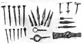
Iron finds

Stone finds


See also
literature
- Dietwulf Baatz : The Roman Limes. Archaeological excursions between the Rhine and the Danube. 4th edition, Mann, Berlin 2000, ISBN 3-7861-2347-0 , p. 112 ff.
- Dietwulf Baatz: Limes. Western Taunus route (Rheingau-Taunus district). Section 2, Wp 35-55 and Section 3. Wp 1-35 . In: Dietwulf Baatz and Fritz-Rudolf Herrmann: The Romans in Hessen. Licensed edition of the 1982 edition, Nikol, Hamburg 2002, ISBN 3-933203-58-9 , p. 375 ff.
- Ernst Fabricius, Felix Hettner, Oscar von Sarwey (ed.): The Upper Germanic-Raetian Limes of the Roemerreich. Department A, Volume 1: The routes 1 and 2 (1936), p. 71ff. and panel 10, Figs. 2 to 6
- Cliff Alexander Jost: The Roman Limes in Rhineland-Palatinate . State Office for Monument Preservation Rhineland-Palatinate , Koblenz 2003, ISBN 3-929645-07-6 , (= Archeology on the Middle Rhine and Moselle 14), p. 202 ff.
- Margot Klee : The Roman Limes in Hessen. History and sites of the UNESCO World Heritage. Verlag Friedrich Pustet, Regensburg 2009, ISBN 978-3-7917-2232-0 , pp. 67-73
- Margot Klee: Holzhausen adH cohort fort . In: Heinz Cüppers : The Romans in Rhineland-Palatinate. Licensed edition, Nikol, Hamburg 2002, ISBN 3-933203-60-0 , p. 392 ff.
- Margot Klee: The Limes between Rhine and Main. From the beginning of the Upper German Limes near Rheinbrohl to the Main near Grosskrotzenburg. Theiss, Stuttgart 1989, ISBN 3-8062-0276-1 , p. 59 ff.
- Ferdinand Kutsch : On the history of the Limes at Kastell Holzhausen. In: Nassauische Annalen 54, 1934.
- Ludwig Pallat in the series Der Upper Germanic-Raetian Limes of the Roemerreiches (Eds. Ernst Fabricius , Felix Hettner , Oscar von Sarwey ): Department B, Volume 1, Fort No. 6: The Holzhausen Fort (1904)
- Barbara Pferdehirt : The ceramics of the Holzhausen fort . Mann, Berlin 1976. ISBN 3-7861-1070-0 (= Limes research 16).
- Marcus Reuter : Cohortes Treverorum on the Taunus Limes? For the occupation of the fort Zugmantel and Holzhausen. In: Andreas Thiel (ed.): New research on the Limes . 4th specialist colloquium of the German Limes Commission 27./28. February 2007 in Osterburken. Theiss, Stuttgart 2008, ISBN 978-3-8062-2251-7 , (= contributions to the Limes World Heritage Site 3), pp. 83–91
Web links
- Kastell Holzhausen on the website of the Ministry of Education, Science, Youth and Culture Rhineland-Palatinate
- Kastell Holzhausen on the website of the German Limes Commission
Remarks
- ^ DW Wagner: The Pfahlgraben fort near Holzhausen . In: Nassauische Annalen 6 (1859/60), pp. 203-210.
- ^ Karl August von Cohausen: The Roman border wall in Germany. Military and technical description of the same . Kreidel, Wiesbaden 1884, p. 200 ff.
- ^ Karl Nass: Holzhausen Castle. (Excavated from July 15 to November 30, 1932) . In: Nassauische Annalen 54, 1934, pp. 233-269.
- ↑ While the Reichs-Limeskommission assumed the topographical conditions as the reason for the alignment of the fort, Dietwulf Baatz sees: Limes. Western Taunus route (Rheingau-Taunus district). Section 2, Wp 35-55 and Section 3. Wp 1-35 . In: Dietwulf Baatz and Fritz-Rudolf Herrmann: The Romans in Hessen. Licensed edition of the 1982 edition, Nikol, Hamburg 2002, ISBN 3-933203-58-9 , p. 359, the Limes crossing as the cause.
- ↑ Ludwig Pallat in the series Der Upper Germanic-Raetian Limes des Roemerreiches (Eds. Ernst Fabricius, Felix Hettner, Oscar von Sarwey): Department B, Volume 1, Fort No. 6: Das Kastell Holzhausen (1904), p. 20 and Margot Klee: Holzhausen adH cohort fort . In: Heinz Cüppers: The Romans in Rhineland-Palatinate. Licensed edition, Nikol, Hamburg 2002, ISBN 3-933203-60-0 , p. 393.
- ↑ a b c [Imp (eratori)] Caes (ari) M (arco) A (urelo) A [ntonino pio] f [el] lici [Parth (ico)] max (imo) Brit (annico) ma [x ( imo) Ger (manico) max (imo) p] on (tifici) m [ax (imo)] trib (unicia) pot (estate) XVI imp (eratori) III co [(n) s (uli) IIII p (atri ) p (atriae)] invictissimo Aug (usto) c [oh (ors) II A] nton [in] iana Tre (verorum) d [evo] ta ac dicat [am] a (i) [esta] ti eius = " To the emperor Caesar Marcus Aurelius Antoninus Pius, the lucky one, the greatest victor over the Parthians , the British and the Teutons , the highest priest , in the 16th year of his tribunician power , after he had been proclaimed emperor three times and consul four times , the father of the Fatherland, the most invincible Augustus of the 2nd Trever cohort, deeply devoted to his Majesty ”.
- ↑ Klaus Kortüm : On the dating of the Roman military installations in the Upper German-Raetian Limes area. In: Saalburg-Jahrbuch 49, 1998. Zabern, Mainz 1998, p. 36 f.
- ↑ a b CIL 13, 07617 .
- ↑ ORL = numbering of the Limes structures according to the publication of the Reich Limes Commission on the O bergermanisch- R ätischen- L imes
- ↑ ORL XY = consecutive numbering of the forts of the ORL.
- ↑ Wp = W oh p east, watch tower. The number before the slash denotes the Limes section, the number after the slash denotes the respective watchtower.
- ↑ Wp 2/35 at 50 ° 12 '57.18 " N , 7 ° 57' 19.83" O . Source: Entry on Limes watchtower Wp 2/35 near Heidenrod-Laufenselden in the " KuLaDig " database of the Rhineland Regional Association , accessed on July 18, 2017.
- ^ Karl August von Cohausen: The Roman border wall in Germany. Military and technical description of the same . Kreidel, Wiesbaden 1884, p. 198.
- ↑ Wp 2/36 at 50 ° 12 '53.39 " N , 7 ° 57' 53.83" O .
- ↑ Wp 2/37 at 50 ° 12 '45.9 " N , 7 ° 57' 59.04" O .
- ↑ Wp 2/38 at 50 ° 12 '34.37 " N , 7 ° 58' 2.16" O .
- ↑ Wp 2/39 at 50 ° 12 '22.58 " N , 7 ° 58' 4.44" O .
- ↑ Wp 2/40 at 50 ° 12 '12.26 " N , 7 ° 58' 23.87" O .
- ↑ Wp 2/41 at 50 ° 12 '5.9 " N , 7 ° 58' 50.73" O .
- ↑ Wp 2/42 at 50 ° 11 '55.68 " N , 7 ° 59' 22.26" O .
- ↑ KK = unnumbered K linseed K astell
- ↑ Christian Stolz (2013): Archaeological pointer plants: case studies from the Taunus and northern Schleswig-Holstein. Plants as indicators for archaeological find sites: Case studies from the Taunus Mts. and from the northern part of Schleswig-Holstein (Germany) . - Writings of the Working Group on Regional and Folklore Studies 11: 1-30
- ↑ DschG or DSchPflG RP
