
Niederbieber Castle
| Niederbieber Castle | |
|---|---|
| limes | ORL 1a ( RLK ) |
| Route (RLK) |
Upper German Limes , route 1 (Rhine-Lahn) |
| Dating (occupancy) | around 185/190 AD to possibly 260 AD |
| Type | Double fort |
| unit | a) Numerus Exploratorum Germanicianorum Divitiensium b) Numerus Brittonum |
| size | 265.25 m × 198.5 m = 5.25 ha |
| Construction | stone |
| State of preservation | mostly overbuilt; some foundation walls preserved and partially reconstructed |
| place | Neuwied - Niederbieber - Segendorf |
| Geographical location | 50 ° 28 '1.3 " N , 7 ° 28' 19" E |
| height | 75 m above sea level NHN |
| Previous | Small fort "Am Forsthofweg" (northwest) |
| Subsequently | Small fort Anhausen (east-northeast) |
| Backwards | ORL 1: Fort Heddesdorf (south; preceded Fort Niederbieber in time) |
The Niederbieber fort was a Roman border fort in the Upper German Limes , which has been a UNESCO World Heritage Site since 2005 . The former auxiliary fort , one of the largest on the Limes, is now a ground monument under a residential estate in Niederbieber , a district of the Rhineland-Palatinate city of Neuwied in the Federal Republic of Germany , that was built after 1945 . Niederbieber is one of the largest, most important and best-researched Roman military camps on the Upper German Limes. Despite the irreplaceable military and cultural historical value of this complex and its associated camp settlement, the ruthlessly driven destruction has continued until recently. In scientific circles there is therefore talk of an "immense loss" .
location

The Niederbieber fort is located topographically on a flat elevation east of an arch that the Wied forms immediately after it has left the area of the Westerwald and entered the Neuwied basin . This elevation is limited to the east and south by the Aubach .
In Roman times the fortification was located directly behind the Limes, which only passed 150 meters northeast of the camp, at a point where several paths from the northwest and north entered the Neuwied Basin. The fort crew was probably responsible for monitoring these traffic routes and the Wied valley. In addition, the teams for the watchtowers and small forts in the northernmost Limes area up to the Rheinbrohl small fort were probably assigned from here.
In today's townscape, the location of the fort is roughly described by the square formed by the streets Burgstraße, Am Limes, Melsbacher Straße and Ringmauerstraße. The Ringmauerstraße is, however, still a little way inside the camp, the Praetorial Front (front front) running parallel to it around 60 meters further south.
Research history
The first reports of ruins and finds of inscription stones in the area around the village of Niederbieber at that time date back to the 17th century, the old names of which , such as "Auf der Altenburg" and "Auf der Ringmauer", refer to the fort and in some cases still exist in the modern street names are preserved.

In the 18th century, the basis of a first collection of antiquities with finds from the fort and vicus area of Niederbieber was created in Neuwied Castle . The impetus for this was given in 1759 by the then Count Johann Friedrich Alexander . When the count asked what was known about local antiquities, the then pastor Breusing von Niederbieber reported about a palace that had stood on the Altenburg. The clergyman began digging a floor deep in the site that same year. According to his own admission, he found, among other things, a pair of scales, the copper portrait of an idol, roof tiles, coal and ashes. Obviously a number of finds were lost before they reached the count. In February 1791, at the instigation of the ancient princess Luise Wilhelmine zu Wied - who personally started the spade in Niederbieber in the summer of the same year - planned but largely undocumented excavations began . Initially with a few interruptions under the direction of the chief engineer Christian Friedrich Hoffmann and after his death in the year 1820 to 1829 by the archivist Hugo von Knopäus († 1838). During the period after 1820, the retired, antiquity-loving Hofrat Wilhelm Dorow (1790–1845) was also interested in the fort grounds. Hoffmann (1819, 1823) had already published about his excavations, Dorow published further research results and compilations from Hoffmann's estate in 1826. More reports followed. Many of the most beautiful and valuable pieces from the excavations found their way into the princely collection, which was visited by many scholars such as Goethe in 1815.
After the middle of the 19th century, apart from a few depressions in the ground that testified to stone robberies, nothing left to be seen of the fort, which was then still in the open area, apart from bricks and mortar remains. The archeology pioneer Karl August von Cohausen (1812-1894) reported in 1869 that the surrounding wall had been partially excavated, which was visible at the time, from which stone material for road construction had been removed. As the mining expert Ernst Heinrich Carl von Dechen (1800–1889) had already reported in 1864, the defensive wall was still openly visible in 1861, before its remains were excavated “as a packing area for the road from Niederbieber to Oberbieber” .
In the following decades there were always isolated investigations until the archaeological excavations were resumed in 1894 . First under the direction of the archaeologist Constantin Koenen (1854-1929), and from 1897 under that of the archaeologist and route commissioner of the Reich Limes Commission (RLK), Emil Ritterling (1861-1928). Niederbieber subsequently became one of the most important projects of the RLK. Further research by the commission took place in 1898, 1900, 1905 to 1912. The groundbreaking publication of Niederbieber Ceramics by Franz Oelmann (1883–1963) appeared in the first year of the war . Oelmann's publication is of importance in research to this day, as it represents a closed complex of finds from the 3rd century and the Limesfall during the time of the Imperial Crisis . Numerous forms of both the fine ceramic terra sigillata and utility ceramics are named after the Niederbieber site. In provincial Roman archeology , finds from this period are referred to as the Niederbieber horizon . A helmet type from the 3rd century is also referred to as the Niederbieber type after its location .
While the Reichs-Limes Commission was still able to work largely undisturbed in the open field, the investigations carried out as emergency excavations after the Second World War between 1963 and 1968 and 1973/1974 became a race against time. At that time, the architectural remains of the fort area that had been preserved until then had been cleared for demolition in order to create building land for private homes. In addition - in the area of the camp village - there was massive mining of the local pumice deposits . Those responsible took no account of the cultural and historical importance of this over 200-year-old excavation site. While the fort itself was in the foreground in the research of the 19th century, the focus of the investigations was - of necessity - the civil camp village, which was carried out by the then State Office for Prehistory and Protohistory in the administrative districts of Koblenz and Montabaur under the local direction were made by Hans Eiden .
All in all, in the six decades from the Second World War to the recent past, modern residential developments caused the greatest destruction of the ancient findings. Archaeologists criticized what they saw as the reckless approach of the builders and the lack of understanding of the local authorities for scientific matters. In 1986 only the fort bath and the north gate, which now seems lost in the middle of the residential area, could be saved and made accessible. If the authorities and the German monument protection were obviously powerless against the rampant building speculation, it was only with the status as a world cultural heritage since 2005 that it was possible to secure part of the south gate from the threat of overbuilding.
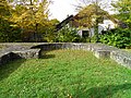
The remaining areas are designated as excavation protection areas. Above ground, only the foundation walls of the Porta Decumana and the fort bath have been preserved and partially reconstructed. They have been integrated into a modern residential area, provided with display cases and information boards and can be viewed.
Fort

The Niederbieber military camp was built in the last two decades of the second century AD to reinforce the Upper Germanic Limes, which had come under Germanic offensive pressure, at about the same time as the Holzhausen fort located southwest of it, in the area of today's Rhein-Lahn district . In the current research discussion, the founding dates are AD 185 and AD 193/194. A fragment of an honorary inscription for Emperor Septimius Severus (193–211), found in 1958 but not published until 1997, speaks for the latter date . The fort took the place of Fort Heddesdorf , which was only a few kilometers up the Rhine, and in the following decades was the largest, most strongly fortified and most important auxiliary fort in the northern Limes section. The rectangular floor plan with its rounded corners (playing card shape) covered an area of 5.25 hectares at 265.20 × 198.50 meters.
Enclosure


The camp was protected by a defensive wall between 1.50 meters and 1.60 meters thick in the rising area, in front of the 5.50 to 6.50 meters wide berm a 1.50 meters lower and between six and 6.50 meters wide ditch ran. Before digging, traces of other obstacles to the approach, such as smaller ditches for sharpened wood ( cippi ) and knots, could be found. These were located on an undeveloped strip about 100 to 150 meters wide that separated the fortification from the civilian settlement, the vicus .
The wall itself, whose foundation embroidery reached a thickness of up to 2.40 meters, was plastered on the outside with mortar, the lime coating with red lines on a white background simulated brickwork. At its corners, the enclosing wall was provided with massive, protruding towers. In addition, there were at least ten solidly walled intermediate towers, which with a width of 3.25 meters also protruded significantly outwards. The protrusion enabled comprehensive control of the entire area for the camp as well as flanking bombardment of the entire curtain wall . The size and bulk of the towers could indicate that their platforms were possibly also used as gun positions (ballistaria) for light arrow catapults, as these are first documented in writing for the early 3rd century in Britain. Behind the defensive wall was a three meter high embankment that sloped towards the interior of the camp. In order to prevent this mass of earth from sliding off, the dam was reinforced at its bottom with palisades and dry stone walls. On the wall itself was the battlement behind the crenellated surrounding wall.
Fortification details, such as the towers protruding far from the surrounding wall, and the defensive moat, which was unusually distant for forts of the Principate's time, clearly show the way from the medieval fortified barracks to the late antique fortress. In this respect Niederbieber was even the oldest fort at which these innovations - before the destruction of the 20th century - could be observed so completely.
The wall and the course of the moat were interrupted by four gates to all cardinal points, which were flanked by also protruding towers. To the south, at the narrow-sided Praetorialfont, the representative, 20.70 meter wide main gate, the Porta praetoria, opened . There were very similarly constructed entrances on the two long sides: the Porta principalis sinistra (left side gate) in the west and the Porta principalis dextra (right side gate) in the east. All three gates were designed as double gates more than 20 meters wide, each with two doorways, which had a clear width of three meters. Only the rear gate, the Porta Decumana opposite the Porta praetoria , deviated from this scheme. With a total width of 14.80 meters, it had only a single doorway three meters wide. With its Praetorialfont facing away from the Limes, the fort deviates significantly from the usual scheme of the Limes fort. Usually the main gate opened to the Limes. During the first excavation of the Porta decumana, which was then still around 0.60 meters high, in 1801, a large, hewn tuff stone was still found in the base area, which had the carved number XXV (25) on its back. All other corresponding stones had already broken out by then. It is possible that ancient stonemasons had carved the number in order to count their daily output, analogous to similar markings that are repeatedly discovered on Roman roof tiles. In the old reports, the rear gate, discovered in 1801, was supposedly referred to as Porta praetoria .
Interior constructions
After deducting all of the fencing and gate systems, a usable area of around 40,000 square meters remained inside the warehouse. The structure of this area was predetermined by the largely standardized building scheme of the Principate's time . Lagerringstrasse (Via sagularis) led around the built-up area along the fence and the towers . This area was divided into four parts by two main streets that meet at right angles in the warehouse center. The main camp street leading from the intersection of the streets to the south to the Praetorialfont with the Porta praetoria was called Via Praetoria. Opposite it was the Via Decumana , which ended at the Porta decumana . To the west, the Via principalis sinistra led to the Porta principalis sinistra , to the east the Via principalis dextra with the Porta principalis dextra . Above the crossing point there was a large vestibule in front of the central staff and administration building ( Principia ) . The east-west oriented central strip on which the Principia were built was the location of other important infrastructural buildings, such as the granary ( Horreum ) and a workshop (Fabrica) . The commandant's representative residence (praetorium) was also located here.
Principia
The approximately square principia , minus the large, rectangular vestibule , shared by the two units stationed in the fort (Numeri) , with its sides of 53.30 × 52.00 meters, took up an area of almost 2,800 square meters. There were so many clearly identifiable objects here that the purpose of the rooms on the preserved ground floor could still be identified. Such clear findings are extremely rare and can only be compared with the North African legion camp Lambaesis or the Dura Europos fort in Syria .
The service and administration rooms were grouped in the square around an open portico courtyard in which the skeleton of a man who had apparently fallen in battle was found with a lance. For the large vestibule, Dorow's excavation plan recorded several fixtures that could not come from the time it was built. In the armamentariae attached to the right of the inner courtyard , there were still numerous box fittings, locks and weapons. The rear, north-east running suite of rooms consisted of a total of nine rooms, the middle of which was the flag sanctuary with a semicircular apse. The other eight rooms served as offices. During his excavations, Ritterling was able to prove the sparse remains of hypocaust systems for some of these rooms . The easternmost of these rooms was used as a writing room (tabularium) for the Brittons. The excavators recovered the hinges, fittings and locks from filing cabinets here. In addition, the stone fragment of a genius of this office was found with a matching inscription. Vibius Mercurialis, the founder was a clerk (librarius) of the Numerus Brittonum Antoninianorum. The unit will have received the honorary name Antoninianorum during the reign of Emperor Caracalla. The room immediately to the east of the flag shrine belonged to the Schola (community) of standard bearers ( Vexillarii and Imaginifer ). The stone genius recovered there in October 1815 is written on a detailed inscription dated to the consulate:
- In h (onorem) d (omus) d (ivinae) Genio vexillar (iorum) et
- imaginif (erorum) Attianus Coresi vex (illarius)
- Fortionius Constitutus
- imag (inifer) signum cum (a) edic (u) la
- et tab (u) l (am) marmoream d (onum) d (ederunt) d (edicaverunt)
- Imp (eratore) d (omino) n (ostro) Gordi (a) no Aug (usto) et Aviola co (n) s (ulibus)
Translation: “In honor of the divine imperial house, the genius of the standard bearer and the bearer of the imperial portrait. Attianus Coresi, standard bearer, Fortionius Constitutus, bearer of the emperor's portrait, gave and consecrated this symbol with a shrine and a marble plaque as a gift. When the Emperor, our Lord Gordianus Augustus and Manius Acilius Aviola were consuls (239 AD). "
Dorow hid from the rear rooms of the staff building, among other things, cult objects such as a sandstone statuette and two votive feet made of iron and silver. A bronze statuette of a genius is said to have come to light in 1791 from a nearby flue. In addition to the location indicated by Dorow (1826) and later by Cohausen (1869), the Upper Germanic-Raetian Limes of the Roemerreiches (ORL) also said that the figurine was found in the main canal of the baths, but a list appears in the Principia much more likely. The Genius, which was still complete when it was found, at an unknown point in time lost a cornucopia that he was carrying in his hand. The two-phase inscription on the rectangular statue base testifies to the imperial cult practiced in the forts:
Left side:
- In h (onorem) d (omus) d (ivinae) baioli
- et vexillari (i) col-
- legio Victorien-
- sium signifer-
- orum Genium d-
- e suo fecerunt
- VIIII Kal (endas) Octobr (es)
- Pr (a) esente et Albino
- co (n) s (ulibus)
- h (i) XIIII d (e) s (uo) r (estituerunt)
Front:
- Satullus, Sattara, Macrinus, Laetus, Apollinaris, Secundanus, Ursus
Right side:
- Paternus, Prudens, Marianus, Dagovassus, Cerialis, Aturo, Victor
Translation: “In honor of the divine imperial family, the Baioli (messenger riders ?) And standard bearers had this genius made for the College of Victoriensium of the standard bearers at their own expense. On September 23, when Gaius Bruttius Praesens and Caius Allius Albinus were consuls (September 23, 246). "
The following lines of text and the 14 names listed above on the sides of the base come from a later point in time after 246 AD. Apparently the genius had been damaged in the meantime: "These 14 had this restored at their own expense."
The stated September 23rd was the birthday of the first Roman emperor Augustus , which was certainly no coincidence. The Roman military celebrated a large number of traditional imperial festivals. In addition to the correct translation for Baioli , the word Victoriensium also causes difficulties in this regard . The ancient historian Oliver Stoll followed the old research according to Dorow and considered being able to recognize the ancient place name of Niederbieber here, which the archaeologist Marcus Reuter , for example, rejected.
The furnishings of the Principia also included frescoes, the remains of which were discovered on chunks of plaster. Dorow describes that colored lines and leaves were preserved on a white lime ground.
Horreum and Fabrica
The Principia was flanked by a warehouse (Horreum) on the western side and a workshop (Fabrica) on the eastern side. Both buildings had an internal area of a good 650 square meters each. The Horreum had a wooden floor floating on posts, which, together with ventilation slots in the outer walls, provided the necessary air circulation for the storage of grain and legumes. In addition, the raised position of the floor made it difficult for small rodents to access food supplies. The other building was referred to as Fabrica ; its floor was at ground level and the findings showed a large amount of charcoal and iron slag. It was probably built as a horreum at first , but was later converted into a fabrica .
Praetorium
To the west of the horreum was the representative and comfortable residential building of the commandant, the so-called praetorium . His rooms had screed floors, the plastered walls were partly brightly painted. Some of the rooms had underfloor and wall heating, including the spacious, multi-part bathroom. Adjacent rubbish pits with the finds of high-quality drinking utensils and large quantities of oyster shells indicate the lifestyle of the camp commanders.
Crew barracks and stables
The teams were - like the horses of the partly mounted units - housed in the Praetentura and in the rear third of the Retentura . Eight men each lived in a two- room contubernium (shared room). Eight to ten such Contubernia were in each case in the elongated Centuria , the team barracks built in simple half-timbered construction. The captains ( centurions or decurions ) were accommodated in somewhat more spacious accommodations at the head of the barracks. The Stabulum equile (stables for the horses) were located in the immediate area of the team barracks . Two of the buildings uncovered in Niederbieber were addressed as stables, a larger one for around 80 horses and a smaller one for around 30 to 40 animals.
Fort bath
The large fort bath ( Balineum ) of Niederbieber is special in two respects . It was not located outside the camp - as is usually the case with Roman military camps - but was integrated into the Retentura (rear camp ), within which it is located immediately east of the Via Decumana and north of the Principia . And it was particularly large and lavishly designed. The bricks recovered in the bath with the stamps of the Legio VIII Augusta located in Argentoratum ( Strasbourg ) were either delivered here or erected by a construction team of the Legion. The Balineum, built directly with the fort under Commodus, testifies to the great commitment of the Strasbourg Legion on the Limes. The direct deployment of this troop could, for example, be documented in writing on the extension of the Osterburken fort.
The Niederbieber bath is a symmetrically designed double system which, in addition to the west-east division via the axis of symmetry, is also divided into an unheated southern and a heated northern part. Via the entrance area in the south, visitors first came to the unheated part, which most closely resembled a palaestra and was used for gymnastic and other sporting activities. Only then did the actual bathing area connect in the north. The visitor entered this via a seemingly rejuvenating apodyterium (changing room), followed by the usual rooms of a Roman thermal bath, frigidarium (cold bath room), tepidarium (hot bath room ) and caldarium (hot bath room) , each mirrored over the axis of symmetry, available twice.
The facility was heated by means of hypocausts , which were heated by a total of seven prefurnia (firing systems) on three sides of the actual bathing complex. The water supply was presumably taken from springs located about 1.7 kilometers to the northeast, near the not preserved Limes watchtower Wp 1/33. From this point, which was around 50 meters above the level of the fort, the drinking water was directed into the camp via a small opening in the northern fort wall. Traces of the former water pipes could still be found during the excavations of 1897. The waste water was disposed of via three channels, which were finally combined to form a main channel and led the collected sewage in the area of the Porta Decumana out of the fort.
- Fort bath

Model of the numerus bath

Preserved and reconstructed foundation walls of the fort bath

Part of the frigidarium with a semicircular piscina
apse


Troops and military personnel
The camp was probably designed from the beginning as a separate fort form for two numbers ("units", singular: number ), the strength of which clearly exceeded that of the usual numbers . A total of 1000 men will have been lying in Niederbieber. Two of these units stationed here are secured by inscription finds. These are the Numerus Exploratorum Germanicianorum Divitiensium (“Germanic Enlightenment Unit from Deutz”) and a Numerus Brittonum (“British Unit”).
Numbers of the Brittons occur relatively frequently on the Upper German Limes. They were set up in their British homeland and later assigned to the province of Germania superior , where they were used in particular in the area of the Odenwald Limes. The Numerus Exploratorum Germanicorum Divitiensium was a partially mounted special unit that was also deployed across the border for reconnaissance purposes. It may have been stationed first in the Cologne-Deutz area or split off from a troop stationed there and made into an independent unit. According to the Niederbieber findings, both units were commanded by a common commander - presumably the Praefectus of the Exploratores - but otherwise remained independent units. The entire garrison is likely to have taken on a variety of tasks in securing the northern Limes section, ranging from the provision of men for the Limes watchtowers to operational reconnaissance of the Limes foreland.
Near the road, on the left bank of the Aubache, a fragmented dedication was discovered, which had been dedicated to the genius of the medical ranks (Capsarii) of the Numerus Divitiensium Gordianorum by the medicus (h) ordinarius , the highest-ranking doctor, Titus Flavius Processus. The by the imperial honorific name on the reign of Gordian III. (238–244) datable inscription, on which the beginnings of the figure of Genius once standing above were still visible, also names the then commander of the unit (Praefectus numeri) , Caius Vibius Vitale.


Downfall
The fort crew fulfilled their tasks for a good seven decades before - according to older theories - they came to a violent end during a Franconian offensive or an Alemannic attack. In contrast, recent research tends to assume that Niederbieber perished in connection with the events surrounding the establishment of the Gallic Empire (Imperium Galliarum) in the summer or autumn of 260. The American historian Lawrence Okamura first expressed this theory after studying the findings. The treasure finds from Niederbieber were helpful in dating . In 1900 two hoards of coins were discovered on the fort, followed by another coin treasure six years later. The final coins of all three hoards come from the common reign of Emperor Valerian and his co-regent Gallienus (253–260). They support a landfill and the end of the fort during the final collapse of the Upper German-Raetian Limes 259/260 or shortly before that. Hoffmann had already discovered large amounts of animal bones around the staff building. According to Okamura, this finding could indicate that the animals were brought to the fort in the face of an impending siege after the crew had sided with the reigning sub-emperor Saloninus in Cologne . Saloninus was a son of the ruling Gallienus and had to defend himself in 260 against the ultimately successful usurper Postumus . The commander Postumus, active in the staff of Saloninus, turned against the regent, had him executed and founded the Gallic Empire, which existed until 274. Before that, the troops of Postumus could have attacked those army units that were openly against the usurper. According to Okamura, traces on the southern tower of the west gate that indicate an undermining of the wall cannot come from Teutons. He sees here signs of a Roman siege, in which the pioneers used a professional tunneling technique. After the soldiers of Postumus broke into the fort, they killed the defenders.
Particularly noticeable in connection with the sinking was the almost complete human skeleton that Hoffmann found in the rear area of the Principia , as it threw a clear spotlight on the last hours of the fort. As in the forts in Osterburken and Pfünz , the Niederbieber crew perished in battle. The skeleton leaned in a seated position against a wall of the schola immediately to the east of the flag shrine . In the context of the find, the remains of a silver field sign ( Signum ) were found , which included a "completely wrinkled" gold-plated relief disk and the remainder of the troop name Cohors VII Raetorum equitata ("7th partially mounted cohort of raiders "). There was also an iron helmet framed with sheet bronze. The fallen man was a signifer or imaginifer who had died on the spot defending his standard. Apparently he and his troops from the nearby Niederberg fort had rushed here to help and went down with the actual Niederbieber crew. The restored relief disk showed the image of a general or emperor. In the above-mentioned gilded relief disk, which Dorow found forcibly crushed and bearing a portrait, Okamura saw an image of Saloninus, who had been destroyed in their anger by the attackers.
Vicus
Around the fort there was the vicus , the civilian settlement in which dismissed military personnel, relatives of the soldiers as well as craftsmen, traders and service providers settled. The vicus of Niederbieber began after an approximately 100 to 150 meter wide, undeveloped strip that surrounded the entire fort, extended to the north right up to the Limes and was otherwise staggered to a depth of about 500 meters. It was bordered by a moat on its northeast and southeast side.
Within this area, no systematic arrangement of the individual houses could be made out. The buildings were not aligned with streets, but stood together in loose assemblies. The loose construction may suggest that horticulture played a certain role for the residents of the vicus. It was dominated by the strip houses typical of a fort village with their long rectangular shape. Some of the buildings, which were probably built using an adobe framework, had a basement, and only a few had heating. Representative sacred buildings were completely missing. In the course of extensive pumice stone mining in the area of the vicus , numerous building remains were only poorly documented, especially between the 1950s and 1970s. The wooden structures of the buildings are virtually unknown. The only evidence that has mostly been excavated are cellars, some of which were built in stone.
A bronze portrait of Emperor Gordian III comes from the southeastern camp village . (A.D. 240-244). The head was a small part of metal or mixed hoard , the Koenen 1894 in the heating channels a kiln found. Further large bronze fragments from Niederbieber belong to a tank statue. Their exact locations are unknown. However, they can be located between AD 185 and 260.
Limes course between the Niederbieber fort and the Anhausen small fort
From the Niederbieber fort place to the northeastern edge of today's Oberbieber, there are hardly any traces of the Limes in the populated or agricultural area. It is only from the Wingertsberg , on which the reconstruction of a watchtower is located, to the small fort Anhausen, that some legacies of the Limes can be found again in predominantly forested terrain.
Traces of the Limes structures between the Niederbieber fort and the Anhausen small fort :
| ORL | Name / place | Description / condition |
| ORL 1a | Niederbieber Castle | see above |
| Wp 1/31 | Suspected but not proven tower location. | |
| Wp 1/32 | Suspected but not proven tower location. | |
| Wp 1/33 | "At the Kreuzkirche" |
_wp_33_Lage.jpg&filetimestamp=20070810085453&) _wp_33_Grundriss.jpg&filetimestamp=20070810085700&) The tower site itself contained traces of two stone towers and an older wooden tower. Both stone towers were square and had walls 0.80 meters thick. The western stone tower, which was about 17 meters away from the moat, was slightly smaller with a side length of 4.50 meters than the eastern one, which had a side length of 4.85 meters. Both towers were surrounded by (drainage) ditches, but the western one was only about two thirds of the total circumference. From the previous wooden tower, which seems to have had a side length of approximately five meters, three postings could be determined under the eastern stone tower . In 2007 it was carefully cleared again whether the tower could be made visible on a Limes hiking trail as part of the Limes promotion program. After a positive result, the corners of the western stone tower were displayed in the area using gabions . |
| Wp 1/34 | Suspected but not proven tower location. | |
| Wp 1 / 35a | Suspected but not proven tower location. | |
| Wp 1/35 | Suspected but not proven tower location. | |
| Wp 1/36 | Even at the time of the Reich Limes Commission, only weak traces were found due to the concentration of finds in this area. There was and is nothing to be seen of the tower itself. | |
| Wp 1/37 | "On the Wingertsberg" |
 A faulty reconstruction can be found south of the actual tower site, about 30 meters away. |
| Wp 1 / 37a | Suspected but not archaeologically proven tower site on the basis of litter finds and the topographical conditions. | |
| Wp 1/38 | "Sand loop" |
_wp_38_Lage.jpg&filetimestamp=20070809233148&) _wp38_Grundriss_und_Schnitt.jpg&filetimestamp=20070809233820&) The entire Limes from Wp 1/18 to Wp 1/33, the Niederbieber fort and large parts of the western Neuwied basin could be viewed from the tower gallery. |
| Wp 1/39 | "On the Götz" |
  As with Wp 1/38, there was a good view of the Limes and the foreland. The traces of the Limes itself are well preserved in this area. |
| Wp 1/40 | "On the Alteck" |
  During the excavations in 1893, the palisade trench in this area was opened over a distance of around 20 meters. The result was a ditch up to 1.50 meters deep, 50 centimeters at the upper edge and 0.35 centimeters wide in the area of the bottom with the rotten remains of the palisade and isolated stones that had served to wedge the wood. |
| Wp 1/41 | "Anhausen" |
 Two construction phases could be proven: after a fire of unknown timing and cause, the tower was rebuilt. Further, even older construction phases cannot be ruled out. The building was surrounded by a pointed ditch 1.50 meters wide and a remaining depth of 0.80 meters at the time of the excavation. The rise of the building probably consisted of clay wickerwork or clay framework. |
| KK | Anhausen small fort | see main article Small fort Anhausen |
Lost property

The found material, provided it was not lost in the course of time, found its essential parts in the Rheinisches Landesmuseum Bonn . These include the most spectacular finds, such as the gold-plated silver relief disk with the associated inscription panel from the Principia and the top of an equestrian standard in the form of a dragon's head that came out of the ground in the camp village. Further finds can be found in the Landesmuseum Koblenz on the Ehrenbreitstein Fortress and - to a lesser extent - in the Neuwied District Museum ("Roentgen Museum" Neuwied), which originated from the collection of the "Association for Heritage and Archeology in the Neuwied District" and was inaugurated in 1928 . Today it is one of the most important museums in the Middle Rhine region.
Monument protection
The Niederbieber fort and the aforementioned ground monuments have been part of the UNESCO World Heritage as a section of the Upper Germanic-Rhaetian Limes since 2005 . In addition, the facilities are cultural monuments according to the monument protection law of the state of Rhineland-Palatinate . Research and targeted collection of finds are subject to approval. Incidental finds are to be reported to the monument authorities.
See also
literature
- Dietwulf Baatz : The Roman Limes. Archaeological excursions between the Rhine and the Danube. 4th edition. Gebr. Mann, Berlin 2000, ISBN 3-7861-2347-0 , pp. 95-99.
- Claus von Carnap-Bornheim : The bone objects from the fort and vicus in Niederbieber. In: Bonner Jahrbücher. 194, 1994, pp. 341-395.
- Hans Eiden : The Limes Fort Bendorf and Niederbieber. In: ders .: 10 years of excavations on the Middle Rhine and Moselle. Introduction, sites, finds. 2nd Edition. Office for Prehistory and Early History Rhineland-Palatinate, Koblenz 1977, pp. 36–42.
- Hans Eiden: The camp village of Niederbieber Fort. In: ders .: excavations on the Middle Rhine and Moselle. 1963-1976. Rheinisches Landesmuseum Trier 1982, ISBN 3-923319-01-0 , (Trier magazine for the history and art of the Trier region and its neighboring areas. Supplement, 6), pp. 137–169.
- Ernst Fabricius , Felix Hettner , Oscar von Sarwey (ed.): The Upper Germanic-Raetian Limes of the Roemerreich. Section A, Volume 1: Lines 1 and 2 (1936).
- Sybille Friedrich: The excavations of the Reich Limes Commission in the Niederbieber fort. In: The Limes. News bulletin of the German Limes Commission. 2, 2012 / issue 2, pp. 24-27. ( online pdf )
- Wolfgang Gaitzsch : The 'Roman' screw from the Niederbieber fort. In: Bonner Jahrbücher. 183, 1983, pp. 595-602.
- Michael Gechter: The primers from Niederbieber Fort. In: Bonner Jahrbücher. 180, 1980, pp. 589-610.
- Bernhard Gondorf: Two hundred years of scientific archeology in the Neuwied area. In: Heimat-Jahrbuch des Neuwied district. 1991, pp. 37-39.
- Alexander Heising : Perspectives on Limes Research using the example of Niederbieber Castle. In: Peter Henrich (Ed.): Perspektiven der Limesforschung. 5th colloquium of the German Limes Commission. (= Contributions to the Limes World Heritage. 5). Theiss, Stuttgart 2010, ISBN 978-3-8062-2465-8 , pp. 56-71 ( online ).
- Christian Friedrich Hoffmann: About the destruction of the Roman cities on the Rhine, between Lahn and Wied, by the Germans in the middle of the third century, as shown by the excavations near Neuwied. 2nd Edition. Neuwied 1823, digitized version, Bavarian State Library .
- Anne Johnson : Roman forts of the 1st and 2nd centuries AD in Britain and in the Germanic provinces of the Roman Empire. (= Cultural history of the ancient world . Volume 37). Zabern, Mainz 1987, ISBN 3-8053-0868-X .
- Cliff Alexander Jost : New excavations in the Niederbieber fort. In: Homeland yearbook of the Neuwied district. 2004, pp. 53-56.
- Cliff Alexander Jost: The Roman Limes in Rhineland-Palatinate. (= Archeology on the Middle Rhine and Moselle. Volume 14). State Office for Monument Preservation Rhineland-Palatinate, Koblenz 2003, ISBN 3-929645-07-6 , pp. 66–77.
- Cliff Alexander Jost: New excavations in the Roman fort Niederbieber, city of Neuwied. In: Archeology in Rhineland-Palatinate. 2002, Zabern, Mainz 2003, pp. 103-106.
- Margot Klee : The Limes between Rhine and Main. From the beginning of the Upper German Limes near Rheinbrohl to the Main near Grosskrotzenburg. Theiss, Stuttgart 1989, ISBN 3-8062-0276-1 , pp. 39-44.
- Margot Klee: Limes. Course 1, WP 1/1 - 1/93. In: Heinz Cüppers : The Romans in Rhineland-Palatinate. Licensed edition of the 1990 edition, Nikol, Hamburg 2002, ISBN 3-933203-60-0 , pp. 443–445.
- Franz Oelmann : The ceramics of the Niederbieber fort. Frankfurt am Main 1914. (2nd reprint. Habelt, Bonn 1976, ISBN 3-7749-0678-5 )
- Heinz Preißing: Traces of ancient history: Archeology in the Neuwied district. Geiger-Verlag, 1996, ISBN 3-89570-239-0 .
- Emil Ritterling : Niederbieber [fort]. In limes leaf. Notifications from the route commissioners to the Reichslims Commission. 31, 1899, col. 825-834.
- Emil Ritterling: The Nieder-Bieber fort. In: Ernst Fabricius , Felix Hettner , Oscar von Sarwey (ed.): The Upper Germanic-Raetian Limes of the Roman Empire . Department B, Volume 1, Fort No. 1a (1936).
- Marcus Reuter , Bernd Steidl: A new statue base for Septimius Severus from Niederbieber Castle. New aspects of the camp's founding date. In: Hans-Helmut Wegner (Ed.): Reports on archeology on the Middle Rhine and Moselle. (= Trier magazine. Supplement 23). Trier 1997, pp. 215-234.
- Marcus Reuter : Studies on the numeri of the Roman army in the middle imperial period. In: Reports of the Roman-Germanic Commission. 80, 1999, pp. 359-569, (= dissertation).
- Egon Schallmayer : Niederbieber, Postumus and the Limesfall. Stations in a political process. Report of the first Saalburg colloquium. (= Saalburg writings. 3). Saalburgmuseum, Bad Homburg 1996, ISBN 3-931267-02-4 .
- Konrad Schneider: The beginnings of Roman archeology in Niederbieber. In: Yearbook for West German State History. 22, 1996, pp. 61-94.
- Frank Unruh: Forts at the end. Teutons or Romans. Raids on Pfünz and Niederbieber. In: Hans-Peter Kuhnen (Ed.): Stormed - Cleared - Forgotten? The Limesfall and the end of Roman rule in southwest Germany. Württembergisches Landesmuseum, Stuttgart 1992, ISBN 3-8062-1056-X , pp. 67-68.
- Hans-Helmut Wegner: Neuwied-Niederbieber. Fort and vicus. In: Heinz Cüppers: The Romans in Rhineland-Palatinate. Licensed edition of the 1990 edition, Nikol, Hamburg 2002, ISBN 3-933203-60-0 , pp. 501–503.
Web links
- Kastell Niederbieber on the website of the Ministry of Education, Science, Youth and Culture Rhineland-Palatinate
- Niederbieber Castle on the website of the German Limes Commission
- The forts of Neuwied on the website of the German Limes Road
Remarks
- ↑ a b c Cliff Alexander Jost: Remains of one of the largest Limes forts - Niederbiber fort near Neuwied. In: The Limes. 3rd year 2009, issue 1. German Limes Commission, Bad Homburg 2009, pp. 8–12; here p. 10. (PDF download)
- ↑ Passed on by Wilhelm Dorow: Roman antiquities in and around Neuwied am Rhein, with floor plans, elevations and sections of the fort excavated there, and depictions of the objects found in it. Schlesinger, Berlin 1826.
- ↑ CIL 13, 7760 and CIL 13, 7750 .
- ^ Karl August von Cohausen: Caesar on the Rhine. In: Yearbooks of the Society of Friends of Antiquity in the Rhineland. Volume 47-48, 1869, pp. 1-65; here: pp. 45–46.
- ^ Karl August von Cohausen: Caesar on the Rhine. In: Yearbooks of the Society of Friends of Antiquity in the Rhineland. Volume 47-48, 1869, pp. 1-65; here: p. 47.
- ↑ Christian F. Hoffmann: About the destruction of the Roman cities on the Rhine between Lahn and Wied, by the Germans in the middle of the third century, as they have shown in excavations near Neuwied. 2nd Edition. Lichtfers & Faust, Neuwied 1823. (digitized version )
- ^ Wilhelm Dorow: Roman antiquities in and around Neuwied am Rhein, with floor plans, elevations and sections of the fort excavated there, and depictions of the objects found in it. Schlesinger, Berlin 1826. ( Digitized text volume 1826 panel volume 1827 Digitalization panel volume 1827 )
- ^ Wilhelm Dorow: The monuments of the Germanic and Roman times in the Rhenish-Westphalian provinces. Schlesinger, Berlin 1823–1826.
- ↑ a b c d e f g Oliver Stoll: Roman Army and Society. Franz Steiner Verlag, Stuttgart 2001, ISBN 3-515-07817-7 , p. 172.
- ↑ Alexander Bertram Joseph Minola: A brief overview of what happened among the Romans since Julius Caesar and the conquest of Gaul by the Franks on the Rhine river. With special regard to the patriotic antiquities. Mathieur, Cologne 1833. (digitized version / PDF download)
- ^ Karl August von Cohausen: Caesar on the Rhine. In: Yearbooks of the Society of Friends of Antiquity in the Rhineland. Volume 47-48, 1869, pp. 1-65; here: p. 45.
- ^ A b Ernst Heinrich Carl von Dechen: The tuff stone as a building material for the Romans on the Rhine. In: Yearbooks of the Society of Friends of Antiquity in the Rhineland. Volume 38, 1864, pp. 1-26; here: p. 5.
- ↑ Most of the results were published in the Bonn yearbooks of that time.
- ↑ a b c d e Frank Unruh: castles at the end. Teutons or Romans. Raids on Pfünz and Niederbieber. In: Hans-Peter Kuhnen (Ed.): Stormed - Cleared - Forgotten? The Limesfall and the end of Roman rule in southwest Germany. Württembergisches Landesmuseum, Stuttgart 1992, ISBN 3-8062-1056-X , pp. 67-68; here: p. 67.
- ↑ See Cliff Alexander Jost on the website of the Ministry of Education, Science, Youth and Culture Rhineland-Palatinate ( Memento of the original from August 11, 2007 in the Internet Archive ) Info: The archive link has been inserted automatically and has not yet been checked. Please check the original and archive link according to the instructions and then remove this notice. .
- ↑ Koblenz Archeology Directorate: The main entrance gate at Niederbieber Castle should be made tangible. Retrieved October 26, 2012.
- ↑ Marcus Reuter, Bernd Steidl: A new statue base for Septimius Severus from Niederbieber Castle. New aspects of the camp's founding date. In: Hans-Helmut Wegner (Ed.): Reports on archeology on the Middle Rhine and Moselle . (= Trier magazine. Supplement 23). Trier 1997, pp. 215-234.
- ^ Adam Günther: On the origin and settlement history of the Neuwied basin. In: Mannus. 3, 1911, pp. 1-27; here: p. 20.
- ↑ a b c Dietwulf Baatz: Buildings and catapults of the Roman army. Steiner, Stuttgart 1994, ISBN 3-515-06566-0 , p. 71.
- ^ Anne Johnson (German adaptation by Dietwulf Baatz): Römische Kastelle. Zabern, Mainz 1987, ISBN 3-8053-0868-X , pp. 13-114.
- ↑ a b c Oliver Stoll: The geniuses of Niederbieber. In: Oliver Stoll: Roman Army and Society. Franz Steiner Verlag, Stuttgart 2001, ISBN 3-515-07817-7 , p. 78.
- ^ A b c Karl August von Cohausen: Caesar on the Rhine. In: Yearbooks of the Society of Friends of Antiquity in the Rhineland. Volume 47-48, 1869, pp. 1-65; here: p. 58.
- ↑ Oliver Stoll: The geniuses of Niederbieber. In: Oliver Stoll: Roman Army and Society. Franz Steiner Verlag, Stuttgart 2001, ISBN 3-515-07817-7 , p. 79.
- ↑ CIL 13, 07752 .
- ^ Wilhelm Dorow: The monuments of the Germanic and Roman times in the Rhenish-Westphalian provinces. Volume 2, Schlesinger, Berlin 1826, p. 133.
- ↑ CIL 13, 07753 .
- ^ Anne Johnson (German adaptation by Dietwulf Baatz): Römische Kastelle. Zabern, Mainz 1987, ISBN 3-8053-0868-X , pp. 13-139 with illus.
- ^ Wilhelm Dorow: The monuments of the Germanic and Roman times in the Rhenish-Westphalian provinces. Volume 2, Schlesinger, Berlin 1826, p. 73.
- ↑ CIL 13, 07754 .
- ↑ Oliver Stoll: The geniuses of Niederbieber. In: Oliver Stoll: Roman Army and Society. Franz Steiner Verlag, Stuttgart 2001, ISBN 3-515-07817-7 , p. 178.
- ↑ Marcus Reuter: Studies on the numeri of the Roman army in the Middle Imperial period. In: Report of the Roman-Germanic Commission. 80, 1999, pp. 357-570; here: p. 489.
- ^ Wilhelm Dorow: The monuments of the Germanic and Roman times in the Rhenish-Westphalian provinces. Volume 2. Schlesinger, Berlin 1826, p. 59.
- ↑ Oliver Stoll: Roman Army and Society. Franz Steiner Verlag, Stuttgart 2001, ISBN 3-515-07817-7 , p. 174.
- ↑ Oliver Stoll: The geniuses of Niederbieber. In: Oliver Stoll: Roman Army and Society. Franz Steiner Verlag, Stuttgart 2001, ISBN 3-515-07817-7 , p. 77.
- ↑ CIL 13, 7750 , CIL 13, 7751 , CIL 13, 6761 , CIL 13, 11979
- ↑ CIL 13, 7749 , CIL 13, 7752 , CIL 13, 7762
- ^ Anne Johnson (German adaptation by Dietwulf Baatz): Römische Kastelle. Zabern, Mainz 1987, ISBN 3-8053-0868-X , pp. 13-37.
- ↑ CIL 13, 7749 .
- ↑ Oliver Stoll: Roman Army and Society. Franz Steiner Verlag, Stuttgart 2001, ISBN 3-515-07817-7 , p. 170.
- ↑ Martin Kemkes: The Limes. Rome's border with the barbarians. 2nd, revised edition. Thorbecke, Ostfildern 2006, ISBN 3-7995-3401-6 , p. 249.
- ^ Emil Ritterling: Two coin finds from Niederbieber . In: Bonner Jahrbücher of the Rheinisches Landesmuseum in Bonn and the Association of Friends of Antiquity in the Rhineland . tape 107 . A. Marcus and E. Weber's Verlag, 1901, ISSN 0068-0060 , p. 99–111 ( uni-heidelberg.de [PDF; accessed on 23 August 2019]).
- ↑ CIL 13, 7765
- ^ Ernst Künzl : Two silver tetrarch portraits in the RGZM and the Roman imperial portraits made of gold and silver. In: Yearbook of the Roman-Germanic Central Museum Mainz. 30, 1983, pp. 381-402; here p. 385.
- ^ Wilhelm Dorow: The monuments of the Germanic and Roman times in the Rhenish-Westphalian provinces. Volume 2, Schlesinger, Berlin 1826, p. 55.
- ^ Frank Unruh: castles at the end. Teutons or Romans. Raids on Pfünz and Niederbieber. In: Hans-Peter Kuhnen (Ed.): Stormed - Cleared - Forgotten? The Limesfall and the end of Roman rule in southwest Germany. Württembergisches Landesmuseum, Stuttgart 1992, ISBN 3-8062-1056-X , pp. 67-68; here: p. 68.
- ↑ Jost Mergen : Research in Archives and Collections - An example from Niederbieber Castle. In: Reports from the LVR-LandesMuseum Bonn. 01/2014, pp. 12-14.
- ↑ Martin Kemkes: The image of the emperor on the border - A new large bronze fragment from the Raetian Limes. In: Andreas Thiel (Ed.): Research on the function of the Limes. Volume 2, Konrad Theiss Verlag, Stuttgart 2007, ISBN 978-3-8062-2117-6 , p. 144.
- ↑ ORL = numbering of the Limes structures according to the publication of the Reich Limes Commission on the O bergermanisch- R ätischen- L imes
- ↑ ORL XY = consecutive numbering of the forts of the ORL
- ↑ Wp = W oh p east, watch tower. The number before the slash denotes the Limes section, the number after the slash denotes the respective watchtower.
- ↑ Wp 1/31 suspected at around 50 ° 28 ′ 14.48 ″ N , 7 ° 28 ′ 22.29 ″ E
- ↑ Wp 1/32 suspected at about 50 ° 28 '29.31 " N , 7 ° 28' 34.95" O
- ↑ Western stone tower, the tower location Wp 1/33 at 50 ° 28 '43.49 " N , 7 ° 28' 48.13" O
- ↑ Eastern stone tower, the tower location Wp 1/33 at 50 ° 28 '43.56 " N , 7 ° 28' 48.79" O
- ↑ wood tower, the tower location Wp 1/33 at 50 ° 28 '43.56 " N , 7 ° 28' 48.79" O
- ↑ Cliff Alexander Jost: Investigations at old excavation sites of the Reich Limes Commission on the Limes between Wied and Saynbachtal. In: Peter Henrich (Ed.): Perspektiven der Limesforschung. 5th colloquium of the German Limes Commission . (= Contributions to the Limes World Heritage. Volume 5). Theiss, Stuttgart 2010, ISBN 978-3-8062-2465-8 , pp. 19-21.
- ↑ Wp 1/34 suspected at about 50 ° 28 '42.9 " N , 7 ° 29" 9.91 " E
- ↑ Wp 1 / 35a suspected at about 50 ° 28 '37.98 " N , 7 ° 29' 42.43" O .
- ↑ Wp 1/35 suspected at about 50 ° 28 '36.16 " N , 7 ° 29' 53.95" O .
- ↑ Wp 1/36 at approximately 50 ° 28 '35.85 " N , 7 ° 30' 7.8" O
- ↑ stone tower, the tower location Wp 1/37 at 50 ° 28 '39.94 " N , 7 ° 30' 34.25" O
- ↑ wood tower, the tower location Wp 1/37 at 50 ° 28 '39.94 " N , 7 ° 30' 34.25" O
- ↑ According to Baatz, pp. 92 and 98, the ground floor of a Limes watchtower has no external access, so the entrance must have been significantly higher. A half-timbered construction on a stone tower is also highly unlikely and the tower was certainly plastered and covered with a roof made of shingles or reeds / straw. Incidentally, the tower is much too small.
- ↑ Incorrect reconstruction of the stone tower of the tower site Wp 1/37 at 50 ° 28 ′ 38.6 ″ N , 7 ° 30 ′ 35.05 ″ E
- ↑ Wp 1 / 37a suspected at around 50 ° 28 ′ 40.78 ″ N , 7 ° 30 ′ 56.44 ″ E
- ↑ stone tower, the tower location Wp 1/38 at 50 ° 28 '42.07 " N , 7 ° 31' 4.06" O
- ↑ wood tower, the tower location Wp 1/38 at 50 ° 28 '42.07 " N , 7 ° 31' 4.06" O
- ↑ Wp 1/39 at 50 ° 28 '45.56 " N , 7 ° 31' 23.48" O
- ↑ Wp 1/40 at 50 ° 28 '52.34 " N , 7 ° 31' 53.19" E
- ↑ Wp 1/41 at 50 ° 28 '55.04 " N , 7 ° 32' 17.41" O
- ↑ KK = unnumbered K linseed K astell
- ^ Heinz Günter Horn : Cohors VII Raetorum equitata. Signum disc from Niederbieber. (= The Rhenish State Museum Bonn / reports from the work of the museum. 17). 1982, pp. 52-55 .; Jost Mergen: A "milk-bearded Roman" becomes the 200th blog of the LVR-LandesMuseum Bonn 2014.
- ↑ Image of the dragon head standard from Niederbieber ( memento of the original from July 26, 2007 in the Internet Archive ) Info: The archive link has been inserted automatically and has not yet been checked. Please check the original and archive link according to the instructions and then remove this notice. .
- ↑ Official website of the Neuwied District Museum ( Memento of the original from April 3, 2008 in the Internet Archive ) Info: The archive link was inserted automatically and has not yet been checked. Please check the original and archive link according to the instructions and then remove this notice.
