
Heddesdorf fort
| Heddesdorf fort | |
|---|---|
| limes | ORL 1 ( RLK ) |
| Route (RLK) |
Upper German Limes , route 1 (Rhine-Lahn) |
| Dating (occupancy) | Domitian until the end of the 2nd century |
| Type | Cohort fort |
| unit | a) Cohors XXVI voluntariorum civium Romanorum b) Cohors II Hispanorum equitata pia fidelis |
| size | 160 m × 180 m = 2.8 ha |
| Construction | stone |
| State of preservation | almost completely built over, a wall fragment preserved |
| place | Neuwied - Heddesdorf |
| Geographical location | 50 ° 26 '11.5 " N , 7 ° 28' 9.5" E |
| height | 65 m above sea level NHN |
| Subsequently | ORL 2: Fort Bendorf (east-south-east) |
| Upstream | ORL 1a: Niederbieber fort (north; followed the Heddesdorf fort in time) |
The fort Heddesdorf was a Roman frontier fort of the Upper Germanic Limes , the status since 2005 UNESCO world cultural heritage has. The former cohort fort is now a ground monument in an almost completely built-up area of Heddesdorf , a district of Neuwied in the Neuwied district of the same name in Rhineland-Palatinate .
location

Topographically, the fort is located at a height of around 65 m on the back of a flat hill, which rises above a loop of the Wied and which slopes down to the Rhine , the Wied and the Westerwald , but rises several hundred meters further to the southeast. In terms of traffic geography, this point was important insofar as it was able to monitor the traffic running parallel to the Wiedtal via a Roman road from the heights of the Westerwald to the Rhine. Another Roman road connection led from the fort in a south-easterly direction to the next neighboring military site, the Bendorf fort . Furthermore, a far-reaching view over the foreland of the Westerwald from the Rhine to the foot of the mountains was guaranteed at this point. Even in the wars of modern times, the outstanding strategic position of the square was used for military purposes.
The garrison is about 3.5 km away from the Limes , which passes the Neuwied area in a northerly direction, and the Niederbieber fort located directly there , which replaced the Heddesdorf camp.
In today's townscape, the location of the fort is roughly described by the area formed by Beringstrasse, Dierdorfer Strasse, Tannenbergstrasse and Wallstrasse, with Tannenbergstrasse a little further to the northeast than the former Praetorial Front (front) of the camp. The Geschwister-Scholl-Strasse between Dierdorfer Strasse and Wallstrasse corresponds almost exactly to the course of the former Via Principalis (the main camp road running across the fort and the Principia (commandant's office)). The Geschwister-Scholl-Schule is located just outside the Retentura (rear part of the camp) directly at the point where the fort bath was once located.
Research history

Due to the accumulation of Roman finds, Heddesdorf was known as the likely location of a Roman settlement as early as the middle of the 18th century. The first excavations took place between 1791 and 1820, during which numerous wall sections were exposed and extensive finds were recovered. Due to the nearby fort in Niederbieber , the existence of a further military presence in this area was initially ruled out and more likely a civilian settlement was assumed. Only after the Niederbieber military camp had been dated to the period between 185/190 and 260 was an older fortification in Heddesdorf finally considered possible and through a targeted excavation by the Reich Limes Commission under the local direction of Robert Bodewig in the summer of 1898 definitely proven.
Further extensive excavations were necessary in the 1960s and 1970s due to the brisk construction activity during this period. While the fort itself was the focus of research in the 19th century, the civil camp village now formed the focus of the investigations carried out by the then State Office for Prehistory and Protohistory in the administrative districts of Koblenz and Montabaur .
Fort

The Heddesdorf fort is a stone fort with sides of around 160 by 180 meters, which corresponds to an area of around 2.8 hectares. The defensive wall had the usual four gates, each flanked by two towers. The rounded corners of the defensive wall were also provided with watchtowers. There were also intermediate towers, one between the corner and the gate towers, making a total of eight. In front of the defensive wall - after a berm one to one and a half meters wide - there was a ditch about eight meters wide and up to 2.65 meters deep as an obstacle to the approach. With its Praetorial Front, the camp faced northeast, towards the Limes.
Few areas could be examined inside the camp. The few findings found here are ambiguous and do not allow any reliable statements about the internal structure of the fortification.
According to the finds, the fort was built in the 80s or 90s of the first century AD. It was first documented by the Cohors XXVI voluntariorum civium Romanorum ("26th cohort of volunteer Roman citizenship "), then by the Cohors II Hispanorum equitata pia fidelis ("2nd partially mounted Spanish cohort with the honorary name of the pious, the loyalty") by a pure infantry, then by a mixed infantry / cavalry unit of about 500 men each. Around 185/190 the garrison was replaced by the Niederbieber fort. Whether and how long it possibly survived beyond the time the successor fort was built is unclear at the current state of research. The ancient name of the Heddesdorf garrison town has not been passed down.
The finds from the fort area include four fragments of a tank statue that date between AD 140 and 160.
Fort bath


Immediately to the side of the camp, only a few meters southeast of the Porta principalis pextra (right camp gate) was the Balineum , the bathing complex found at every Roman fort. As a rule, as here in Heddesdorf, the thermal baths were built outside of the purely military fort area and were also available to the civilian population of the vicus for a small fee. The Heddesdorfer Therme is a bath of the so-called row type, in which the individual stations of the bathing process could be entered one after the other.
The visitor entered the bathroom and reached the apodyterium (changing room, “A”) through a large vestibule ( Basilica thermarum , marked with an “X” in the drawing ). From there he could either go through a corridor (“G”) to the sudatorium (sweat bath, “H”) or the frigidarium (cold bath, “B”), which had a piscina (water basin). Via two tepidariums (leaf vaults, “C”), it finally reached a three-part caldarium (hot baths, “D”), the middle part of which had two apses .
The system was heated via two praefurnia (firing points “p” and boiler room “K”) on each side of the caldarium and the sudatorium . Floor heating was detected in the hot and sweat bath as well as in one of the tepidariums . The apodyterium , which is relatively close to the firing points in the building complex and bordering heated rooms on two sides, is likely to have benefited from a certain amount of residual heat.
The function of three peripheral spaces (marked with "E", "X" and "Y" in the figure) is still unclear. Sparse wall fragments of the fort bath are now in the break hall of the Geschwister-Scholl-Schule built on this site.
Vicus and burial ground
Immediately in front of the fort was the vicus , the civilian settlement where former soldiers, members of the military, innkeepers, traders, craftsmen and service providers settled. The vicus of Heddesdorf was found to be 400 to 500 meters wide to the east, south and south-west of the camp. Numerous foundations of houses, some of which had a cellar and consisted of half-timbered structures, as well as other traces of settlement (wells, ditches, pits, etc.) were found here, and extensive finds were recovered.
The Vicu s was crossed by a road that began at the Porta principalis dextra and from there led to the next Roman garrison, the Bendorf Fort. At the end of the settlement strip, the extensive burial grounds began on both sides of the road.
Preservation of findings, lost property and monument protection
The area of the former cohort fort and its vicus is densely built up today. Unless they were destroyed in the course of the construction work, the findings are no longer visible above ground. The only exception are a few fragments of the wall, which can be viewed in the break hall of the Geschwister-Scholl-Schule.
Large parts of the finds from Heddesdorf were recorded in the Rheinisches Landesmuseum Bonn and in the Landesmuseum Koblenz at the Ehrenbreitstein Fortress .

Inscriptions and stone finds
(1898)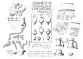
Inscriptions and ceramic finds
(1898)
Legion and cohort stamp
(1898)


The Heddesdorf fort has been part of the UNESCO World Heritage as a section of the Upper German-Rhaetian Limes since 2005 . In addition, this ground monument is protected as a registered cultural monument within the meaning of the Monument Protection and Maintenance Act (DSchG) of the state of Rhineland-Palatinate. Research and targeted collection of finds are subject to approval. Incidental finds are to be reported to the monument authorities.
See also
literature
- Dietwulf Baatz : The Roman Limes. Archaeological excursions between the Rhine and the Danube. 4th edition, Gebr. Mann, Berlin 2000, ISBN 3-7861-2347-0 .
- Robert Bodewig : The fort Heddesdorf . In: Ernst Fabricius , Felix Hettner and Oscar von Sarwey (eds.): The Upper Germanic-Raetian Limes of the Roemerreich . Department B, Volume 1, Fort No. 1 (1903).
- Ernst Fabricius, Felix Hettner, Oscar von Sarwey (ed.): The Upper Germanic-Raetian Limes of the Roemerreich. Section A, Volume 1: Lines 1 and 2 (1936).
- Cliff Alexander Jost: The Roman Limes in Rhineland-Palatinate . (Archeology on the Middle Rhine and Moselle, Volume 14). State Office for Monument Preservation Rhineland-Palatinate , Koblenz 2003, ISBN 3-929645-07-6 .
- Cliff Alexander Jost: The Upper Germanic-Raetian Limes with its forts in Neuwied-Heddesdorf, Bad Ems, Marienfels and Hunzel . In: Hans G. Kuhn (Ed.): Professor Dr. Robert Bodewig . Vol. 2: Smaller writings, life and work. Imprimatur, Koblenz 2005, ISBN 3-9807361-7-2 , p. 310ff.
- Margot Klee : The Limes between Rhine and Main. Theiss, Stuttgart 1989, ISBN 3-8062-0276-1 .
- Hans-Helmut Wegner: Neuwied-Heddesdorf. Cohort fort. In: Heinz Cüppers : The Romans in Rhineland-Palatinate. Licensed edition, Nikol, Hamburg 2002, ISBN 3-933203-60-0 , pp. 500f.
Web links
- Kastell Heddesdorf on the website of the Ministry of Education, Science, Youth and Culture Rhineland-Palatinate
- Fort Heddesdorf on the website of the German Limes Commission
- The forts of Neuwied on the website of the German Limes Road
- The Limes in the Neuwied area on the official website of the city of Neuwied
Remarks
- ↑ average value. Porta Principalis Dextra 66.09 Porta Principalis Sinistra 64.88 West corner 66.32 North corner 63.64 East corner 64.96 South corner 65.37 m above sea level NN
- ^ Leopold Bleibtreu : Memories from the war events near Neuwied from 1792 to 1797 . Georgi, Bonn 1834, p. 120 ff.
- ↑ So in the more recent literature. The Reich Limes Commission had determined and documented an aspect ratio of 154.70 by 183.35 meters (ORL Section B, Vol. 1, p. 2f.), Which also corresponds to an area of around 2.8 hectares.
- ↑ Not all of these towers have been archaeologically proven, but based on the excavated findings they can be assumed to be highly probable.
- ↑ These honorary names were given to the cohort after it had distinguished itself in the Saturnius uprising of 88/89 AD. In addition to Heddesdorf, the cohort has also been found in the forts of Bad Wimpfen , Stockstadt , and Rottweil. In Wimpfen it is documented for the period from 90 to 122 AD. In 122 she was assigned to Stockstadt and at a later date that cannot be determined more precisely, she came to Heddesdorf.
- ^ According to Philipp Filtzinger : Brick temple of Roman troops in Rottweil. In: Ders .: Arae Flaviae - The Roman Rottweil ( Memento from September 29, 2007 in the Internet Archive ) . Online edition of the University of Tübingen, Tübingen 2005.
- ↑ Martin Kemkes : The image of the emperor on the border - A new large bronze fragment from the Raetian Limes . In: Andreas Thiel (Ed.): Research on the function of the Limes , volume 2. Konrad Theiss Verlag, Stuttgart 2007, ISBN 978-3-8062-2117-6 , p. 144.
- ↑ DschG or DSchPflG RP
