Lindenallee (Bremerhaven)
| Avenue of lime trees | |
|---|---|
| Street in Bremerhaven | |
| Basic data | |
| city | Bremerhaven |
| district | Wulsdorf |
| Created | around 1850 |
| Cross streets | Lüneburger Strasse Bremer Strasse, Dreibergen , Sandbredenstrasse, Vieländer Weg, Speckbacherstrasse, Poggenbruchstrasse, Bei den Lehmkuhlen, Jedutenberg, Stellmacherweg, Korbmacherweg, Weg 89 |
| use | |
| User groups | Cars, bikes and pedestrians |
| Road design | two lane road |
| Technical specifications | |
| Street length | 2000 meters |
The Lindenallee is a central access road in Bremerhaven , Wulsdorf district (Dreibergen, Jedutenberg). It leads in a west-south-east direction from Weserstraße to, but not to the federal highway 27 and over the federal highway 71 as well as to Loxstedt , Beverstedt and Bremervörde .
The cross streets and the connecting streets were named u. a. as Lüneburger Straße after the city, Bremer Straße, Dreibergen after the district and the three sand ridges between Markfleet and the valley of the Rohr, Sandbredenstraße after a corridor in the field of Lithbreden , Vieländer way after the former judicial district and the landscape, unnamed way, Speckbacherstraße (?) (?), Pogge Bruchstraße, the Lehmkuhlen , Jedutenberg after the district and the artificially raised Jedutenhügel , Stellmacherweg after the occupation, Korbmacherweg (?) after the craft, route 89, unnamed roads; otherwise see the link to the streets.
history
Surname
The linden avenue was named after the linden , a genus of the Mallow family (Malvaceae). In Central Europe there are mostly winter or summer linden trees. Many places used to have their village linden. After wars there was the custom of planting so-called peace linden trees.
development
Wallestorpe was first mentioned in 1139. The cluster village belonged to the judicial district of Vieland around 1500 . In 1715 the area came to the Electorate of Braunschweig-Lüneburg , since 1815 Kingdom of Hanover . In 1850 the around 600 inhabitants of the rural community (1840) lived around the church in mostly thatched houses. The road to Beverstedt was built around 1850. At its confluence, the Lindenstrasse to Weserstrasse (mostly also called Chaussee), another new center of the place developed. After the construction of the Weser ports, the district grew considerably and in 2017 it had 11,351 inhabitants.
traffic
An old road connection to u. a. Loxstedt was expanded as a road around 1850. From 1932 the road was part of the trunk road 71, then Reichsstrasse 71 and after 1949 Bundesstrasse 71 . The Bundesautobahn 27 with the connection Bremerhaven-Wulsdorf via the B 71 was completed in this area in 1974. In December 2006 there was a southern bypass, which replaced the avenue of lime trees.
In the BremerhavenBus local traffic, the lines 501 and 506 pass through the street as well as the ML on the weekend nights.
Buildings and facilities
The street has predominantly one to two-storey buildings.
Notable buildings and facilities
- No. 1: 1- and 2-layered modern corner house with the branch of Volksbank Bremerhaven-Cuxland
- No. 2: 3-storey residential and commercial building with a central 4-storey building. gable
- No. 17: 2-sch. Gable-independent residential and commercial building from around 1900
- No. 23: 1-sch. Building of the Wulsdorf Volunteer Fire Brigade
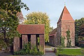
- Bremer Straße: Romanesque , Protestant Dionysius Church as a field stone church and fortified church from the 11th century, free-standing bell tower from the 15th century.
- Sandbredenstraße No. 11: 2- and 3-storey, brick- faced , four-class Altwulsdorf school from 1866 with other buildings; today a primary school
- Dreibergen No. 21: 3-ply New building from around 1961 of the Paula Modersohn School ( Die Paula ), a secondary school
- Wulsdorf district meeting place
- No. 38: 2-sch. Residential and commercial building from around 1900 with half-timbered gable
- No. 57: 2-sch. House from around 1900 as a gabled house
- No. 59: 3-sch. House from around 1900
- No. 61: 2-sch. House from around 1900 as a gabled house
- No. 73: 2-sch. Residential and commercial building from around 1900 with gable , crooked hip and café
- Fields
- Bridge over the Rohr, a right tributary of the Alte Lune, a tributary to the Weser
- Tunnel under the highway
literature
- Harry Gabcke , Renate Gabcke, Herbert Körtge, Manfred Ernst: Bremerhaven in two centuries; Volumes I to III from 1827 to 1991. Nordwestdeutsche Verlagsgesellschaft, Bremerhaven 1989/1991, ISBN 3-927857-00-9 , ISBN 3-927857-37-8 , ISBN 3-927857-22-X .
Individual evidence
- ^ Paul Homann: Bremerhaven route networks (public transport) since 1881 . In: BremerhavenBus website.
- ↑ Monument database of the LfD Bremen
- ↑ Monument database of the LfD Bremen
Coordinates: 53 ° 30 ′ 10.9 ″ N , 8 ° 36 ′ 29.4 ″ E


